REVIEW 4 major objections 6 minor 45 references
Real-Time Fusion of Visual and Chart Data for Enhanced Maritime Vision
T0 review · 4 major / 6 minor · reviewed 2026-08-06 · deepseek-v4-flash
Pith's one-line read The paper claims that replacing standard transformer queries with chart-marker embeddings lets a DETR-based network detect buoys and associate them to nautical charts in one forward pass, without Hungarian matching or post-processing.
desk verdict Chart-conditioned DETR is a real idea, but the single-video evaluation and unquantified chart errors keep the central claim short of established. read the letter →
The pith
A machine-rendered reading of the paper's core claim, the machinery that carries it, and where it could break.
The reading
What carries the argument
The load-bearing mechanism is the buoy query: a variable number of chart markers within a conservative field-of-view and distance filter, each encoded as a $(\text{dist}, \text{bearing})$ tuple and mapped by an MLP to a $d_{\text{model}}$-dimensional embedding injected into the transformer decoder. This embedding carries a strong spatial prior, steering cross-attention to the image regions where that particular buoy should appear. Since each query is tied to a chart marker, the network's output identifies the marker as well as its bounding box, so association is free. The RT-DETR variant uses deformable attention where each query samples $\Delta p$ points; the authors show accuracy rises with sampling points up to 64 in their setup.
What would settle it
On a sequence containing a buoy whose chart position is intentionally displaced by a known offset, such as 10 meters, a model robust to chart error would still associate the query to the visible buoy; if the predicted bounding box instead shifts toward the chart position or the visibility score drops, the paper's acknowledged close-range failure mode is confirmed.
Extended reading notes
Core claim
The central claim is that correspondence between detections in the image and buoys in a nautical chart can be learned end-to-end when each chart marker is converted into a learned query. Concretely, filtered chart objects are represented by their distance and bearing to the camera, passed through an MLP to form decoder input embeddings $v \in \mathbb{R}^{N \times d_{\text{model}}}$; the decoder then runs self-attention among these buoy queries and cross-attention to image features from the encoder. Each query predicts normalized bounding box coordinates plus a visibility score. Because query identity is fixed, the ground-truth correspondence is known and training can use plain BCE plus L1/GIoU losses without Hungarian matching. The paper reports that this design, especially on an RT-DETR backbone, yields F1 of 0.893 and mean IoU of 0.744 at 22.8 FPS, surpassing the two baseline pipelines on the authors' dataset.
Load-bearing premise
The load-bearing premise is that the labeling tool and the chart data used for ground truth are correct, so every queried marker's chart position matches the buoy's real location; the paper itself notes in its discussion that incorrectly mapped chart markers cause failures at close range.
Editorial extensions
If this is right
- The Fusion Transformer removes the need for Hungarian matching and post-processing in chart-video correspondence, simplifying deployment.
- The RT-DETR variant achieves F1 0.893 and mean IoU 0.744 at 22.8 FPS on the test sequence, supporting real-time AR chart overlay.
- The DETR variant already outperforms both baselines (F1 0.864 versus 0.857 and 0.533), so the improvement does not depend on the specific transformer variant.
- Since each prediction is tied to a chart marker, the output carries object identity, enabling direct frame-to-frame association.
- Accuracy scales with the number of deformable sampling points up to the tested 64, giving a tunable trade-off between speed and association quality.
Reading between the lines
- The same query-as-catalogue design could generalize to any georeferenced object set, such as fixed navigation lights, AIS-reported vessels, or city landmarks; the paper suggests broader applicability but does not demonstrate it.
- The chart-accuracy vulnerability acknowledged in the discussion implies the reported gains may shrink on waterways with stale or displaced chart markers; measuring that degradation would require a dataset with chart-error annotations.
- An informative stress test would perturb the vessel pose used to encode queries and measure how quickly F1 drops, quantifying how much of the gain relies on accurate position and heading estimates.
Editorial analysis
A structured set of objections, weighed in public.
Referee Report
Summary. The paper proposes a maritime vision system that fuses video with nautical chart data by replacing DETR/RT-DETR object queries with chart-derived buoy queries. Each query encodes the distance and bearing of a chart marker relative to the camera, and the transformer decoder predicts a bounding box and visibility score per buoy, producing an end-to-end correspondence between image detections and chart markers without Hungarian matching. The authors train on a custom dataset of 6,257 frames with 1,052 validation frames and evaluate on a single exhaustively labeled test video sequence. They compare against a ray-casting baseline and a YOLOv7-based distance-estimation baseline, reporting that a RT-DETR-based fusion variant achieves F1 0.893 at 22.8 FPS, versus 0.857 and 18 FPS for the best baseline. Ablations cover learned versus MLP decoder embeddings and the number of deformable-attention sampling points.
Significance. If the reported results hold, the work offers a practical and conceptually clean way to inject chart priors into a transformer detector, removing hand-crafted matching and post-processing. The main strengths are the end-to-end design, the variable number of queries tied to actual chart objects, the simple supervised loss made possible by known query-label correspondences, and the promised release of code, videos, chart data, labels, and labeling tool, which would support reproducibility. The ablations on embedding type and sampling points are useful. However, the significance is currently limited by external validity: the comparative claim rests on a single test sequence, there is no uncertainty quantification, and the evaluation is confounded by the use of the same chart positions for both labels and query embeddings. The methodological novelty is modest, but the application and the real-time feasibility evidence are of interest to the maritime vision community if the evidence base is strengthened.
major comments (4)
- [Section 4.3, Table 1] The entire comparative claim rests on a single exhaustively labeled test video sequence. No confidence intervals, bootstrap resamples, or statistical tests are reported. The differences between the RT-DETR fusion F1 (0.893), DETR fusion F1 (0.864), and the distance-estimation baseline F1 (0.857) are small relative to what per-frame variability can produce, and Figure 6's distance-binned F1 suggests strong dependence on scene composition. Please evaluate on multiple held-out sequences, or at least provide per-frame or bootstrap variance, before claiming that the approach 'significantly improves' association accuracy.
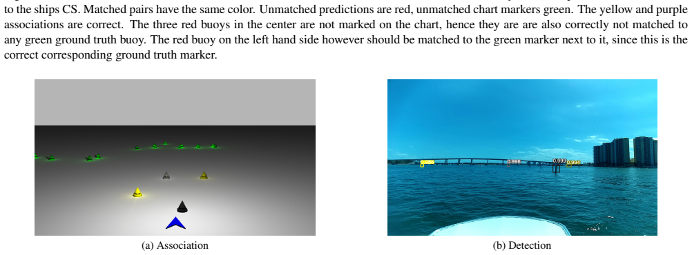
- [Section 3.2 and Section 5] Both the training correspondences and the decoder query embeddings are derived from the same NOAA chart positions. The paper concedes in Section 5 that incorrectly mapped chart markers cause failures at close range, yet no chart-accuracy check, independent re-annotation, or sensitivity analysis to chart-position noise is provided. Since the same chart positions enter the labels and the queries, any chart error is shared by the method and the metric; the baselines use the same markers but through geometric matching, so the reported advantage could be inflated or deflated by chart errors. Please quantify chart marker accuracy on the test site or inject controlled synthetic position noise and report F1 as a function of noise magnitude.
- [Section 4.5, Table 3] The RT-DETR variant's sampling-point count (64) is chosen after observing performance on the test sequence; Table 3 shows F1 rising from 0.839 at 4 points to 0.893 at 64 points. This is effectively test-set hyperparameter selection, and no validation split or selection protocol is described. The claimed superiority of the RT-DETR variant may partly reflect this selection; please report how sampling points were chosen, for example on the validation split, and whether the F1 gap persists under that protocol.
- [Section 4.2] The comparison conflates detector architecture, association strategy, and calibration effort. The baselines require online focal-length and heading-bias calibration plus ByteTrack smoothing, while the transformer receives distance and bearing features computed from the same camera-pose and chart data used to build the labels. If the baseline calibration is not carefully controlled, their performance may be artificially low. Please report calibration accuracy for the baselines and, if possible, include an oracle variant that uses ground-truth distance and bearing for the baselines, to separate association architecture from feature quality.
minor comments (6)
- [Section 4.2, ray-casting equations] The ray-casting equations reuse the symbol v for both the visibility score and the pixel coordinate; rename the pixel coordinate (for example, v_pix) to avoid confusion.
- [Section 3.1.3, loss equation] The loss equation is unnumbered and the batch-averaging details mentioned in the text are not visible in the displayed formula; please make the division by the number of queries explicit and align the equation with the described implementation.
- [Section 3.2, dataset split] The relation between the 1,052 validation frames and the dedicated test sequence is not stated; please clarify whether validation and test frames come from different video sequences and confirm that no validation frames overlap the test sequence.
- [Section 4.2, notation] The transformation matrix ShipTCam is used without defining its coordinate convention; please specify the rotation order and the source of the translation vector.
- [Global] There are several typos, including 'UA Vs' in Section 2.1 and 'migitated' in Section 4.5; please proofread the manuscript.
- [Figure 6] The distance-binned F1 plot would be easier to interpret if the number of objects per distance bin were printed numerically; the top distribution is hard to read quantitatively.
Circularity Check
No derivation-level circularity; shared chart-source confounding is a data-quality issue, not a circular argument.
full rationale
None of the enumerated circularity patterns is present in the claimed derivation. The loss (Section 3.1.3) explicitly uses known query-label correspondences: 'Contrary to DETR based object detectors our approach does not require to compute a hungarian matching between predictions and labels, since the correspondence between ground truth bounding box labels and queries is known.' This is a standard supervised detection objective, not a self-definitional loop. The headline results in Table 1 are measured on a held-out, exhaustively labeled test sequence, and the network must predict bounding boxes and visibility scores from image features in addition to the chart-derived distance/bearing query embeddings; the chart query alone does not determine the reported F1 of 0.893. Thus the 'prediction' is not a fitted input renamed as a result. The paper's own limitation statement—'all the algorithms have difficulty accurately matching detected buoys to the corresponding chart markers when the chart markers are incorrectly mapped'—shows that the shared NOAA chart source feeding both queries and ground-truth associations is a real data-quality confound, but confounding is not circularity: the ground truth is produced by human annotation in a custom labeling tool, not derived from the model or the query embedding. The one self-citation involving an author (reference [22], used to motivate the YOLOv7 distance-estimation baseline) is not load-bearing for the central claim; it merely justifies a comparator architecture. No equation reduces to its own input, no uniqueness theorem is imported, and no known result is merely renamed. Overall, the paper is an empirical system paper with independent held-out evaluation, so circularity is minimal.
Assumptions & free parameters
free parameters (3)
- Maximum selection distance d_max =
1000 m
- Minimum selection distance d_min =
unspecified
- Decoder sampling points for RT-DETR variant =
64
assumptions (4)
- domain assumption Buoys and the vessel share the same horizontal plane (z_b = 0)
- domain assumption NOAA chart positions for navigational aids are sufficiently accurate for association
- domain assumption Vessel position and heading tracking are accurate and synchronized with the video frames
- domain assumption The manual correspondences created with the labeling tool are correct ground truth
Cite this review
Pith. "Pith review of Real-Time Fusion of Visual and Chart Data for Enhanced Maritime Vision." pith.science (2026). https://pith.science/paper/IGDRHRI3
@misc{pith2026250713880,
  author       = {Pith},
  title        = {Pith review of: Real-Time Fusion of Visual and Chart Data for Enhanced Maritime Vision},
  year         = {2026},
  howpublished = {\url{https://pith.science/paper/IGDRHRI3}},
  note         = {Machine review of arXiv:2507.13880}
}
read the original abstract
This paper presents a novel approach to enhancing marine vision by fusing real-time visual data with chart information. Our system overlays nautical chart data onto live video feeds by accurately matching detected navigational aids, such as buoys, with their corresponding representations in chart data. To achieve robust association, we introduce a transformer-based end-to-end neural network that predicts bounding boxes and confidence scores for buoy queries, enabling the direct matching of image-domain detections with world-space chart markers. The proposed method is compared against baseline approaches, including a ray-casting model that estimates buoy positions via camera projection and a YOLOv7-based network extended with a distance estimation module. Experimental results on a dataset of real-world maritime scenes demonstrate that our approach significantly improves object localization and association accuracy in dynamic and challenging environments.
Figures


Figures from the paper (5 more)


Reference graph
Works this paper leans on
-
[1]
Jonathan M Aitken, Mathew H Evans, Rob Worley, Sarah Edwards, Rui Zhang, Tony Dodd, Lyudmila Mihaylova, and Sean R Anderson. Simultaneous localization and mapping for inspection robots in water and sewer pipe networks: A review. IEEE access, 9:140173–140198, 2021. 2
work page 2021
-
[2]
Gis-assisted object detection and geospatial localization
Shervin Ardeshir, Amir Roshan Zamir, Alejandro Torroella, and Mubarak Shah. Gis-assisted object detection and geospatial localization. In Computer Vision–ECCV 2014: 13th European Conference, Zurich, Switzerland, Septem- ber 6-12, 2014, Proceedings, Part VI 13 , pages 602–617. Springer, 2014. 2
work page 2014
-
[3]
Development of the sonar sys- tem for an unmanned surface vehicle
Ho Seuk Bae, Wan-Jin Kim, Woo-Shik Kim, Sang-Moon Choi, and Jin-Hyeong Ahn. Development of the sonar sys- tem for an unmanned surface vehicle. Journal of the Korea Institute of Military Science and Technology, 18(4):358–368,
-
[4]
Filip Biljecki and Koichi Ito. Street view imagery in urban analytics and gis: A review.Landscape and Urban Planning, 215:104217, 2021. 2
work page 2021
-
[5]
Stereo obsta- cle detection for unmanned surface vehicles by imu-assisted semantic segmentation
Borja Bovcon, Janez Per ˇs, Matej Kristan, et al. Stereo obsta- cle detection for unmanned surface vehicles by imu-assisted semantic segmentation. Robotics and Autonomous Systems, 104:1–13, 2018. 2
work page 2018
-
[6]
The mastr1325 dataset for training deep usv obstacle detec- tion models
Borja Bovcon, Jon Muhovi ˇc, Janez Perˇs, and Matej Kristan. The mastr1325 dataset for training deep usv obstacle detec- tion models. In 2019 IEEE/RSJ International Conference on Intelligent Robots and Systems (IROS), pages 3431–3438. IEEE, 2019. 2
work page 2019
-
[7]
Mods—a usv-oriented ob- ject detection and obstacle segmentation benchmark
Borja Bovcon, Jon Muhovi ˇc, Duˇsko Vranac, Dean Mozeti ˇc, Janez Per ˇs, and Matej Kristan. Mods—a usv-oriented ob- ject detection and obstacle segmentation benchmark. IEEE Transactions on Intelligent Transportation Systems , 23(8): 13403–13418, 2021. 2
work page 2021
-
[8]
End-to- end object detection with transformers
Nicolas Carion, Francisco Massa, Gabriel Synnaeve, Nicolas Usunier, Alexander Kirillov, and Sergey Zagoruyko. End-to- end object detection with transformers. InComputer Vision – ECCV 2020: 16th European Conference, Glasgow, UK, Au- gust 23–28, 2020, Proceedings, Part I, page 213–229, Berlin, Heidelberg, 2020. Springer-Verlag. 2, 3, 4, 5, 6, 7
work page 2020
Show all 45 references
-
[9]
Group detr: Fast detr training with group-wise one-to-many assignment
Qiang Chen, Xiaokang Chen, Jian Wang, Shan Zhang, Kun Yao, Haocheng Feng, Junyu Han, Errui Ding, Gang Zeng, and Jingdong Wang. Group detr: Fast detr training with group-wise one-to-many assignment. In Proceedings of the IEEE/CVF International Conference on Computer Vision (ICC...
2023
-
[10]
A method of increasing the accuracy of radar distance measure- ment in vts systems for vessels with very large dimensions
Krzysztof Czaplewski and Sławomir ´Swierczy´nski. A method of increasing the accuracy of radar distance measure- ment in vts systems for vessels with very large dimensions. Remote Sensing, 13(16):3066, 2021. 2
2021
-
[11]
Dynamic detr: End-to-end object detection with dynamic attention
Xiyang Dai, Yinpeng Chen, Jianwei Yang, Pengchuan Zhang, Lu Yuan, and Lei Zhang. Dynamic detr: End-to-end object detection with dynamic attention. In Proceedings of the IEEE/CVF International Conference on Computer Vision (ICCV), pages 2988–2997, 2021. 2
2021
-
[12]
Up-detr: Unsupervised pre-training for object detection with transformers
Zhigang Dai, Bolun Cai, Yugeng Lin, and Junying Chen. Up-detr: Unsupervised pre-training for object detection with transformers. In Proceedings of the IEEE/CVF Conference on Computer Vision and Pattern Recognition (CVPR), pages 1601–1610, 2021. 2
2021
-
[13]
Marine Cadastre - Aids to Navigation
NOAA GeoPlatform. Marine Cadastre - Aids to Navigation. 3, 5
-
[14]
Distance estimation for marine vehicles using a monoc- ular video camera
Ran Gladstone, Yair Moshe, Avihai Barel, and Elior Shen- hav. Distance estimation for marine vehicles using a monoc- ular video camera. In 2016 24th European Signal Processing Conference (EUSIPCO), pages 2405–2409. IEEE, 2016. 2
2016
-
[15]
Image and ais data fusion technique for maritime computer vision applications
Emre G ¨ulsoylu, Paul Koch, Mert Yildiz, Manfred Constapel, and Andr´e Peter Kelm. Image and ais data fusion technique for maritime computer vision applications. InProceedings of the IEEE/CVF Winter Conference on Applications of Com- puter Vision (WACV) Workshops, pages 859–86...
2024
-
[16]
Marvel: A large-scale image dataset for mar- itime vessels
Erhan Gundogdu, Berkan Solmaz, Veysel Y ¨ucesoy, and Aykut Koc. Marvel: A large-scale image dataset for mar- itime vessels. In Computer Vision–ACCV 2016: 13th Asian Conference on Computer Vision, Taipei, Taiwan, November 20-24, 2016, Revised Selected Papers, Part V 13, pages 165–
2016
-
[17]
Real-time horizon lock- ing on unmanned surface vehicles
Benjamin Kiefer and Andreas Zell. Real-time horizon lock- ing on unmanned surface vehicles. In 2024 IEEE/RSJ In- ternational Conference on Intelligent Robots and Systems (IROS), pages 1214–1221. IEEE, 2024. 2
2024
-
[18]
Stable yaw estimation of boats from the viewpoint of uavs and usvs
Benjamin Kiefer, Timon H ¨ofer, and Andreas Zell. Stable yaw estimation of boats from the viewpoint of uavs and usvs. In 2023 European Conference on Mobile Robots (ECMR) , pages 1–6. IEEE, 2023. 2
2023
-
[19]
1st workshop on maritime computer vision (macvi) 2023: Chal- lenge results
Benjamin Kiefer, Matej Kristan, Janez Per ˇs, Lojze ˇZust, Fabio Poiesi, Fabio Andrade, Alexandre Bernardino, Matthew Dawkins, Jenni Raitoharju, Yitong Quan, et al. 1st workshop on maritime computer vision (macvi) 2023: Chal- lenge results. In Proceedings of the IEEE/CVF Winte...
2023
-
[20]
Mem- ory maps for video object detection and tracking on uavs
Benjamin Kiefer, Yitong Quan, and Andreas Zell. Mem- ory maps for video object detection and tracking on uavs. In 2023 IEEE/RSJ International Conference on Intelligent Robots and Systems (IROS), pages 3040–3047. IEEE, 2023. 2
2023
-
[21]
The 2nd workshop on maritime computer vision (macvi) 2024
Benjamin Kiefer, Lojze ˇZust, Matej Kristan, Janez Per ˇs, Matija Terˇsek, Arnold Wiliem, Martin Messmer, Cheng-Yen Yang, Hsiang-Wei Huang, Zhongyu Jiang, et al. The 2nd workshop on maritime computer vision (macvi) 2024. arXiv preprint arXiv:2311.14762, 2023. 2
2024 arXiv
-
[22]
Approx- imate supervised object distance estimation on unmanned surface vehicles
Benjamin Kiefer, Yitong Quan, and Andreas Zell. Approx- imate supervised object distance estimation on unmanned surface vehicles. arXiv preprint arXiv:2501.05567, 2025. 2, 6
2025 arXiv
-
[23]
3rd work- shop on maritime computer vision (macvi) 2025: Challenge results
Benjamin Kiefer, Lojze Zust, Matej Kristan, Janez Pers, Matija Tersek, Uma Mudenagudi, Chaitra Desai, Arnold Wiliem, Marten Kreis, Nikhil Akalwadi, et al. 3rd work- shop on maritime computer vision (macvi) 2025: Challenge results. In Proceedings of the Winter Conference on App...
2025
-
[24]
Fast image-based obstacle detection from un- 9 manned surface vehicles
Matej Kristan, Vildana Suli ´c Kenk, Stanislav Kova ˇciˇc, and Janez Per ˇs. Fast image-based obstacle detection from un- 9 manned surface vehicles. IEEE transactions on cybernetics, 46(3):641–654, 2015. 2
2015
-
[25]
Automatic discovery and geotagging of objects from street view imagery
Vladimir A Krylov, Eamonn Kenny, and Rozenn Dahyot. Automatic discovery and geotagging of objects from street view imagery. Remote Sensing, 10(5):661, 2018. 2
2018
-
[26]
Harold W. Kuhn. The Hungarian Method for the Assignment Problem. Naval Research Logistics Quarterly , 2(1–2):83– 97, 1955. 6
1955
-
[27]
Dn-detr: Accelerate detr training by intro- ducing query denoising
Feng Li, Hao Zhang, Shilong Liu, Jian Guo, Lionel M Ni, and Lei Zhang. Dn-detr: Accelerate detr training by intro- ducing query denoising. In Proceedings of the IEEE/CVF Conference on Computer Vision and Pattern Recognition , pages 13619–13627, 2022. 2
2022
-
[28]
Lidar for autonomous driving: The principles, challenges, and trends for automo- tive lidar and perception systems
You Li and Javier Ibanez-Guzman. Lidar for autonomous driving: The principles, challenges, and trends for automo- tive lidar and perception systems. IEEE Signal Processing Magazine, 37(4):50–61, 2020. 2
2020
-
[29]
DAB-DETR: Dynamic anchor boxes are better queries for DETR
Shilong Liu, Feng Li, Hao Zhang, Xiao Yang, Xianbiao Qi, Hang Su, Jun Zhu, and Lei Zhang. DAB-DETR: Dynamic anchor boxes are better queries for DETR. In International Conference on Learning Representations, 2022. 2
2022
-
[30]
Decoupled weight de- cay regularization
Ilya Loshchilov and Frank Hutter. Decoupled weight de- cay regularization. In International Conference on Learning Representations, 2017. 5
2017
-
[31]
Conditional detr for fast training convergence
Depu Meng, Xiaokang Chen, Zejia Fan, Gang Zeng, Houqiang Li, Yuhui Yuan, Lei Sun, and Jingdong Wang. Conditional detr for fast training convergence. In Proceed- ings of the IEEE/CVF International Conference on Com- puter Vision (ICCV), pages 3651–3660, 2021. 2
2021
-
[32]
A benchmark for deep learning based object detection in maritime environments
Sebastian Moosbauer, Daniel Konig, Jens Jakel, and Michael Teutsch. A benchmark for deep learning based object detection in maritime environments. In Proceedings of the IEEE/CVF conference on computer vision and pattern recognition workshops, pages 0–0, 2019. 2
2019
-
[33]
Poseidon: A data augmentation tool for small object detection datasets in maritime environments
Pablo Ruiz-Ponce, David Ortiz-Perez, Jose Garcia- Rodriguez, and Benjamin Kiefer. Poseidon: A data augmentation tool for small object detection datasets in maritime environments. Sensors, 23(7):3691, 2023. 2
2023
-
[34]
Sensors and ai techniques for situational aware- ness in autonomous ships: A review
Sarang Thombre, Zheng Zhao, Henrik Ramm-Schmidt, Jose M Vallet Garcia, Tuomo Malkam¨aki, Sergey Nikolskiy, Toni Hammarberg, Hiski Nuortie, M Zahidul H Bhuiyan, Simo S¨arkk¨a, et al. Sensors and ai techniques for situational aware- ness in autonomous ships: A review. IEEE trans...
2020
-
[35]
Exploiting ais data for intelligent maritime navigation: A comprehensive survey from data to methodology
Enmei Tu, Guanghao Zhang, Lily Rachmawati, Eshan Ra- jabally, and Guang-Bin Huang. Exploiting ais data for intelligent maritime navigation: A comprehensive survey from data to methodology. IEEE Transactions on Intelligent Transportation Systems, 19(5):1559–1582, 2017. 2
2017
-
[36]
Dist- yolo: Fast object detection with distance estimation
Marek Vajgl, Petr Hurtik, and Tom ´aˇs Nejezchleba. Dist- yolo: Fast object detection with distance estimation. Applied Sciences, 12(3), 2022. 6
2022
-
[37]
Seadronessee: A maritime benchmark for detecting humans in open water
Leon Amadeus Varga, Benjamin Kiefer, Martin Messmer, and Andreas Zell. Seadronessee: A maritime benchmark for detecting humans in open water. In Proceedings of the IEEE/CVF winter conference on applications of computer vision, pages 2260–2270, 2022. 2
2022
-
[38]
Gomez, Łukasz Kaiser, and Il- lia Polosukhin
Ashish Vaswani, Noam Shazeer, Niki Parmar, Jakob Uszko- reit, Llion Jones, Aidan N. Gomez, Łukasz Kaiser, and Il- lia Polosukhin. Attention is all you need. In Proceedings of the 31st International Conference on Neural Information Processing Systems, page 6000–6010, Red Hook, ...
-
[39]
Yolov7: Trainable bag-of-freebies sets new state-of-the-art for real-time object detectors
Chien-Yao Wang, Alexey Bochkovskiy, and Hong- Yuan Mark Liao. Yolov7: Trainable bag-of-freebies sets new state-of-the-art for real-time object detectors. In 2023 IEEE/CVF Conference on Computer Vision and Pattern Recognition (CVPR), pages 7464–7475, 2023. 5
2023
-
[40]
Efficient detr: Improving end-to-end object detector with dense prior,
Zhuyu Yao, Jiangbo Ai, Boxun Li, and Chi Zhang. Efficient detr: Improving end-to-end object detector with dense prior,
-
[41]
Ni, and Heung-Yeung Shum
Hao Zhang, Feng Li, Shilong Liu, Lei Zhang, Hang Su, Jun Zhu, Lionel M. Ni, and Heung-Yeung Shum. Dino: Detr with improved denoising anchor boxes for end-to-end object detection, 2022. 2
2022
-
[42]
Bytetrack: Multi-object tracking by associating every detection box
Yifu Zhang, Peize Sun, Yi Jiang, Dongdong Yu, Fucheng Weng, Zehuan Yuan, Ping Luo, Wenyu Liu, and Xinggang Wang. Bytetrack: Multi-object tracking by associating every detection box. 2022. 6
2022
-
[43]
Detrs beat yolos on real-time object detection, 2023
Yian Zhao, Wenyu Lv, Shangliang Xu, Jinman Wei, Guanzhong Wang, Qingqing Dang, Yi Liu, and Jie Chen. Detrs beat yolos on real-time object detection, 2023. 2, 6, 7, 8
2023
-
[44]
Deformable DETR: Deformable Transform- ers for End-to-End Object Detection
Xizhou Zhu, Weijie Su, Lewei Lu, Bin Li, Xiaogang Wang, and Jifeng Dai. Deformable DETR: Deformable Transform- ers for End-to-End Object Detection. In International Con- ference on Learning Representations, 2021. 2, 6, 7, 8 10
2021
-
[2017]
Curran Associates Inc. 2
Reviewed August 6, 2026 · model on record in the stance chip above.
Discussion (0). Continue with ORCID to comment.