REVIEW 2 major objections 4 minor 83 references
The paper claims an RGB-only commodity drone plus human clicks and AI segmentation can efficiently produce POI-infused 3D indoor maps of large buildings for space management and navigation.
Reviewed by Pith at T0; open to challenge. T0 means a machine referee read the full paper against a public rubric. the ladder, T0–T4 →
A commodity-drone, RGB-only pipeline with human-AI annotation produces 3D indoor maps with localized points of interest, evaluated in 11 of 12 scanned buildings.
T0 review reviewed 2026-08-05 challenge →
load-bearing objection A genuinely useful, open-sourced low-cost drone mapping pipeline whose precision claim outruns its evidence; worth peer review with a demand for ground-truth validation and a toned-down novelty claim. the 2 major comments →
FlyMeThrough: Human-AI Collaborative 3D Indoor Mapping with Commodity Drones
The pith
A machine-rendered reading of the paper's core claim, the machinery that carries it, and where it could break.
The reading
Core claim
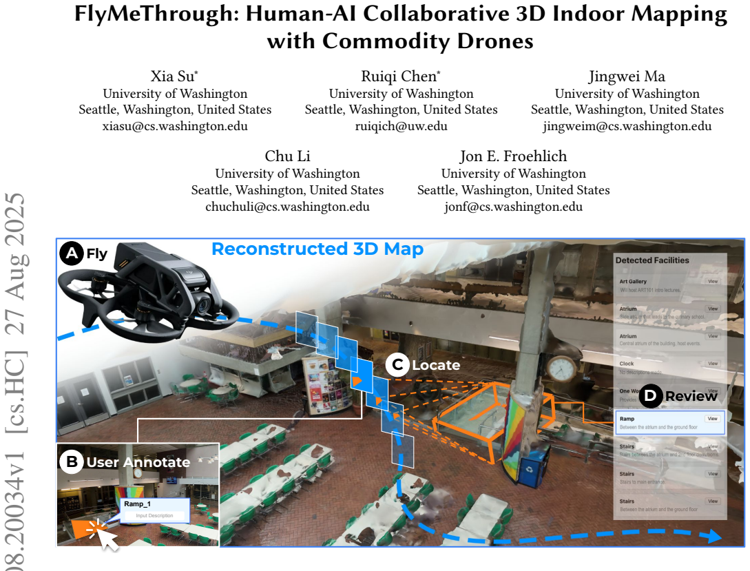
The paper's central claim is that affordable indoor 3D mapping does not need LiDAR if humans contribute small amounts of situated knowledge. After a commodity drone records RGB video, SfM reconstructs the space; the user clicks on objects of interest in a frame; SAM2 propagates each click into video masks; monocular depth extrudes the masks into point clouds; and a depth-guided ray-casting routine scales each cloud until 22% of its points meet the mesh, producing clustered, PCA-aligned 3D bounding boxes. This whole-cloud casting replaces per-pixel ray casting and is the key to suppressing mesh holes and noise. Because annotations are user-defined rather than drawn from a fixed detector vocab
What carries the argument
Depth-guided ray casting: a user's segmentation mask is turned into a 3D point cloud using monocular depth estimates, then iteratively expanded by a factor of 1.01 until 22% of its points intersect the SfM mesh; the intersections are clustered with DBSCAN and wrapped in a PCA minimum-volume bounding box. This step carries the argument because it converts 2D user clicks into localized, sized 3D POI boxes without any depth sensor.
Load-bearing premise
The system's locating accuracy depends on a fixed 22% intersection threshold and on monocular depth estimates preserving object shape; neither has been checked against measured true positions or on spaces not used to tune it.
What would settle it
Measure the true positions and sizes of doors, stairs, and elevators in a building that was not part of the 12 test spaces, run FlyMeThrough on a drone flight of that building, and compare the resulting 3D bounding boxes to tape-measure ground truth. If the mean placement error is large or the 22% threshold fails to converge on objects, the claim that the system can precisely create indoor 3D maps fails.
If this is right
- Any consumer drone with at least a 12MP camera and 30FPS video can be used, dropping the hardware cost of indoor mapping from professional LiDAR setups to a few hundred dollars.
- Building managers can maintain up-to-date 3D inventories of their spaces without professional scanning services, re-scanning whenever layouts change.
- Maps can be tailored per use: one version for fire safety and equipment, another for navigation and accessibility, because annotation is user-defined rather than fixed-category.
- Remote inspection, event planning, and training can happen from the 3D map, reducing the need for site visits.
- The modular pipeline is forward-compatible: better reconstruction methods, better depth models, or real depth sensors can be swapped in without redesigning the workflow.
Where Pith is reading between the lines
- The fixed 22% intersection threshold is likely the least transferable part; an adaptive threshold or explicit metric-scale estimation validated against ground truth would determine whether the approach generalizes beyond the 12 tested spaces.
- The workflow could shift from human-initiated to human-verified annotation: an open-vocabulary detector proposes candidate POIs and users confirm or correct them, cutting per-annotation time below the observed 41 seconds.
- Combining this pipeline with autonomous flight planning could enable regularly scheduled, low-cost digital twin updates; the paper names this as future work.
- The reconstruction failure in the circular, repetitive corridor (S9) suggests that feature-matching limits in SfM, not drone cost, are the next scaling barrier; loop-closure-aware methods would be the targeted fix.
Editorial analysis
A structured set of objections, weighed in public.
Referee Report
Summary. FlyMeThrough is an end-to-end RGB-only drone-based indoor mapping system presented as a human-AI collaborative workflow. The pipeline combines Agisoft Metashape SfM reconstruction, SAM2-based interactive annotation, and a new depth-guided ray-casting algorithm that scales monocular-depth point clouds until a threshold fraction of points intersects the reconstructed mesh, then clusters intersection points to produce 3D bounding boxes for points of interest. The system is evaluated on 12 real indoor spaces (11 successful reconstructions), with a user study involving 5 building managers and 5 building occupants who annotated 158 POIs. The paper reports that 91.77% of annotations were successfully cast to 3D bounding boxes and that participants rated bounding boxes as accurate 71.54% of the time. From these results the authors claim that FlyMeThrough can 'efficiently and precisely create indoor 3D maps.'
Significance. If the precision claim were substantiated, this would be a useful contribution: it lowers the hardware barrier for indoor 3D mapping to commodity RGB drones, introduces a flexible human-in-the-loop annotation workflow that supports open-vocabulary POI types, and provides an open-sourced, modular implementation. The 12-space deployment and the stakeholder study with building managers and occupants are concrete strengths, and the 11/12 reconstruction success and 91.77% annotation-casting rate support feasibility and throughput. The weak point is geometric validation: no direct measurement of bounding-box location or dimension accuracy is reported, and the localization algorithm's key threshold is fitted on the evaluation data, so the word 'precisely' in the abstract is not empirically established by the current evaluation.
major comments (2)
- [§5.4, §5.5.2, Abstract] The abstract's central claim that FlyMeThrough 'precisely' creates indoor 3D maps is not supported by any ground-truth geometric evaluation. Reconstruction success rates and annotation-casting rates in §5.4 are binary/throughput measures, not accuracy measures. The only precision-related evidence is the self-reported participant rating in §5.5.2: 'average percentage of objects rated as accurate was 71.54% (SD=29.73%)'. Because participants rated boxes for objects they themselves annotated and there is no independent measurement of the boxes' centers, extents, or orientations relative to the real objects, this is not an objective validation of placement accuracy. I recommend adding a direct geometric evaluation (e.g., compare a sample of bounding boxes to manual or laser-scanned ground truth and report center/edge errors in meters), or tempering the precision claim accordingly.
- [§3.4, §5.4] The depth-guided ray-casting stopping rule is 'currently set as a fixed 22% based on experiments' (§3.4). This threshold is a free parameter fitted to the same data on which the 91.77% casting-success rate (§5.4) is reported, so the reported success partly reflects tuning rather than independent generalization. No sensitivity analysis or held-out validation is given, and the iterative 1.01 scale increments plus the unknown scale of the monocular depth cloud leave the placement accuracy dependent on the first scale at which the 22% crossing occurs. I recommend: (a) sweeping the threshold and reporting casting success and placement error as functions of the threshold; (b) validating the chosen threshold on held-out spaces; and (c) reporting the scale factors actually reached, so readers can judge whether the final boxes are metrically plausible.
minor comments (4)
- [§6.6] The PSNR comparison is not informative as presented. 'Comparing the reconstruction results with the raw input images' is ambiguous about the protocol (which views, how many, aligned how?), the PSNR values lack variance, and the cited range from Burde et al. comes from a different task and dataset. Since the paper's claim is about geometric precision, an image-space PSNR is not a substitute; this paragraph should be revised or moved to a limitations/discussion context.
- [§3.4] Minor terminology: 'correlation portion' appears to mean 'proportion' of points that intersect the mesh. Also consider clarifying that Depth Pro returns relative rather than metric depth in this pipeline, since the model itself is often described as metric; the paper's statement about an 'unknown global scale factor' should be made consistent with the cited Depth Pro behavior.
- [§5.1] Typo: 'The session concluds' should be 'concludes'.
- [Table 1] The 'Reconstruction Status' column is a binary 'Good/Failed' label without any quantitative mesh-quality criterion. Providing a simple metric (e.g., track length, dense point count, or image coverage) would help readers interpret the 11/12 success rate.
Circularity Check
No circularity: the central pipeline is implemented from external components; the 22% threshold is a validation concern, not a definitional loop.
full rationale
The derivation chain (RGB video → SfM reconstruction → SAM2 segmentation → depth-guided raycasting → 3D bounding boxes → user evaluation) is not circular. The only element that might appear circular is the 22% intersection threshold in §3.4, described as 'currently set as a fixed 22% based on experiments.' This is a tuned stopping rule, and the reported '91.77% of all annotations were successfully cast into bounding boxes' is measured on the same spaces used to set the rule. However, the paper does not present that success rate as a prediction of localization accuracy; it is an operational description of how often the pipeline reached its own stopping condition, with failures attributed to missing camera parameters or incomplete SfM geometry. The 'precisely' claim in the abstract rests on the user-study rating that 71.54% of bounding boxes were judged accurate—a subjective but independent judgment about the output, not a quantity forced by the threshold. Equations (1) and (2) are standard pinhole projection; the iterative scaling is a heuristic with no assertion that it is derived from first principles. Self-citations to prior work [59, 60] are for related baselines and settings, not load-bearing, and there is no imported uniqueness theorem or ansatz. The unvalidated 22% threshold and the absence of ground-truth object-position comparison are legitimate correctness/validity concerns, but they do not amount to circularity under the definitions used here. Therefore no significant circularity is found.
Axiom & Free-Parameter Ledger
free parameters (3)
- Mesh intersection threshold =
22%
- Point cloud scale increment base =
1.01
- DBSCAN parameters =
not reported
axioms (4)
- domain assumption SfM camera poses and mesh are globally consistent and sufficiently metrically accurate for POI localization
- domain assumption Monocular depth estimates (Depth Pro) preserve relative object shape and orientation across frames
- domain assumption SAM2 masks remain temporally consistent and pixel-accurate for user-defined objects
- ad hoc to paper The fixed 22% intersection threshold generalizes to new indoor spaces
Cite this review
Pith. "Pith review of FlyMeThrough: Human-AI Collaborative 3D Indoor Mapping with Commodity Drones." pith.science (2026). https://pith.science/paper/6VO5SKG2
@misc{pith2026250820034,
  author       = {Pith},
  title        = {Pith review of: FlyMeThrough: Human-AI Collaborative 3D Indoor Mapping with Commodity Drones},
  year         = {2026},
  howpublished = {\url{https://pith.science/paper/6VO5SKG2}},
  note         = {Machine review of arXiv:2508.20034}
}
read the original abstract
Indoor mapping data is crucial for routing, navigation, and building management, yet such data are widely lacking due to the manual labor and expense of data collection, especially for larger indoor spaces. Leveraging recent advancements in commodity drones and photogrammetry, we introduce FlyMeThrough -- a drone-based indoor scanning system that efficiently produces 3D reconstructions of indoor spaces with human-AI collaborative annotations for key indoor points-of-interest (POI) such as entrances, restrooms, stairs, and elevators. We evaluated FlyMeThrough in 12 indoor spaces with varying sizes and functionality. To investigate use cases and solicit feedback from target stakeholders, we also conducted a qualitative user study with five building managers and five occupants. Our findings indicate that FlyMeThrough can efficiently and precisely create indoor 3D maps for strategic space planning, resource management, and navigation.
Figures


Reference graph
Works this paper leans on
-
[1]
[n. d.]. Capture, share, and collaborate the built world in immersive 3D. https: //matterport.com/
-
[2]
Meta AI. 2024. Segment Anything Model 2 (SAM2). https://github.com/ facebookresearch/sam2. Accessed: 2025-04-06
2024
-
[3]
Stanislav Alexovič, Milan Lacko, and Ján Bačík. 2023. 3D Mapping with a Drone Equipped with a Depth Camera in Indoor Environment. Acta Electrotechnica et Informatica 23, 1 (2023), 18–24
2023
-
[4]
Mohammed Eunus Ali, Muhammad Aamir Cheema, Tanzima Hashem, Anwaar Ulhaq, and Muhammad Ali Babar. 2024. Enabling spatial digital twins: Technolo- gies, challenges, and future research directions. PFG–Journal of Photogrammetry, Remote Sensing and Geoinformation Science (2024), 1–18
work page 2024
-
[5]
Apple. 2022. RoomPlan - Augmented Reality. https://developer.apple.com/ augmented-reality/roomplan/
work page 2022
-
[6]
Aleksei Bochkovskii, AmaÃG, l Delaunoy, Hugo Germain, Marcel Santos, Yichao Zhou, Stephan R Richter, and Vladlen Koltun. 2024. Depth pro: Sharp monocular metric depth in less than a second. arXiv preprint arXiv:2410.02073 (2024)
Pith/arXiv arXiv 2024
-
[7]
Varun Burde, Assia Benbihi, Pavel Burget, and Torsten Sattler. 2025. Comparative Evaluation of 3D Reconstruction Methods for Object Pose Estimation. In 2025 IEEE/CVF Winter Conference on Applications of Computer Vision (W ACV). IEEE, 7669–7681
work page 2025
-
[8]
Kathy Charmaz. 2006. Constructing grounded theory: A practical guide through qualitative analysis. sage
work page 2006
-
[9]
Yuwei Chen, Jian Tang, Changhui Jiang, Lingli Zhu, Matti Lehtomäki, Harri Kaartinen, Risto Kaijaluoto, Yiwu Wang, Juha Hyyppä, Hannu Hyyppä, et al
-
[10]
Yixin Chen, Guoxi Zhang, Yaowei Zhang, Hongming Xu, Peiyuan Zhi, Qing Li, and Siyuan Huang. 2024. SYNERGAI: Perception Alignment for Human-Robot Collaboration. arXiv preprint arXiv:2409.15684 (2024)
work page internal anchor Pith review Pith/arXiv arXiv 2024
-
[11]
Cupix Inc. 2025. Cupix: 3D Digital Twin Solutions. https://www.cupix.com. Accessed: 2025-04-06
work page 2025
-
[12]
Darko Dimitrov, Christian Knauer, Klaus Kriegel, and Günter Rote. 2006. On the bounding boxes obtained by principal component analysis. In 22nd European Workshop on Computational Geometry. 193–196
work page 2006
-
[13]
Esri. 2025. ArcGIS Indoors: Indoor Mapping and Space Management. https: //www.esri.com/en-us/arcgis/products/arcgis-indoors/overview Accessed: 2025- 02-14
work page 2025
-
[14]
Martin Ester, Hans-Peter Kriegel, Jörg Sander, Xiaowei Xu, et al. 1996. A density- based algorithm for discovering clusters in large spatial databases with noise. In kdd, Vol. 96. 226–231
1996
- [15]
-
[16]
Flyability. 2025. Elios 3: The Ultimate Indoor Drone for Inspection and Mapping. https://www.flyability.com/elios-3 Accessed: 2025-02-14
work page 2025
-
[17]
Chuanxiang Gao, Xinyi Wang, Xi Chen, and Ben M Chen. 2024. A hierarchical multi-UAV cooperative framework for infrastructure inspection and reconstruc- tion. Control Theory and Technology 22, 3 (2024), 394–405
work page 2024
-
[18]
Chuanxiang Gao, Xinyi Wang, Ruoyu Wang, Zuoquan Zhao, Yu Zhai, Xi Chen, and Ben M Chen. 2023. A UAV-based explore-then-exploit system for autonomous indoor facility inspection and scene reconstruction. Automation in Construction 148 (2023), 104753
work page 2023
-
[19]
Alain Hore and Djemel Ziou. 2010. Image quality metrics: PSNR vs. SSIM. In 2010 20th international conference on pattern recognition . IEEE, 2366–2369
work page 2010
-
[20]
Liubo Hou, Zhongliang Deng, Boyang Lou, Xiangyu Zhen, and Licheng Wei
-
[21]
Dongki Jung, Jaehoon Choi, Yonghan Lee, and Dinesh Manocha. 2025. IM360: Textured Mesh Reconstruction for Large-scale Indoor Mapping with 360◦ Cam- eras. arXiv:2502.12545 [cs.CV] https://arxiv.org/abs/2502.12545
arXiv 2025
-
[22]
Samer Karam, Francesco Nex, Bhanu Teja Chidura, and Norman Kerle. 2022. Microdrone-based indoor mapping with graph slam. Drones 6, 11 (2022), 352. FlyMeThrough
work page 2022
-
[23]
S Karam, F Nex, O Karlsson, J Rydell, E Bilock, M Tulldahl, M Holmberg, and N Kerle. 2022. Micro and macro quadcopter drones for indoor mapping to support disaster management. ISPRS Annals of the Photogrammetry, Remote Sensing and Spatial Information Sciences 1 (2022), 203–210
work page 2022
-
[24]
Bernhard Kerbl, Georgios Kopanas, Thomas Leimkühler, and George Drettakis
-
[25]
Maksim Kolodiazhnyi, Anna Vorontsova, Matvey Skripkin, Danila Rukhovich, and Anton Konushin. 2024. UniDet3D: Multi-dataset Indoor 3D Object Detection. arXiv preprint arXiv:2409.04234 (2024)
work page internal anchor Pith review Pith/arXiv arXiv 2024
-
[26]
Justin Lazarow, David Griffiths, Gefen Kohavi, Francisco Crespo, and Afshin Dehghan. 2024. Cubify Anything: Scaling Indoor 3D Object Detection. arXiv preprint arXiv:2412.04458 (2024)
Pith/arXiv arXiv 2024
-
[27]
Fangyu Li, Sisi Zlatanova, Martijn Koopman, Xueying Bai, and Abdoulaye Diakité
-
[28]
Xinlei Liu, Kevin Wu, Minchu Kulkarni, Michael Saugstad, Peyton Anton Rapo, Jeremy Freiburger, Maryam Hosseini, Chu Li, and Jon E Froehlich. 2024. Towards Fine-Grained Sidewalk Accessibility Assessment with Deep Learning: Initial Benchmarks and an Open Dataset. In Proceedings of the 26th International ACM SIGACCESS Conference on Computers and Accessibility . 1–12
work page 2024
-
[29]
Luma AI. 2025. Luma AI: AI Video and 3D Capture Solutions. https://lumalabs.ai/. Accessed: 2025-04-06
work page 2025
-
[30]
Mehdi Maboudi, MohammadReza Homaei, Soohwan Song, Shirin Malihi, Mo- hammad Saadatseresht, and Markus Gerke. 2023. A review on viewpoints and path planning for UAV-based 3-D reconstruction. IEEE Journal of Selected Topics in Applied Earth Observations and Remote Sensing 16 (2023), 5026–5048
work page 2023
-
[31]
Automation in Construction 95 (2018), 275–283
Universal path planning for an indoor drone. Automation in Construction 95 (2018), 275–283
work page 2018
-
[32]
Aman Malhotra and Ulrik Söderström. 2022. Fixed camera drone based pho- togrammetry for indoor mapping. In 2022 IEEE 9th Uttar Pradesh Section Interna- tional Conference on Electrical, Electronics and Computer Engineering (UPCON) . IEEE, 1–5
work page 2022
-
[33]
Mappedin Inc. 2025. Mappedin: Indoor Mapping and Navigation Platform. https: //www.mappedin.com. Accessed: 2025-04-06
work page 2025
-
[34]
Mapsted Inc. 2025. Mapsted: Indoor Positioning and Navigation Solutions. https: //mapsted.com. Accessed: 2025-04-06
work page 2025
-
[35]
Dominic Maggio, Hyungtae Lim, and Luca Carlone. 2025. Vggt-slam: Dense rgb slam optimized on the sl (4) manifold. arXiv preprint arXiv:2505.12549 (2025)
Pith/arXiv arXiv 2025
-
[36]
Ben Mildenhall, Pratul P Srinivasan, Matthew Tancik, Jonathan T Barron, Ravi Ramamoorthi, and Ren Ng. 2021. Nerf: Representing scenes as neural radiance fields for view synthesis. Commun. ACM 65, 1 (2021), 99–106
2021
-
[37]
Riku Murai, Eric Dexheimer, and Andrew J. Davison. 2024. MASt3R-SLAM: Real-Time Dense SLAM with 3D Reconstruction Priors. arXiv preprint (2024)
work page 2024
-
[38]
NavVis GmbH. 2025. NavVis: Indoor Mapping and Navigation Solutions. https: //www.navvis.com. Accessed: 2025-04-06
work page 2025
-
[39]
Rachel McAmis and Tadayoshi Kohno. 2023. The Writing on the Wall and 3D Dig- ital Twins: Personal Information in (not so) Private Real Estate. In 32nd USENIX Security Symposium (USENIX Security 23) . USENIX Association, Anaheim, CA, 2169–2186. https://www.usenix.org/conference/usenixsecurity23/presentation/ mcamis
work page 2023
-
[40]
Onur Özyeşil, Vladislav Voroninski, Ronen Basri, and Amit Singer. 2017. A survey of structure from motion*. Acta Numerica 26 (2017), 305–364
work page 2017
-
[41]
Georgios Pipelidis, Christian Prehofer, and Ilias Gerostathopoulos. 2019. Boot- strapping the dynamic generation of indoor maps with crowdsourced smart- phone sensor data. In Geographical Information Systems Theory, Applications and Management: Third International Conference, GISTAM 2017, Porto, Portugal, April 27–28, 2017, Revised Selected Papers 3 . Spr...
work page 2019
-
[42]
Pointr. 2025. Pointr: Indoor Location Technology. https://www.pointr.tech/ Accessed: 2025-02-14
work page 2025
-
[43]
Jin-Si R Over, Andrew C Ritchie, Christine J Kranenburg, Jenna A Brown, Daniel D Buscombe, Tom Noble, Christopher R Sherwood, Jonathan A Warrick, and Phillipe A Wernette. 2021. Processing coastal imagery with Agisoft Metashape Professional Edition, version 1.6—Structure from motion workflow documentation . Technical Report. US Geological Survey
work page 2021
-
[44]
Nikhila Ravi, Valentin Gabeur, Yuan-Ting Hu, Ronghang Hu, Chaitanya Ryali, Tengyu Ma, Haitham Khedr, Roman Rädle, Chloe Rolland, Laura Gustafson, Eric Mintun, Junting Pan, Kalyan Vasudev Alwala, Nicolas Carion, Chao-Yuan Wu, Ross Girshick, Piotr Dollár, and Christoph Feichtenhofer. 2024. SAM 2: Segment Anything in Images and Videos. arXiv preprint arXiv:2...
Pith/arXiv arXiv 2024
-
[45]
David Rhind. 1988. A GIS research agenda. International Journal of Geographical information system 2, 1 (1988), 23–28
work page 1988
-
[46]
Dávid Rozenberszki, Gábor Sörös, Szilvia Szeier, and András Lőrincz. 2021. 3d se- mantic label transfer in human-robot collaboration. InProceedings of the IEEE/CVF International Conference on Computer Vision . 2602–2611
work page 2021
-
[47]
Polycam. [n. d.]. Polycam. https://poly.cam/. Accessed: 2024-07-02
work page 2024
-
[48]
Tejaswi Samavedula, Satyajit Mohapatra, and Sanjeet Kumar Nayak. 2025. Mini Mapper: Cost-Effective Indoor Mapping and Navigation using Nano Drone. In 2025 17th International Conference on COMmunication Systems and NET- works (COMSNETS). 1377–1379. https://doi.org/10.1109/COMSNETS63942.2025. 10885580
arXiv 2025
-
[49]
Johannes Lutz Schönberger and Jan-Michael Frahm. 2016. Structure-from-Motion Revisited. In Conference on Computer Vision and Pattern Recognition (CVPR)
work page 2016
-
[50]
Johannes L Schonberger and Jan-Michael Frahm. 2016. Structure-from-motion revisited. In Proceedings of the IEEE conference on computer vision and pattern recognition. 4104–4113
work page 2016
-
[51]
Manaswi Saha, Michael Saugstad, Hanuma Teja Maddali, Aileen Zeng, Ryan Holland, Steven Bower, Aditya Dash, Sage Chen, Anthony Li, Kotaro Hara, et al
-
[52]
Johannes Lutz Schönberger, Enliang Zheng, Marc Pollefeys, and Jan-Michael Frahm. 2016. Pixelwise View Selection for Unstructured Multi-View Stereo. In European Conference on Computer Vision (ECCV)
work page 2016
-
[53]
Guanlin Shen, Jingwei Huang, Zhihua Hu, and Bin Wang. 2024. Cn-rma: Com- bined network with ray marching aggregation for 3d indoor object detection from multi-view images. In Proceedings of the IEEE/CVF Conference on Computer Vision and Pattern Recognition . 21326–21335
work page 2024
-
[54]
Manli Shu, Le Xue, Ning Yu, Roberto Martín-Martín, Caiming Xiong, Tom Gold- stein, Juan Carlos Niebles, and Ran Xu. 2024. Hierarchical Point Attention for Indoor 3D Object Detection. In 2024 IEEE International Conference on Robotics and Automation (ICRA). IEEE, 4245–4251
work page 2024
-
[55]
Skydio. 2025. Introducing 3D Indoor Capture. https://www.skydio.com/blog/ introducing-3d-indoor-capture Accessed: 2025-02-14
work page 2025
-
[56]
Johannes L Schönberger, Enliang Zheng, Jan-Michael Frahm, and Marc Pollefeys
-
[57]
Peter Sturm. 2021. Pinhole camera model. In Computer Vision: A Reference Guide . Springer, 983–986
work page 2021
-
[58]
Xia Su, Daniel Campos Zamora, and Jon E Froehlich. 2024. RAIS: Towards A Robotic Mapping and Assessment Tool for Indoor Accessibility Using Commodity Hardware. In Proceedings of the 26th International ACM SIGACCESS Conference on Computers and Accessibility . 1–5
work page 2024
-
[59]
Xia Su, Ruiqi Chen, Weiye Zhang, Jingwei Ma, and Jon E Froehlich. 2024. A Demo of DIAM: Drone-based Indoor Accessibility Mapping. In Adjunct Proceedings of the 37th Annual ACM Symposium on User Interface Software and Technology . 1–3
work page 2024
-
[60]
Xia Su, Han Zhang, Kaiming Cheng, Jaewook Lee, Qiaochu Liu, Wyatt Olson, and Jon E Froehlich. 2024. RASSAR: Room Accessibility and Safety Scanning in Augmented Reality. In Proceedings of the CHI Conference on Human Factors in Computing Systems. 1–17
work page 2024
-
[61]
Matthew Tancik, Ethan Weber, Evonne Ng, Ruilong Li, Brent Yi, Terrance Wang, Alexander Kristoffersen, Jake Austin, Kamyar Salahi, Abhik Ahuja, et al. 2023. Nerfstudio: A modular framework for neural radiance field development. InACM SIGGRAPH 2023 conference proceedings . 1–12
work page 2023
-
[62]
Xu Song, Xuan Liang, and Zhou Huaidong. 2025. Semantic mapping techniques for indoor mobile robots: Review and prospect. Measurement and Control 58, 3 (2025), 377–393
work page 2025
-
[63]
Zachary Teed and Jia Deng. 2021. Droid-slam: Deep visual slam for monocular, stereo, and rgb-d cameras. Advances in neural information processing systems 34 (2021), 16558–16569
2021
-
[64]
Ultralytics. 2023. YOLOv8: Cutting-edge object detection. https://github.com/ ultralytics/ultralytics. Accessed: 2025-04-06
work page 2023
-
[65]
Jiangyi Wang and Na Zhao. 2025. Uncertainty Meets Diversity: A Comprehensive Active Learning Framework for Indoor 3D Object Detection. arXiv preprint arXiv:2503.16125 (2025)
work page internal anchor Pith review Pith/arXiv arXiv 2025
- [66]
-
[67]
Galen Weld, Esther Jang, Anthony Li, Aileen Zeng, Kurtis Heimerl, and Jon E Froehlich. 2019. Deep learning for automatically detecting sidewalk accessibility problems using streetscape imagery. In Proceedings of the 21st International ACM SIGACCESS Conference on Computers and Accessibility . 196–209
work page 2019
-
[68]
Zhenggang Tang, Yuchen Fan, Dilin Wang, Hongyu Xu, Rakesh Ranjan, Alexan- der Schwing, and Zhicheng Yan. 2024. MV-DUSt3R+: Single-Stage Scene Re- construction from Sparse Views In 2 Seconds. arXiv preprint arXiv:2412.06974 (2024)
Pith/arXiv arXiv 2024
-
[69]
Mingxu Yang, Chuhua Huang, Xin Huang, and Shengjin Hou. 2025. Privacy- Preserved Visual Simultaneous Localization and Mapping Based on a Dual- Component Approach. Applied Sciences 15, 5 (2025), 2583
work page 2025
-
[70]
Han Yue and Hangbin Wu. 2018. Update Method of Indoor Maps Based on Volunteered Geographic Information (VGI). In 2018 26th International Conference on Geoinformatics. IEEE, 1–5. Xia Su, Ruiqi Chen, Jingwei Ma, Chu Li, and Jon E. Froehlich
work page 2018
- [71]
-
[72]
Jing Zeng, Qi Ye, Tianle Liu, Yang Xu, Jin Li, Jinming Xu, Liang Li, and Jiming Chen. 2024. Multi-robot autonomous 3D reconstruction using Gaussian splatting with Semantic guidance. arXiv preprint arXiv:2412.02249 (2024)
work page internal anchor Pith review Pith/arXiv arXiv 2024
-
[73]
Hao Xuan Zhang, Yilin Yang, and Zhengbo Zou. 2024. ICON drone: Autonomous indoor exploration using Unmanned Aerial Vehicle for semantic 3D reconstruc- tion. In Proceedings of the 11th ACM International Conference on Systems for Energy-Efficient Buildings, Cities, and Transportation . 66–76
work page 2024
-
[74]
Yating Xu, Chen Li, and Gim Hee Lee. 2024. MVSDet: Multi-View Indoor 3D Ob- ject Detection via Efficient Plane Sweeps. InThe Thirty-eighth Annual Conference on Neural Information Processing Systems
work page 2024
-
[75]
Guyue Zhou, Ang Liu, Kang Yang, Tao Wang, and Zexiang Li. 2014. An embedded solution to visual mapping for consumer drones. In Proceedings of the IEEE Conference on Computer Vision and Pattern Recognition Workshops . 656–661
work page 2014
-
[76]
Rui Zhu, Cogan Shimizu, Shirly Stephen, Colby K Fisher, Thomas Thelen, Kitty Currier, Krzysztof Janowicz, Pascal Hitzler, Mark Schildhauer, Wenwen Li, et al
-
[80]
Xiaohong Zhang, Huisheng Ye, Jingwen Li, Qinyu Tang, Yuanqi Li, Yanwen Guo, and Jie Guo. 2024. Prompt3D: Random Prompt Assisted Weakly-Supervised 3D Object Detection. In Proceedings of the IEEE/CVF Conference on Computer Vision and Pattern Recognition. 28046–28055
work page 2024
-
[2016]
Pixelwise view selection for unstructured multi-view stereo. In Com- puter Vision–ECCV 2016: 14th European Conference, Amsterdam, The Netherlands, October 11-14, 2016, Proceedings, Part III 14 . Springer, 501–518
work page 2016
-
[2018]
The accuracy comparison of three simultaneous localization and mapping (SLAM)-based indoor mapping technologies. Sensors 18, 10 (2018), 3228
work page 2018
-
[2019]
In Proceedings of the 2019 CHI Conference on Human Factors in Computing Systems
Project sidewalk: A web-based crowdsourcing tool for collecting sidewalk accessibility data at scale. In Proceedings of the 2019 CHI Conference on Human Factors in Computing Systems . 1–14
work page 2019
This paper was first reviewed by deepseek-v4-flash on August 5, 2026.
discussion (0)
Sign in with ORCID, Apple, or X to comment. Anyone can read and Pith papers without signing in.