REVIEW 3 major objections 6 minor 67 references
A Bayesian High-Resolution Transformer can map pan-Arctic sea ice concentration at 200 m resolution with calibrated uncertainty, using geographically-weighted weak supervision and decision-level fusion of Sentinel-1, RCM, and AMSR2 data.
Reviewed by Pith at T0; open to challenge. T0 means a machine referee read the full paper against a public rubric. the ladder, T0–T4 →
T0 review · deepseek-v4-flash
2026-08-02 19:04 UTC pith:PHN47G2E
load-bearing objection Solid engineering with one genuinely external validation (R²=0.90 vs ASI), but the headline feature-detection and ECE results are partly circular because they are measured against the same NIC and NASA Team products used in training. the 3 major comments →
Geographically-Weighted Weakly Supervised Bayesian High-Resolution Transformer for 200m Resolution Pan-Arctic Sea Ice Concentration Mapping and Uncertainty Estimation using Sentinel-1, RCM, and AMSR2 Data
The pith
A machine-rendered reading of the paper's core claim, the machinery that carries it, and where it could break.
Core claim
On the paper's own terms, the central claim is that a high-resolution Transformer with separate global and local attention modules, trained with a geographically-weighted weakly supervised L1 loss and endowed with Bayesian parameter distributions, produces pan-Arctic SIC maps at 200 m spatial resolution that preserve large-scale SIC patterns (R²=0.90 relative to ASI) and detect small features such as leads and floes (0.70 overall ice/water accuracy on Sentinel-1). The same uncertainty estimates are better calibrated than MC dropout or epoch ensembles, with the lowest ECE and standard deviations (0.01–0.33%) for Sentinel-1.
What carries the argument
The load-bearing pieces are: (1) a high-resolution Transformer built from a GloFormer (global among-token attention) and a LoFormer (local within-token attention) stacked four times; (2) a geographically-weighted weakly supervised L1 loss that averages predicted SIC within NASA Team concentration clusters and weights samples by the NIC ice chart, down-weighting the marginal ice zone; (3) a Bayes-by-Backpropagation treatment that places a Gaussian distribution over attention parameters and adds a KL loss, giving predictive means and variances from 30 variational inferences; and (4) decision-level fusion that layers Sentinel-1 over RCM over AMSR2 89.0 GHz estimates.
Load-bearing premise
The feature-detection evaluation assumes that adaptive thresholding of the NIC ice chart produces reliable ice/water binary masks at 200 m resolution, and that the 300 manually selected samples faithfully represent the difficulty of the mapping task; since the same charts also set the training weights, the 0.70 accuracy may not be independent of the training signal.
What would settle it
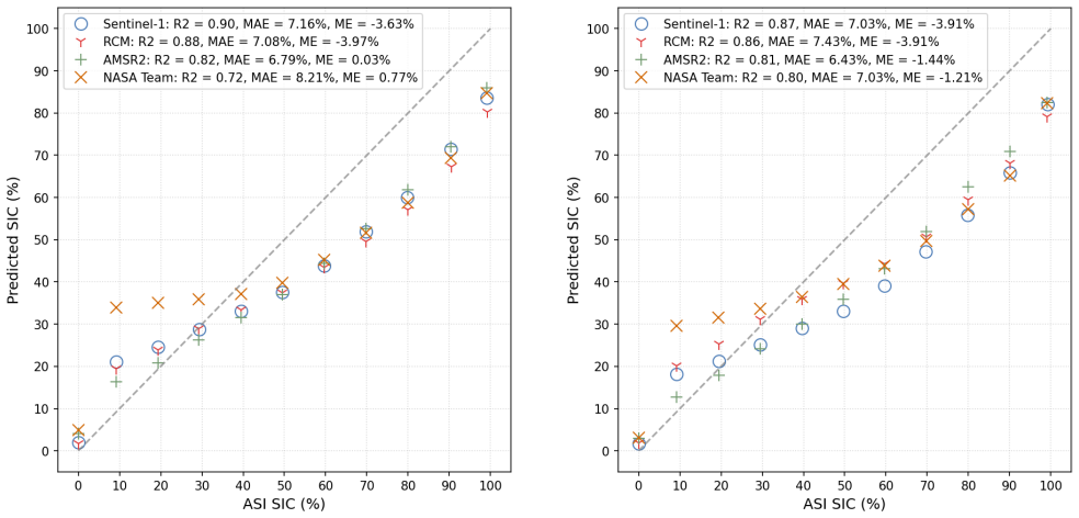
Take the three validation dates and compare the model's predicted 200 m ice/water boundaries against Sentinel-2 (or other) 10 m optical imagery with manual ice/water labelling. If the 0.70 overall accuracy does not survive when the reference masks are derived from independent high-resolution imagery rather than from adaptive-thresholded NIC charts, the claim that the model resolves 200 m features is weakened. A second check: compute the R² against an ASI product derived from a different sensor (e.g., SSMIS) to rule out AMSR2 circularity.
If this is right
- If correct, the approach yields 200 m pan-Arctic SIC maps with daily coverage when SAR is available, enabling detection of leads and floes that are invisible in ~3–12 km passive-microwave products.
- The geographically-weighted weak supervision suggests a general recipe for training high-resolution models from coarse, location-dependent labels: weight by the reliability of the label region rather than assuming uniform pixel accuracy.
- The Bayesian calibration result implies that operational ice products could carry per-pixel uncertainty estimates that are statistically consistent with residuals, which is required for data assimilation and ice forecasting.
- The decision-level fusion framework provides a simple way to combine heterogeneous sensors without forcing them into a common feature space.
Where Pith is reading between the lines
- A testable extension would be to validate the 200 m feature claims against independent very-high-resolution imagery (e.g., 10 m optical) on the same dates; the current 0.70 accuracy is measured against adaptive-thresholded NIC charts, which are themselves region-level manual products and also set the training weights, so the metric may partly reflect the training signal.
- If the geographically-weighted weighting is doing the work, then the method should be especially sensitive to the NIC chart quality in the MIZ; a perturbation study that shuffles or removes the MIZ weighting would separate the contribution of weak supervision from that of the architecture.
- The model is trained only on September minimum-extent dates; a natural next step is to test whether the same architecture transfers across freeze-up and melt seasons, or whether separate seasonal experts are needed.
Editorial analysis
A structured set of objections, weighed in public.
Referee Report
Summary. The manuscript presents a Bayesian High-Resolution Transformer for 200 m resolution pan-Arctic sea ice concentration (SIC) mapping from Sentinel-1, RCM, and AMSR2. The architecture combines a global among-token transformer (GloFormer) and a local within-token transformer (LoFormer). Training uses a geographically-weighted weakly supervised L1 loss: the model is supervised at SIC-cluster level against NASA Team SIC, with sample weights derived from NIC ice charts. Bayesian inference is implemented via Bayes-by-Backpropagation, and compared with MC dropout and epoch ensembles. Decision-level fusion layers Sentinel-1 over RCM and AMSR2 SIC/uncertainty maps. The paper reports 0.70 overall feature detection accuracy for Sentinel-1, R²=0.90 against the ASI product after downsampling, and lower ECE for the Bayesian model.
Significance. If the results are accepted, the paper would offer one of the first demonstrations of 200 m pan-Arctic SIC mapping with formal Bayesian uncertainty quantification, and a practical decision-level fusion scheme. The manuscript has solid internal methodology: the loss and Bayesian objectives are standard, the comparison against MC dropout and epoch ensembles is systematic, and ablations on LoFormer and the geographic weighting are helpful. The ASI-based pan-Arctic R² is an independent check at coarse scale. However, the two signature quantitative claims — 0.70 feature detection accuracy and superior calibration — rely on evaluation references that overlap with the training signals (NIC chart and NASA Team SIC), so the central evidence needs re-evaluation before the claims can be accepted.
major comments (3)
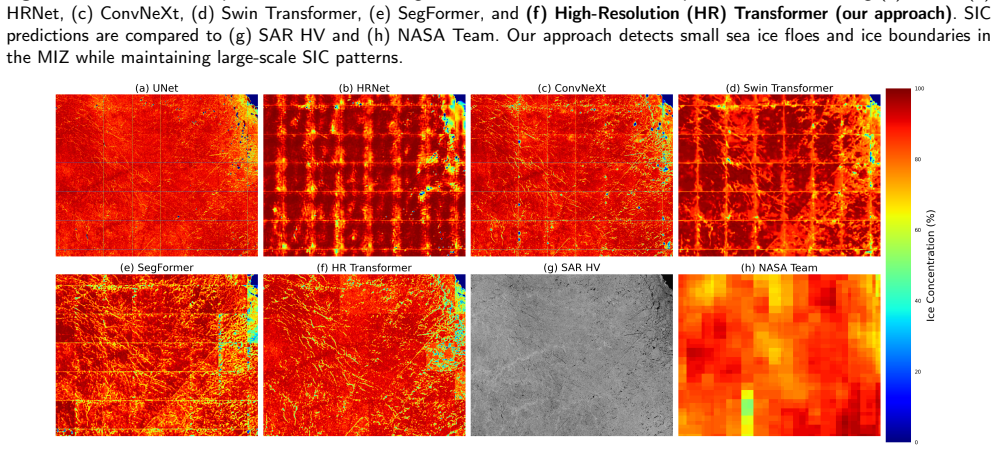
- [§4.7.2, Table 5; §4.2, Eq. (5)] The headline feature-detection accuracy (0.70 overall, Table 5) is evaluated against ice/water masks produced by adaptive thresholding of the NIC ice chart (§4.7.2), while the same NIC chart is used to define the geographical weights GW in the training loss (§4.2, Eq. (5)). Because the model is explicitly trained to assign higher weight to open-water and ice-pack regions identified from the NIC chart, agreement with a NIC-derived binary mask partially reflects the training signal rather than independent 200 m feature-resolution skill. The manual selection of 300 'high quality' samples where thresholding is accurate further risks selection bias. The authors should validate feature detection against an independent high-resolution reference (e.g., expert-delineated SAR ice/water masks) and specify that the MIZ/ice-pack thresholds are not derived from the same NIC chart used for training.
- [§5.2, Eq. (12)] The calibration claim (Bayesian Transformer ECE 0.0018–0.0028, Table 3) is computed with y_i in Eq. (12) taken from the NASA Team SIC product, which is also the weak-supervision target in the loss (Eq. (5)) and the basis for the SIC clusters in Section 4.2. Low ECE against the training label is therefore partly a measure of fit to that label, not of out-of-sample calibration. The comparison among MC dropout, ensemble, and BBB is informative only if all are evaluated against an independent reference. Please report ECE against the ASI product (with resolution-matched aggregation) or another independent reference, and state whether the ranking persists.
- [§5.3.1 and §5.5] The claimed 200 m capability is supported qualitatively by visual examples (Figs. 10–11) and by the circular feature-detection metric, while the quantitative pan-Arctic accuracy R²=0.90 is computed after averaging to the 3125 m ASI grid (§5.5). Downsampled agreement with ASI cannot substantiate detection of 1–2-pixel floes. The paper should either provide a non-circular, resolution-aware evaluation at 200 m or explicitly separate the validated coarse-scale SIC accuracy from the exploratory fine-scale feature-detection results.
minor comments (6)
- [§4.2 / Fig. 1] The numerical GW values (10, 5, 8 in Fig. 1 caption) are not defined in the text; please specify the mapping from NIC chart categories to GW and the source of these values.
- [§4.3, Eq. (8)] The sentence 'Assuming a diagonal Gaussian variational posterior, p(ω)=N(0,I)' appears to be a typo: the variational posterior should be denoted q_θ(ω), with p(ω)=N(0,I) the prior.
- [Algorithm 1] The Update operation in Algorithm 1 is undefined; please specify how the SIC and uncertainty layers are combined (overwrite, weighted average, etc.).
- [§5.3.2, Table 6] The architecture comparison is trained on a single day (2021/09/10) whereas the main results use seven training days; please clarify whether Table 6 is intended as a controlled comparison or note the different training set.
- [§4.1.1 / §4.1.2] Architectural hyperparameters (patch size, token count, number of heads, hidden dimension, MLP widths) are not stated; please provide them for reproducibility.
- [§5.5] For the AMSR2 branch, validation against the ASI product is not fully independent because both use the 89 GHz channel; state this caveat when reporting per-sensor R².
Circularity Check
Feature-detection and calibration claims are partly circular: NIC-chart weights used in training/model selection also define the evaluation masks, and ECE is computed against the NASA Team product used as training labels; only the ASI R² is independent.
specific steps
-
other
[Section 4.2 (geographically-weighted loss and validation selection) and Section 4.7.2/Section 5.3.1 (feature detection evaluation)]
"The geographically-dependent weight of each sample, GW, is determined according to the daily U.S NIC ice charts, where more confident regions like open water and ice pack are weighted higher than the less confident MIZ. ... This loss is also used to determine the best epoch during validation. ... Feature detection accuracy is assessed by manually selecting 300 high quality validation samples where adaptive thresholding of the NIC ice chart has achieved accurate ice and water binary masks."
The same NIC-chart product supplies the per-sample loss weights (including model selection on validation) and the binary ground-truth masks used to compute the headline 0.70 feature-detection accuracy. A model trained and selected to prioritize NIC-confident regions (open water/ice pack) is scored against a mask produced by thresholding that same NIC chart, with MIZ/pack thresholds also keyed to the chart's regions. The metric therefore largely measures agreement with the source that already steered training, rather than independent skill at resolving 200m-scale leads/floes.
-
fitted input called prediction
[Section 4.7.1 (ECE) vs Section 4.2 (loss on NASA Team SIC)]
"z_i=||y_i−ŷ_i||/σ_i where y_i is the NASA Team SIC, ŷ_i is the mean predicted SIC, and σ_i is the mean predicted standard deviation. ... the difference between the predicted SIC and NASA Team ground truth is measured for each SIC cluster/region instead of each high-resolution pixel."
The model's loss (Eq. 5) is minimized against cluster-level NASA Team SIC, and the same loss selects the best epoch on validation. The reported ECE (Table 3) is computed from residuals to NASA Team SIC. Hence the 'superior calibration' result is at least partly a self-consistency check against the training-label product rather than a calibration test against an independent reference. The paper's only external benchmark, ASI, is used for R²/MAE but not for ECE.
full rationale
The derivation chain is not fully circular. The architecture (GloFormer/LoFormer), the Bayesian BBB extension, the ablation studies, and the pan-Arctic accuracy comparison against the independent ASI product (R²=0.90) stand on their own and provide genuine evidence. However, two of the paper's signature evaluation quantities are measured against the same sources that steer training: the 0.70 feature-detection accuracy uses NIC-chart-derived binary masks while NIC charts also set the geographical weights and validation-based model selection; the low ECE values are computed against NASA Team SIC, the very product used as the weak supervision label. These are real but partial reductions—the model is not pixel-fitted to the evaluation masks, and the 2025 test dates are temporally held out—so the appropriate score is a moderate 5, not a higher score that would imply the entire derivation is forced.
Axiom & Free-Parameter Ledger
free parameters (6)
- Geographical weights GW (open water, ice pack, MIZ) =
Shown as GW=10, 5, 8 in Figure 1(c); not stated in text
- SIC cluster bin width =
10% SIC bins, K clusters from 0-100%
- Feature-detection thresholds =
15% SIC in MIZ, 80% in ice pack
- MC dropout rate =
10%
- Variational inference sample count =
30
- Model precision tau in likelihood =
Not specified
axioms (5)
- domain assumption NASA Team SIC product is a valid weak-supervision signal at cluster level.
- domain assumption NIC ice charts provide reliable region-level confidence and a valid basis for 200m ice/water ground truth via adaptive thresholding.
- domain assumption ASI AMSR2 product is an appropriate independent benchmark for pan-Arctic SIC.
- domain assumption Restricting Bayesian inference to attention parameters adequately captures epistemic uncertainty.
- standard math Bayes theorem, KL divergence, softmax attention are standard math.
read the original abstract
Although high-resolution mapping of pan-Arctic sea ice with reliable corresponding uncertainty is essential for operational sea ice concentration (SIC) charting, it is a difficult task due to key challenges, such as the subtle nature of ice signature features, inexact SIC labels, model uncertainty, and data heterogeneity. This study presents a novel Bayesian High-Resolution Transformer approach for 200 meter resolution pan-Arctic SIC mapping and uncertainty quantification using Sentinel-1, RADARSAT Constellation Mission (RCM), and Advanced Microwave Scanning Radiometer 2 (AMSR2) data. First, to improve small and subtle sea ice feature (e.g., cracks/leads, ponds, and ice floes) extraction, we design a novel high-resolution Transformer model with both global and local modules that can better discern the subtle differences in sea ice patterns. Second, to address low-resolution and inexact SIC labels, we design a geographically-weighted weakly supervised loss function to supervise the model at region level instead of pixel level, and to prioritize pure open water and ice pack signatures while mitigating the impact of ambiguity in the marginal ice zone (MIZ). Third, to improve uncertainty quantification, we design a Bayesian extension of the proposed Transformer model, treating its parameters as random variables to more effectively capture uncertainties. Fourth, to address data heterogeneity, we fuse three different data types (Sentinel-1, RCM, and AMSR2) at decision-level to improve both SIC mapping and uncertainty quantification. The proposed approach is evaluated under pan-Arctic minimum-extent conditions in 2021 and 2025. Results demonstrate that the proposed model achieves 0.70 overall feature detection accuracy using Sentinel-1 data, while also preserving pan-Arctic SIC patterns (Sentinel-1 R\textsuperscript{2} = 0.90 relative to the ARTIST Sea Ice product).
Figures





Reference graph
Works this paper leans on
-
[1]
write newline
" write newline "" before.all 'output.state := FUNCTION n.dashify 't := "" t empty not t #1 #1 substring "-" = t #1 #2 substring "--" = not "--" * t #2 global.max substring 't := t #1 #1 substring "-" = "-" * t #2 global.max substring 't := while if t #1 #1 substring * t #2 global.max substring 't := if while FUNCTION word.in bbl.in ":" * " " * FUNCTION f...
-
[2]
, author Pourpanah, F
author Abdar, M. , author Pourpanah, F. , author Hussain, S. , author Rezazadegan, D. , author Liu, L. , author Ghavamzadeh, M. , author Fieguth, P. , author Cao, X. , author Khosravi, A. , author Acharya, U.R. , author Makarenkov, V. , author Nahavandi, S. , year 2021 . title A review of uncertainty quantification in deep learning: Techniques, applicatio...
2021
-
[3]
, author Prigent, C
author Aires, F. , author Prigent, C. , author Rossow, W.B. , year 2004 . title Neural network uncertainty assessment using bayesian statistics: A remote sensing application . journal Neural computation volume 16 , pages 2415--2458
2004
-
[4]
, author Hosking, J.S
author Andersson, T.R. , author Hosking, J.S. , author Pérez-Ortiz, M. , author Paige, B. , author Elliott, A. , author Russell, C. , author Law, S. , author Jones, D.C. , author Wilkinson, J. , author Phillips, T. , author Byrne, J. , author Tietsche, S. , author Sarojini, B.B. , author Blanchard-Wrigglesworth, E. , author Aksenov, Y. , author Downie, R....
2021
-
[5]
, author Scott, K.A
author Asadi, N. , author Scott, K.A. , author Komarov, A.S. , author Buehner, M. , author Clausi, D.A. , year 2020 . title Evaluation of a neural network with uncertainty for detection of ice and water in sar imagery . journal IEEE Transactions on Geoscience and Remote Sensing volume 59 , pages 247--259
2020
-
[6]
author Bigdeli, B. , author Pahlavani, P. , author Amirkolaee, H.A. , year 2021 . title An ensemble deep learning method as data fusion system for remote sensing multisensor classification . journal Applied Soft Computing volume 110 , pages 107563 . https://www.sciencedirect.com/science/article/pii/S1568494621004841, :https://doi.org/10.1016/j.asoc.2021.107563
arXiv 2021
-
[7]
author Cavalieri, D.J. , author Gloersen, P. , author Campbell, W.J. , year 1984 . title Determination of sea ice parameters with the nimbus 7 smmr . journal Journal of Geophysical Research: Atmospheres volume 89 , pages 5355--5369 . https://agupubs.onlinelibrary.wiley.com/doi/abs/10.1029/JD089iD04p05355, :https://doi.org/10.1029/JD089iD04p05355
-
[8]
, author Brunsdon, C
author Charlton, M. , author Brunsdon, C. , author Fotheringham, A. , year 1998 . title Geographically weighted regression-modelling spatial non-stationarity . journal Journal of The Royal Statistical Society, Series D: The Statistician
1998
-
[9]
author Chen, B. , author Chen, K. , author Yang, M. , author Zou, Z. , author Shi, Z. , year 2025 a. title Heterogeneous mixture of experts for remote sensing image super-resolution . journal IEEE Geoscience and Remote Sensing Letters volume 22 , pages 1--5 . :10.1109/LGRS.2025.3557928
arXiv 2025
-
[10]
author Chen, S. , author Yao, S. , author Wang, Z. , author Chen, S. , year 2025 b. title Sea ice concentration prediction for arctic shipping: A transformer-based approach with latent uncertainty modeling , in: booktitle 2025 6th International Conference on Big Data & Artificial Intelligence & Software Engineering (ICBASE) , pp. pages 476--479 . :10.1109...
arXiv 2025
-
[11]
author Chen, X. , author Patel, M. , author Xu, L. , author Chen, Y. , author Scott, K.A. , author Clausi, D.A. , year 2024 . title Weakly supervised learning for pixel-level sea ice concentration extraction using ai4arctic sea ice challenge dataset . journal IEEE Geoscience and Remote Sensing Letters volume 21 , pages 1--5 . :10.1109/LGRS.2023.3338061
arXiv 2024
-
[12]
author Chen, X. , author Scott, K.A. , author Xu, L. , author Jiang, M. , author Fang, Y. , author Clausi, D.A. , year 2023 a. title Uncertainty-incorporated ice and open water detection on dual-polarized sar sea ice imagery . journal IEEE Transactions on Geoscience and Remote Sensing volume 61 , pages 1--13 . :10.1109/TGRS.2022.3233871
arXiv 2023
-
[13]
author Chen, X. , author Valencia, R. , author Soleymani, A. , author Scott, K.A. , year 2023 b. title Predicting sea ice concentration with uncertainty quantification using passive microwave and reanalysis data: A case study in baffin bay . journal IEEE Transactions on Geoscience and Remote Sensing volume 61 , pages 1--13 . :10.1109/TGRS.2023.3250164
arXiv 2023
-
[14]
author Clausi, D. , author Yue, B. , year 2004 . title Comparing cooccurrence probabilities and markov random fields for texture analysis of sar sea ice imagery . journal IEEE Transactions on Geoscience and Remote Sensing volume 42 , pages 215--228 . :10.1109/TGRS.2003.817218
arXiv 2004
-
[15]
author Clausi, D.A. , year 2001 . title Comparison and fusion of co-occurrence, G abor and MRF texture features for classification of SAR sea-ice imagery . journal Atmosphere-Ocean volume 39 , pages 183--194 . :10.1080/07055900.2001.9649675
arXiv 2001
-
[16]
author Cooke, C.L.V. , author Scott, K.A. , year 2019 . title Estimating sea ice concentration from sar: Training convolutional neural networks with passive microwave data . journal IEEE Transactions on Geoscience and Remote Sensing volume 57 , pages 4735--4747 . :10.1109/TGRS.2019.2892723
arXiv 2019
-
[17]
author Deng, H. , author Clausi, D. , year 2005 . title Unsupervised segmentation of synthetic aperture radar sea ice imagery using a novel markov random field model . journal IEEE Transactions on Geoscience and Remote Sensing volume 43 , pages 528--538 . :10.1109/TGRS.2004.839589
arXiv 2005
-
[18]
author Ding, R. , author Lu, H. , author Liu, M. , year 2025 . title Denseformer-moe: A dense transformer foundation model with mixture of experts for multi-task brain image analysis . journal IEEE Transactions on Medical Imaging volume 44 , pages 4037--4048 . :10.1109/TMI.2025.3551514
arXiv 2025
-
[19]
author Dugassa, D.D. , author Workneh, A.C. , author Yersaw, B.T. , author Sedeta, G.E. , author Chane, M.B. , author Tola, S.Y. , author Ousman, S.A. , author Birhan, Z.A. , year 2026 . title Deep learning for epistemic uncertainty in smap-derived soil moisture estimates over the kulfo watershed, ethiopia . journal Science of Remote Sensing volume 13 , p...
arXiv 2026
-
[20]
author Fauvel, M. , author Chanussot, J. , author Benediktsson, J. , year 2006 . title Decision fusion for the classification of urban remote sensing images . journal IEEE Transactions on Geoscience and Remote Sensing volume 44 , pages 2828--2838 . :10.1109/TGRS.2006.876708
arXiv 2006
-
[21]
author Ferguson, C.R. , author Sheffield, J. , author Wood, E.F. , author Gao, H. , year 2010 . title Quantifying uncertainty in a remote sensing-based estimate of evapotranspiration over continental usa . journal International Journal of Remote Sensing volume 31 , pages 3821--3865 . https://doi.org/10.1080/01431161.2010.483490, :10.1080/01431161.2010.483...
arXiv 2010
-
[22]
author Gonçalves, B.C. , author Lynch, H.J. , year 2021 . title Fine-scale sea ice segmentation for high-resolution satellite imagery with weakly-supervised cnns . journal Remote Sensing volume 13 . https://www.mdpi.com/2072-4292/13/18/3562, :10.3390/rs13183562
-
[23]
author de Gélis, I. , author Colin, A. , author Longépé, N. , year 2021 . title Prediction of categorized sea ice concentration from sentinel-1 sar images based on a fully convolutional network . journal IEEE Journal of Selected Topics in Applied Earth Observations and Remote Sensing volume 14 , pages 5831--5841 . :10.1109/JSTARS.2021.3074068
arXiv 2021
-
[24]
author He, J. , author Zhao, Y. , author Yang, D. , author Wang, H. , author Deng, X. , year 2025 . title Physically constrained spatiotemporal deep learning model for fine-scale, long-term arctic sea ice concentration prediction . journal IEEE Transactions on Geoscience and Remote Sensing volume 63 , pages 1--21 . :10.1109/TGRS.2025.3549823
arXiv 2025
-
[25]
author He, J. , author Zhao, Y. , author Yang, S. , author Wu, W. , author Wang, J. , author Deng, X. , year 2026 . title Explainable spatiotemporal deep learning for subseasonal super-resolution forecasting of arctic sea ice concentration during the melting season . journal ISPRS Journal of Photogrammetry and Remote Sensing volume 232 , pages 1--17 . htt...
-
[26]
author Iagaru, D. , author Gottschling, N.M. , year 2023 . title Uncertainty quantification with deep ensemble methods for super-resolution of sentinel 2 satellite images . journal Physical Sciences Forum volume 9 . https://www.mdpi.com/2673-9984/9/1/4, :10.3390/psf2023009004
-
[27]
author Jakubik, J. , author Yang, F. , author Blumenstiel, B. , author Scheurer, E. , author Sedona, R. , author Maurogiovanni, S. , author Bosmans, J. , author Dionelis, N. , author Marsocci, V. , author Kopp, N. , author Ramachandran, R. , author Fraccaro, P. , author Brunschwiler, T. , author Cavallaro, G. , author Bernabe-Moreno, J. , author Longépé, ...
Pith/arXiv arXiv 2025
-
[28]
author Jalayer, S. , author Taleghan, S.A. , author Lima, R.P.d. , author Vahedi, B. , author Hughes, N. , author Banaei-Kashani, F. , author Karimzadeh, M. , year 2025 . title Enhancing and Interpreting Deep Learning for Sea Ice Charting using the AutoICE Benchmark . journal Remote Sensing Applications: Society and Environment volume 38 , pages 101538 . ...
arXiv 2025
-
[29]
, author Yang, D
author Jia, H. , author Yang, D. , author Deng, W. , author Wei, Q. , author Jiang, W. , year 2021 . title Predicting land surface temperature with geographically weighed regression and deep learning . journal Wiley Interdisciplinary Reviews: Data Mining and Knowledge Discovery volume 11 , pages e1396
2021
-
[30]
author Jiang, M. , author Clausi, D.A. , author Xu, L. , year 2022 . title Sea-ice mapping of radarsat-2 imagery by integrating spatial contexture with textural features . journal IEEE Journal of Selected Topics in Applied Earth Observations and Remote Sensing volume 15 , pages 7964--7977 . :10.1109/JSTARS.2022.3205849
arXiv 2022
-
[31]
author Jiang, Z. , author Guo, B. , author Zhao, H. , author Jiang, Y. , author Sun, Y. , year 2024 . title Sicformer: A 3d-swin transformer for sea ice concentration prediction . journal Journal of Marine Science and Engineering volume 12 . https://www.mdpi.com/2077-1312/12/8/1424, :10.3390/jmse12081424
-
[32]
author Khachatrian, E. , author Dierking, W. , author Chlaily, S. , author Eltoft, T. , author Dinessen, F. , author Hughes, N. , author Marinoni, A. , year 2023 . title Sar and passive microwave fusion scheme: A test case on sentinel-1/amsr-2 for sea ice classification . journal Geophysical Research Letters volume 50 , pages e2022GL102083 . https://agupu...
-
[33]
author Komarov, A.S. , author Komarov, S.A. , author Buehner, M. , year 2022 . title Ocean surface wind speed retrieval from the radarsat constellation mission co- and cross-polarization images without wind direction input . journal IEEE Transactions on Geoscience and Remote Sensing volume 60 , pages 1--15 . :10.1109/TGRS.2021.3137127
arXiv 2022
-
[34]
author Li, T. , author Shen, H. , author Yuan, Q. , author Zhang, L. , year 2020 . title Geographically and temporally weighted neural networks for satellite-based mapping of ground-level pm2.5 . journal ISPRS Journal of Photogrammetry and Remote Sensing volume 167 , pages 178--188 . https://www.sciencedirect.com/science/article/pii/S0924271620301775, :ht...
-
[35]
author Li, W. , author Hsu, C.Y. , author Tedesco, M. , year 2024 . title Advancing arctic sea ice remote sensing with ai and deep learning: Opportunities and challenges . journal Remote Sensing volume 16 . https://www.mdpi.com/2072-4292/16/20/3764, :10.3390/rs16203764
-
[36]
author Pires de Lima, R. , author Karimzadeh, M. , year 2023 . title Model ensemble with dropout for uncertainty estimation in sea ice segmentation using sentinel-1 sar . journal IEEE Transactions on Geoscience and Remote Sensing volume 61 , pages 1--15 . :10.1109/TGRS.2023.3331276
arXiv 2023
-
[37]
author Liu, H. , author Guo, H. , author Zhang, L. , year 2014 . title SVM -based sea ice classification using textural features and concentration from RADARSAT-2 dual-pol ScanSAR data . journal IEEE Journal of Selected Topics in Applied Earth Observations and Remote Sensing volume 8 , pages 1601--1613 . :10.1109/JSTARS.2014.2365215
arXiv 2014
-
[38]
, author Lin, Y
author Liu, Z. , author Lin, Y. , author Cao, Y. , author Hu, H. , author Wei, Y. , author Zhang, Z. , author Lin, S. , author Guo, B. , year 2021 . title Swin transformer: Hierarchical vision transformer using shifted windows , in: booktitle Proceedings of the IEEE/CVF International Conference on Computer Vision (ICCV) , pp. pages 10012--10022
2021
-
[39]
author Liu, Z. , author Mao, H. , author Wu, C.Y. , author Feichtenhofer, C. , author Darrell, T. , author Xie, S. , year 2022 . title A convnet for the 2020s . https://arxiv.org/abs/2201.03545, arXiv:2201.03545 http://arxiv.org/abs/2201.03545
Pith/arXiv arXiv 2022
-
[40]
author Malmgren-Hansen, D. , author Pedersen, L.T. , author Nielsen, A.A. , author Kreiner, M.B. , author Saldo, R. , author Skriver, H. , author Lavelle, J. , author Buus-Hinkler, J. , author Krane, K.H. , year 2021 . title A convolutional neural network architecture for sentinel-1 and amsr2 data fusion . journal IEEE Transactions on Geoscience and Remot...
arXiv 2021
-
[41]
, author Álvaro Moreno-Martínez , author Campos-Taberner, M
author Martínez-Ferrer, L. , author Álvaro Moreno-Martínez , author Campos-Taberner, M. , author García-Haro, F.J. , author Muñoz-Marí, J. , author Running, S.W. , author Kimball, J. , author Clinton, N. , author Camps-Valls, G. , year 2022 . title Quantifying uncertainty in high resolution biophysical variable retrieval with machine learning . journal Re...
arXiv 2022
-
[42]
, author Cooper, G
author Naeini, M.P. , author Cooper, G. , author Hauskrecht, M. , year 2015 . title Obtaining well calibrated probabilities using bayesian binning , in: booktitle Proceedings of the AAAI conference on artificial intelligence
2015
-
[43]
author Ochilov, S. , author Clausi, D.A. , year 2012 . title Operational sar sea-ice image classification . journal IEEE Transactions on Geoscience and Remote Sensing volume 50 , pages 4397--4408 . :10.1109/TGRS.2012.2192278
arXiv 2012
-
[44]
author Padarian, J. , author Minasny, B. , author McBratney, A. , year 2022 . title Assessing the uncertainty of deep learning soil spectral models using monte carlo dropout . journal Geoderma volume 425 , pages 116063 . https://www.sciencedirect.com/science/article/pii/S0016706122003706, :https://doi.org/10.1016/j.geoderma.2022.116063
arXiv 2022
-
[45]
author Radhakrishnan, K. , author Scott, K.A. , author Clausi, D.A. , year 2021 . title Sea ice concentration estimation: Using passive microwave and sar data with a u-net and curriculum learning . journal IEEE Journal of Selected Topics in Applied Earth Observations and Remote Sensing volume 14 , pages 5339--5351 . :10.1109/JSTARS.2021.3076109
arXiv 2021
-
[46]
author Ren, Y. , author Li, X. , author Wang, Y. , year 2025 . title Sicnet _season v1.0: a transformer-based deep learning model for seasonal arctic sea ice prediction by incorporating sea ice thickness data . journal Geoscientific Model Development volume 18 , pages 2665--2678 . https://gmd.copernicus.org/articles/18/2665/2025/, :10.5194/gmd-18-2665-2025
-
[47]
author Ren, Y. , author Li, X. , author Zhang, W. , year 2022 . title A data-driven deep learning model for weekly sea ice concentration prediction of the pan-arctic during the melting season . journal IEEE Transactions on Geoscience and Remote Sensing volume 60 , pages 1--19 . :10.1109/TGRS.2022.3177600
arXiv 2022
-
[48]
, author Fischer, P
author Ronneberger, O. , author Fischer, P. , author Brox, T. , year 2015 . title U-net: Convolutional networks for biomedical image segmentation , in: editor Navab, N. , editor Hornegger, J. , editor Wells, W.M. , editor Frangi, A.F. (Eds.), booktitle Medical Image Computing and Computer-Assisted Intervention -- MICCAI 2015 , publisher Springer Internati...
2015
-
[49]
author Sahay, R. , author Ries, D. , author Zollweg, J.D. , author Brinton, C.G. , year 2021 . title Hyperspectral image target detection using deep ensembles for robust uncertainty quantification , in: booktitle 2021 55th Asilomar Conference on Signals, Systems, and Computers , pp. pages 1715--1719 . :10.1109/IEEECONF53345.2021.9723384
arXiv 2021
-
[50]
author Schmitt, M. , author Zhu, X.X. , year 2016 . title Data fusion and remote sensing: An ever-growing relationship . journal IEEE Geoscience and Remote Sensing Magazine volume 4 , pages 6--23 . :10.1109/MGRS.2016.2561021
arXiv 2016
-
[51]
author Spreen, G. , author Kaleschke, L. , author Heygster, G. , year 2008 . title Sea ice remote sensing using amsr-e 89-ghz channels . journal Journal of Geophysical Research: Oceans volume 113 . :https://doi.org/10.1029/2005JC003384
-
[52]
author Stokholm, A. , author Wulf, T. , author Kucik, A. , author Saldo, R. , author Buus-Hinkler, J. , author Hvidegaard, S.M. , year 2022 . title Ai4seaice: Toward solving ambiguous sar textures in convolutional neural networks for automatic sea ice concentration charting . journal IEEE Transactions on Geoscience and Remote Sensing volume 60 , pages 1--...
arXiv 2022
-
[53]
author Tamber, M.S. , author Scott, K.A. , author Pedersen, L.T. , year 2022 . title Accounting for label errors when training a convolutional neural network to estimate sea ice concentration using operational ice charts . journal IEEE Journal of Selected Topics in Applied Earth Observations and Remote Sensing volume 15 , pages 1502--1513 . :10.1109/JSTAR...
arXiv 2022
-
[54]
author Wang, J. , author Sun, K. , author Cheng, T. , author Jiang, B. , author Deng, C. , author Zhao, Y. , author Liu, D. , author Mu, Y. , author Tan, M. , author Wang, X. , author Liu, W. , author Xiao, B. , year 2020 . title Deep high-resolution representation learning for visual recognition . https://arxiv.org/abs/1908.07919, arXiv:1908.07919 http:/...
Pith/arXiv arXiv 2020
-
[55]
author Wang, L. , author Scott, K.A. , author Clausi, D.A. , year 2016 a. title Improved sea ice concentration estimation through fusing classified sar imagery and amsr-e data . journal Canadian Journal of Remote Sensing volume 42 , pages 41--52 . https://doi.org/10.1080/07038992.2016.1152547, :10.1080/07038992.2016.1152547, arXiv:https://doi.org/10.1080/...
arXiv 2016
-
[56]
author Wang, L. , author Scott, K.A. , author Clausi, D.A. , year 2017 . title Sea ice concentration estimation during freeze-up from sar imagery using a convolutional neural network . journal Remote Sensing volume 9 . https://www.mdpi.com/2072-4292/9/5/408, :10.3390/rs9050408
-
[57]
author Wang, L. , author Scott, K.A. , author Xu, L. , author Clausi, D.A. , year 2016 b. title Sea ice concentration estimation during melt from dual-pol sar scenes using deep convolutional neural networks: A case study . journal IEEE Transactions on Geoscience and Remote Sensing volume 54 , pages 4524--4533 . :10.1109/TGRS.2016.2543660
arXiv 2016
-
[58]
author Wang, W. , author Yang, W. , author Wang, L. , author Wang, G. , author Lei, R. , year 2025 a. title Seasonal forecasting of Pan - Arctic sea ice with state space model . journal npj Climate and Atmospheric Science volume 8 , pages 172 . https://www.nature.com/articles/s41612-025-01058-0, :10.1038/s41612-025-01058-0
-
[59]
author Wang, W. , author Zhao, C. , author Wu, Y. , year 2024 . title Spatial weighting — an effective incorporation of geological expertise into deep learning models . journal Geochemistry volume 84 , pages 126212 . https://www.sciencedirect.com/science/article/pii/S0009281924001375, :https://doi.org/10.1016/j.chemer.2024.126212
arXiv 2024
-
[60]
author Wang, Y.R. , author Li, X.M. , year 2021 . title Arctic sea ice cover data from spaceborne synthetic aperture radar by deep learning . journal Earth System Science Data volume 13 , pages 2723--2742 . https://essd.copernicus.org/articles/13/2723/2021/, :10.5194/essd-13-2723-2021
-
[61]
author Wang, Z. , author Zuo, R. , author Kreuzer, O.P. , year 2025 b. title Uncertainty Quantification of Deep Learning Algorithms for Lithological Mapping . journal Mathematical Geosciences https://doi.org/10.1007/s11004-025-10235-z, :10.1007/s11004-025-10235-z
-
[62]
author Wenbo, W. , author Yusong, W. , author Xue, D. , author Xiaotong, J. , author Yida, K. , author Xiangli, W. , year 2015 . title Sea ice classification of SAR image based on wavelet transform and gray level co-occurrence matrix , in: booktitle 2015 Fifth International Conference on Instrumentation and Measurement, Computer, Communication and Control...
-
[63]
author Wernecke, A. , author Notz, D. , author Kern, S. , author Lavergne, T. , year 2024 . title Estimating the uncertainty of sea-ice area and sea-ice extent from satellite retrievals . journal The Cryosphere volume 18 , pages 2473--2486 . https://tc.copernicus.org/articles/18/2473/2024/, :10.5194/tc-18-2473-2024
-
[64]
author Wulf, T. , author Buus-Hinkler, J. , author Singha, S. , author Shi, H. , author Kreiner, M.B. , year 2024 . title Pan-arctic sea ice concentration from sar and passive microwave . journal The Cryosphere volume 18 , pages 5277--5300 . https://tc.copernicus.org/articles/18/5277/2024/, :10.5194/tc-18-5277-2024
-
[65]
author Xie, E. , author Wang, W. , author Yu, Z. , author Anandkumar, A. , author Alvarez, J.M. , author Luo, P. , year 2021 . title Segformer: Simple and efficient design for semantic segmentation with transformers . https://arxiv.org/abs/2105.15203, arXiv:2105.15203 http://arxiv.org/abs/2105.15203
Pith/arXiv arXiv 2021
-
[66]
author Yuan, W. , author Xu, W. , year 2021 . title Neighborloss: A loss function considering spatial correlation for semantic segmentation of remote sensing image . journal IEEE Access volume 9 , pages 75641--75649 . :10.1109/ACCESS.2021.3082076
arXiv 2021
-
[67]
, author Zhang, J
author Zeng, Y. , author Zhang, J. , author \ van Genderen\ , J. , year 2006 . title Comparison and analysis of remote sensing data fusion techniques at feature and decision levels , in: editor Skidmore, A. , editor Kerle, N. (Eds.), booktitle Proceedings of the ISPRS Commission VII Symposium , publisher International Institute for Geo-Information Science...
2006
discussion (0)
Sign in with ORCID, Apple, or X to comment. Anyone can read and Pith papers without signing in.