REVIEW 4 major objections 4 minor 12 references
This paper introduces ACME, a dataset of robot and pedestrian motion gathered at eight sites in five countries with seven robot platforms, and argues that it captures more challenging and more culturally varied social-navigation scenarios t
Reviewed by Pith at T0; open to challenge. T0 means a machine referee read the full paper against a public rubric. the ladder, T0–T4 →
T0 review · deepseek-v4-flash
2026-08-01 06:11 UTC pith:G7U6XV7Q
load-bearing objection ACME is a genuinely large, well-organized multi-country social-navigation dataset that deserves serious referee time, but its headline 'more challenging' and cross-cultural claims need homography validation and error bars before they carry full weight. the 4 major comments →
ACME: A Multi-Cultural, Multi-Embodiment Social-Navigation Dataset
The pith
A machine-rendered reading of the paper's core claim, the machinery that carries it, and where it could break.
Core claim
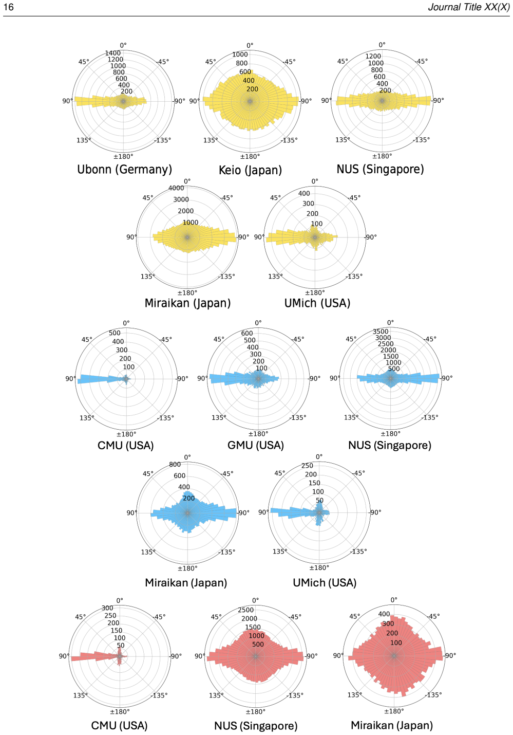
On its own terms, the paper's discovery is that a coordinated multi-site collection effort can produce a social-navigation dataset with broader cultural and morphological coverage than prior efforts, and that this breadth changes what models see. ACME robot trajectories are shorter and more goal-directed than earlier in-the-wild datasets; scenes are more socially constrained, with pedestrians closer to the robot; and off-the-shelf planners fail more often per meter. Pedestrian tracks show large variance in speed, density, and duration, and measurable cross-country differences in passing side and personal space (right-side passing in US and German data, left-side tendencies in Singapore and J
What carries the argument
The central object is the dataset itself: synchronized multi-modal onboard recordings (odometry, egocentric RGB, 3D LiDAR, and timestamped robot speech in some subsets) plus overhead bird's-eye-view (BEV) cameras whose pedestrian tracks are converted from pixel coordinates to ground-plane metric coordinates via homography matrices. That conversion is the load-bearing mechanism for the cross-cultural trajectory analysis, turning overhead video into quantitative distances, speeds, and passing-side measurements. A second mechanism is the annotation pipeline: automated tracking followed by human verification at 10 Hz, with tools to relabel, add, break, join, and disentangle tracks, which support
Load-bearing premise
The paper's own section on transforming BEV images to ground plane acknowledges 'the inherent inaccuracies of tag-based homography estimation'; that calibration accuracy, turning overhead camera pixels into ground-plane meters, is the load-bearing premise for the metric-space trajectory statistics and cross-cultural comparisons.
What would settle it
Place surveyed ground-truth markers at each collection site, project them through the published homographies, and compare to their measured positions; if typical errors exceed roughly half a meter, the metric-space trajectory statistics and cross-cultural comparisons would not be trustworthy.
If this is right
- Trajectory-prediction models trained on long-standing benchmarks lose about 0.1 m ADE and 0.15 m FDE when evaluated on ACME, and more when only moving pedestrians are considered, making ACME a harder generalization benchmark.
- Off-the-shelf geometric planners fail two to four times more often per minute or per meter on ACME than on earlier social-navigation datasets, making ACME useful for stress-testing planners in socially constrained scenes.
- The dataset's scenario tags (narrow corridors, blind corners, crowds, queues, overtaking) let researchers filter for specific situations, so policies can be trained or evaluated on the long tail of social navigation rather than on averaged behavior.
- Robot speech annotations tied to pedestrian density and traversability provide a first real-world resource for learning when a robot should speak to negotiate space, not just how it should move.
- Because trajectories are grounded in metric coordinates and verified by humans, the dataset can support quantitative study of how walking speed, passing side, and personal space vary by country and environment layout.
Where Pith is reading between the lines
- A direct test the paper does not run: if ACME delivers the diversity it claims, a navigation policy trained on a subset of its countries should transfer to a held-out country better than a policy trained on a single country; that experiment would separate the value of data volume from the value of cultural coverage.
- The passing-side results imply that 'socially compliant' navigation has no single ground truth; deployed robots may need to infer or adapt to local conventions, which points toward learning algorithms that condition on geography or context rather than a universal policy.
- The heavy presence of static and slow pedestrians in ACME suggests that trajectory predictors should model intent (standing, conversing, queueing) explicitly; the paper's dynamic-only benchmark hints at this, but the dataset's semantic tags make a stronger intent-aware training setup possible than the paper explores.
Editorial analysis
A structured set of objections, weighed in public.
Referee Report
Summary. The paper introduces ACME, a social-navigation and pedestrian-trajectory dataset collected by 8 teams at 8 sites in 5 countries using 7 robot embodiments. It comprises 29.35 hours of onboard robot data (odometry, RGB, LiDAR, and, for some subsets, robot speech) and 43.5 hours of overhead BEV pedestrian data, with 72.1K human-verified pedestrian trajectories provided in pixel and metric coordinates. The authors compare ACME with SCAND and MuSoHu on pedestrian density, traversability, and planner failure rates; benchmark vision-navigation models (ViNT, NoMAD) and trajectory-prediction models (SocialGAN, AgentFormer, SGNet, TUTR, MoFlow); and use the BEV data to analyze cross-cultural differences in walking speed, passing side, and personal space. The headline claims are that ACME is the largest and most diverse human-demonstrated social-navigation and trajectory-prediction dataset and that it captures more challenging scenarios and a broader distribution of pedestrian behavior than prior datasets.
Significance. If the claims hold, ACME would be a substantial community resource. Its strengths include multi-country and multi-embodiment coverage, a large human-verified BEV trajectory set with metric coordinates, scenario and semantic tags, robot-speech annotations, and a reproducible-style pipeline with open-sourced annotation tools and processing scripts. The paper also provides initial benchmarks for both navigation and trajectory-prediction models, which can serve as baselines for future work. The multi-site IRB/ethics documentation is a positive example for dataset papers. The main risk is that the quantitative value of the dataset depends on unvalidated homography and synchronization procedures, and the 'more challenging' claim relies on proxy metrics whose definitions are not fully specified. These issues are fixable and should be addressed before publication.
major comments (4)
- [Transformation from BEV Image Plane to Ground Plane] Metric-space trajectories are a central contribution, and they feed the cross-cultural analyses (Figs. 17-18) and the trajectory-prediction benchmark (Table 6). However, the paper provides no quantitative validation of the BEV-to-ground homographies. The text acknowledges 'the inherent inaccuracies of tag-based homography estimation' and later limits trajectories to within ±25 m of the poster tag, but no reprojection-error statistics, ground-truth comparisons, or distance-dependent sensitivity analyses are reported. In addition, the Miraikan/Keio synchronization uses manual frame selection (Appendix), whose temporal error is not quantified. Please report per-site reprojection RMSE and validate on surveyed points, and show that coordinate errors are small relative to the reported effects: ADE/FDE gaps of 0.1-0.38 m in Table 6 and personal-space differences of roughly 0.5-1 m in Fig. 18. W
- [Comparison to a Geometric Planner (Fig. 13)] The claim that ACME is 'more challenging' than SCAND and MuSoHu relies heavily on the TEB planner failure rates shown in Fig. 13. However, the manuscript never defines what counts as a planner failure, reports raw failure counts, or provides confidence intervals. The statement that 'the primary mode of planner failure is the presence of pedestrians at the sampled goal position' is asserted but not substantiated with quantitative evidence. Because the comparison across datasets depends on local planner parameters, costmap configuration, and the failure criterion, these details are load-bearing. Please state the failure definition (e.g., no plan within timeout, oscillation, collision), report counts and rates per dataset, and include a sensitivity analysis with respect to planner settings.
- [Traversability analysis (Fig. 10)] The traversability metric is computed with 'a finetuned SAM2 model,' but the manuscript does not describe how that model was trained, what data it was trained on, how the traversability mask is defined, or how accurate its predictions are on the egocentric images of SCAND, MuSoHu, and ACME. The cited reference (Wang et al. 2024b) appears to be a navigation system rather than the segmentation model used. Since this proxy feeds Fig. 10(d)-(g) and the robot-speech analysis in Fig. 12, please document the model and validate its outputs on a manually annotated sample from each dataset, or otherwise present the traversability results as illustrative rather than as a basis for the 'more challenging' claim.
- [Comparison across Datasets (Figs. 17-18)] The passing-side and personal-space analyses are presented as evidence that ACME captures cross-cultural behavioral differences, but no confidence intervals, sample sizes per direction bin, or statistical tests are reported. The observed left/right preferences and personal-space differences could be influenced by per-site homography errors, within-tag variation in corridor widths, or small interaction counts in some direction bins. The paper already hedges that 'lateral differences should not be attributed too strongly to culture,' but the figures and surrounding text nevertheless draw directional conclusions. Please provide uncertainty quantification and, where appropriate, statistical tests, or explicitly frame these results as descriptive observations.
minor comments (4)
- [Data Accessibility Statement] The data accessibility statement says the dataset is shared 'via a password-protected Box in the following link:' but the link appears to be empty in the manuscript. Please include the URL, or at minimum a clear description of how reviewers can access the data.
- [Traversability section] The term 'finetuned SAM2' is ambiguous. Please clarify whether this refers to the SAM2 segmentation model or to a traversability model from the cited Wang et al. (2024b) work, and add the appropriate citation.
- [Fig. 15 and Table 5] The standard-deviation values are reported as '±' numbers without being defined in the caption or text. Please state explicitly that these are standard deviations, and consider adding the number of trajectories per sub-dataset in Fig. 15.
- [Abstract] The abstract refers to 'A Cross-cultural' dataset while the title uses 'Multi-Cultural.' Please standardize the terminology across the paper.
Circularity Check
No significant circularity; central dataset claims rest on independent collection, statistics, and external benchmarks.
full rationale
The paper's central claims are that ACME is the largest/diverse social-navigation and trajectory-prediction dataset and that it captures more challenging scenarios and a broader distribution of pedestrian behavior. These claims are supported by independent evidence: duration/trajectory counts in Table 5; scenario-complexity metrics computed with external off-the-shelf detectors (ByteTrack, SAM2) and the TEB planner applied uniformly to ACME, SCAND, and MuSoHu; trajectory-prediction benchmarks using models trained on ETH/UCY and evaluated on ACME; and behavioral statistics derived from the annotated metric trajectories. No fitted parameter is renamed as a prediction, and no equation reduces a claimed result to its own input by construction. The acknowledged homography inaccuracy ('we acknowledge the inherent inaccuracies of tag-based homography estimation') is a measurement-error/validity concern, not circularity: the homographies come from AprilTags or surveyed keypoints, not from the pedestrian trajectories they transform. Similarly, QR-code or manual-frame temporal synchronization is a data-quality limitation, not a circular step. Self-citations with overlapping authors exist (e.g., TBD, Bi3, Raj et al., Mavrogiannis et al. 2023), but they are used for methodology inspiration, prior-work context, or as comparison baselines; none is load-bearing for the size, diversity, or challenge claims. The 'more challenging' conclusion from planner failure rates is an external, in-principle falsifiable measurement. The paper also explicitly cautions that FPV-space quantities 'should not be interpreted as direct metric measurements,' showing awareness of limits. Overall, the derivation chain is self-contained relative to the paper's fitted values, and the central claims have independent content; only minor non-load-bearing self-citation keeps the score above zero.
Axiom & Free-Parameter Ledger
free parameters (7)
- Interaction distance threshold =
4 m
- Dynamic pedestrian speed threshold =
0.5 m/s
- Minimum trajectory duration =
3.2 s
- Trajectory smoothing window =
5
- Jump fix velocity threshold =
5 m/s
- Ground-plane bounding box =
±25 m
- BEV sampling rate for predictions =
2.5 Hz
axioms (5)
- domain assumption Homography estimation via AprilTags/keypoints yields accurate ground-plane projection
- domain assumption SAM2 traversability and YOLO/ByteTrack pedestrian detection are reliable proxies for scene complexity
- domain assumption TEB planner failures measure scenario challenge
- domain assumption Human verification of ByteTrack trajectories yields ground-truth pedestrian positions
- domain assumption Cultural inferences are justified by five countries and site selection
read the original abstract
Understanding how robots and humans move in shared spaces is essential for designing effective social robot navigation policies and predicting human behavior. However, existing datasets often lack the diversity needed to capture differences in culture, geography, and human-robot interaction-factors that strongly shape appropriate social behavior. To address this gap, we introduce ACME: A Cross-cultural, Multi-Embodiment dataset for social navigation. A large-scale data collection effort across 8 sites in 5 countries, using 7 robot embodiments, ACME is a large and diverse multi-modal dataset aimed at advancing social navigation research, providing 29.35 hours of onboard robot data and 43.5 hours of overhead pedestrian tracking data. Unlike prior datasets, it focuses on capturing goal-driven social navigation behavior in complex social scenarios with explicit robot-crowd interaction through robot speech. To facilitate learning navigation policies and predicting pedestrian trajectories, ACME provides 3D and 2D scene features, odometry, interaction information, and human-annotated pedestrian trajectory labels. We make ACME easy to use by providing both human-readable data for each sensor modality as well as raw binary data. Our qualitative and quantitative analyses show that our dataset captures more challenging scenarios and a broader distribution of pedestrian behavior than previous datasets.
Figures




Reference graph
Works this paper leans on
-
[1]
Agrawal S, Ostermann-Myrau N, Dengler N and Bennewitz M (2026) Peroi: A pedestrian-robot interaction dataset for learning avoidance, neutrality, and attraction behaviors in social navigation. In:Proc. of IEEE International Conference on Robotics and Automation (ICRA). Alahi A, Goel K, Ramanathan V , Robicquet A, Fei-Fei L and Savarese S (2016a) Social lst...
2026
-
[7]
IEEE, pp. 3153–3160. Olson E (2011) Apriltag: A robust and flexible visual fiducial system. In:2011 IEEE international conference on robotics and automation. IEEE, pp. 3400–3407. Paez-Granados D, He Y , Gonon D, Jia D, Leibe B, Suzuki K and Billard A (2022a) Pedestrian-robot interactions on autonomous crowd navigation: Reactive control methods and evaluat...
arXiv 2011
-
[38]
pp. 474–482. Chen YF, Liu M, Everett M and How JP (2017) Decentralized non-communicating multiagent collision avoidance with deep reinforcement learning. In:2017 IEEE international conference on robotics and automation (ICRA). IEEE, pp. 285–
2017
-
[292]
Cheng AC, Ji Y , Yang Z, Gongye Z, Zou X, Kautz J, Bıyık E, Yin H, Liu S and Wang X (2024) Navila: Legged robot vision-language-action model for navigation.arXiv preprint arXiv:2412.04453. De Heuvel J, Corral N, Kreis B, Conradi J, Driemel A and Bennewitz M (2023) Learning depth vision-based personalized robot navigation from dynamic demonstrations in vir...
Pith/arXiv arXiv 2024
-
[803]
Trautman P, Ma J, Murray RM and Krause A (2015) Robot navigation in dense human crowds: Statistical models and experimental studies of human–robot cooperation.The International Journal of Robotics Research34(3): 335–356. Van Den Berg J, Snape J, Guy SJ and Manocha D (2011) Reciprocal collision avoidance with acceleration-velocity obstacles. In:2011 IEEE I...
arXiv 2015
-
[864]
ACM Transactions on Human-Robot Interaction14(2)
Francis A, P ´erez-D’Arpino C, Li C, Xia F, Alahi A, Alami R, Bera A, Biswas A, Biswas J, Chandra R, Chiang HTL, Everett M, Ha S, Hart J, How JP, Karnan H, Lee TWE, Manso LJ, Mirsky R, Pirk S, Singamaneni PT, Stone P, Taylor A V , Trautman P, Tsoi N, V ´azquez M, Xiao X, Xu P, Yokoyama N, Toshev A and Mart ´ın-Mart´ın R (2025) Principles and guidelines fo...
arXiv 2025
-
[1572]
Sorokowska A, Sorokowski P, Hilpert P, Cantarero K, Frackowiak T, Ahmadi K, Alghraibeh AM, Aryeetey R, Bertoni A, Bettache K et al
Song D, Liang J, Payandeh A, Raj AH, Xiao X and Manocha D (2024) Vlm-social-nav: Socially aware robot navigation through scoring using vision-language models.IEEE Robotics and Automation Letters. Sorokowska A, Sorokowski P, Hilpert P, Cantarero K, Frackowiak T, Ahmadi K, Alghraibeh AM, Aryeetey R, Bertoni A, Bettache K et al. (2017) Preferred interpersona...
2024
-
[2011]
3457–3464
IEEE, pp. 3457–3464. Bradwell HL, Winnington R, Thill S and Jones RB (2021) Morphology of socially assistive robots for health and social care: A reflection on 24 months of research with anthropomorphic, zoomorphic and mechanomorphic devices. In:2021 30th IEEE International Conference on Robot & Human Interactive Communication (RO-MAN). IEEE, pp. 376–383....
2021
-
[2016]
ISBN 978-3-319-46484-8, pp. 549–565. R¨osmann C, Hoffmann F and Bertram T (2017) Integrated online trajectory planning and optimization in distinctive topologies. Robotics and Autonomous Systems88: 142–153. Rudenko A, Kucner TP, Swaminathan CS, Chadalavada RT, Arras KO and Lilienthal AJ (2020a) Th ¨or: Human-robot navigation data collection and accurate m...
Pith/arXiv arXiv 2017
-
[2022]
ISBN 978- 3-031-20047-2, pp
Cham: Springer Nature Switzerland. ISBN 978- 3-031-20047-2, pp. 1–21. Zhou B, Wang X and Tang X (2012) Understanding collective crowd behaviors: Learning a mixture model of dynamic pedestrian-agents. In:2012 IEEE Conf. on Comput. Vis. and Pattern Recognit.IEEE, pp. 2871–2878. Zhu Y , Yang SM, Magnusson M and Wang A (2026) Hicrowd: Hierarchical crowd flow ...
2012
-
[2026]
18699 67.2 2D trajectory from bird’s eye camera Teleop 3 Outdoor Bi3 (Stratton et al. 2026a) 185 630 Motion Capture System, RGB Camera, Depth Camera Autonomous 2 Indoor ACME 3013 1761 3D-LiDAR, RGB(D) Camera, Overhead BEV Cameras, Odometry Human operated, Teleop 7 Both Prepared usingsagej.cls 24 Journal Title XX(X) Appendix Miscellaneous Details Data Cura...
2021
-
[4282]
In:2018 IEEE/RSJ international conference on intelligent robots and systems (IROS)
Hirose N, Sadeghian A, V ´azquez M, Goebel P and Savarese S (2018) Gonet: A semi-supervised deep learning approach for traversability estimation. In:2018 IEEE/RSJ international conference on intelligent robots and systems (IROS). IEEE, pp. 3044–3051. Hirose N, Shah D, Sridhar A and Levine S (2023) Sacson: Scalable autonomous control for social navigation....
arXiv 2018
discussion (0)
Sign in with ORCID, Apple, or X to comment. Anyone can read and Pith papers without signing in.