REVIEW 5 major objections 5 minor 53 references
MOSAIC claims that expressing every mission objective as a shared Point of Interest, managed centrally while robots execute them locally with layered autonomy, lets a single operator supervise a heterogeneous five-robot science team that ke
Reviewed by Pith at T0; open to challenge. T0 means a machine referee read the full paper against a public rubric. the ladder, T0–T4 →
T0 review · deepseek-v4-flash
2026-08-03 06:14 UTC pith:43CSZOO6
load-bearing objection A solid field-robotics engineering report whose abstract oversells the failure-robustness evidence: the robot that 'failed' was already out of the mission. the 5 major comments →
MOSAIC: Modular Scalable Autonomy for Intelligent Coordination of Heterogeneous Robotic Teams
The pith
A machine-rendered reading of the paper's core claim, the machinery that carries it, and where it could break.
Core claim
MOSAIC's central discovery is that a unified mission abstraction (POIs) combined with layered autonomy lets a small team of heterogeneous robots run a scientific exploration mission under one operator, and that the design absorbs individual robot failures without mission abort. The system keeps a global mission state on a mission-control station, while every robot runs its own POI planner and behavior tree that ranks and claims objectives by utility (POI type, distance, navigation cost, battery). Because roles such as scout and scientist are each covered by multiple robots, a failed robot's objectives are naturally reallocated to its teammates. The field evaluation backs this up: despite the
What carries the argument
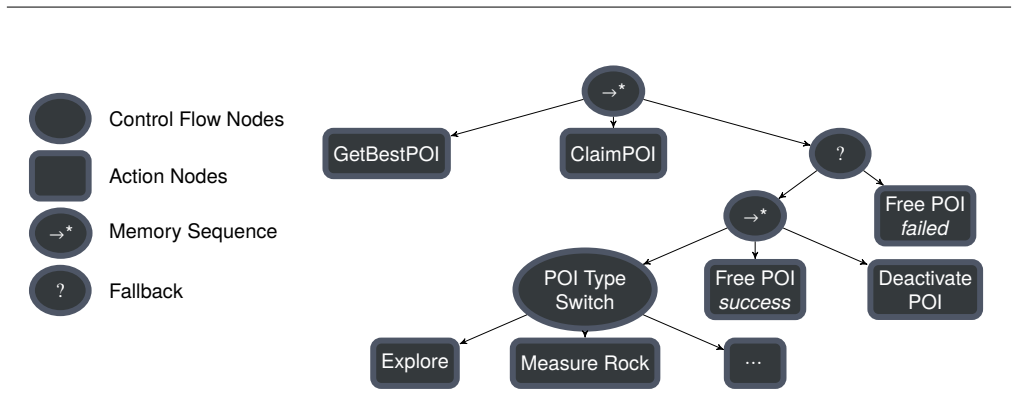
The central object is the Point of Interest (POI) — a location in a shared earth frame, tagged with a type and metadata — which serves as the single mission-level unit of progress. Around it, the framework's key machinery is the three-layer autonomy stack (mission level: central POI management and operator interface; robot level: local POI planner plus behavior-tree execution; driver level: direct teleoperation) and an iterative, multi-step greedy planner that computes per-robot utilities from weighted features (type suitability, Euclidean and navigation distance, battery use), broadcasts planned utilities to teammates to avoid conflicts, and prunes distant candidates early. Role definition
Load-bearing premise
The framework assumes that one initial alignment of the robots' maps keeps them in a common coordinate frame for the entire mission; without continuous co-localization, drift will eventually make a POI mean different physical locations for different robots.
What would settle it
Run the system on a site larger than 60x40 m or for longer than 40 minutes without re-localizing robots, then compare a known landmark's coordinates in each robot's map: if the inter-robot error grows beyond the reach or sensor coverage of the assigned robot, the shared-POI abstraction, and with it the scalability claim, fails. The paper's own map-error measurement (0.145 m ± 0.252 m) gives a starting baseline to extrapolate from.
If this is right
- With this framework, a single operator can run a five-robot exploration and measurement mission, with robots spending most of the mission in full autonomy and the operator intervening mainly for mission-level decisions.
- The POI abstraction means a robot failure does not stop the mission: tasks are reallocated among remaining robots, as happened when the scout with automatic rock detection was lost.
- The architecture's separation of mission-level objectives from robot-specific execution makes it possible to add or swap robot types without changing the mission representation.
- Network design choices (best-effort topics, domain separation, throttled transforms) reduce wireless bandwidth to about 20 Mbit/s for a five-robot team over one Wi-Fi access point.
- The reported KPIs (82.3% task success, 86% autonomy ratio) define a baseline for evaluating future multi-robot exploration systems and isolate operator workload as a key scaling bottleneck.
Where Pith is reading between the lines
- The scalability in the title is bounded by the 40-minute, 60x40 m validation: the shared-world consistency rests on a one-time ICP alignment, so longer missions or larger areas would need continuous cooperative localization before the same architecture can be claimed to scale.
- Because resource identification (56.2%) is far below task completion (82.3%), the framework's autonomy is strongest at executing objectives, not at deciding what is scientifically interesting; a testable improvement would be to automate more of the target-detection and measurement-point refinement that now relies on the scientist-in-the-loop.
- The operator workload of 78.2% is close to saturation, so scaling to ten robots would likely require the automated operator task queue and a dedicated teleoperator that the authors propose as future work; a worthwhile experiment is to measure how workload scales as team size grows under the same layered-autonomy design.
- The reported lessons — e.g., favoring homogeneous software stacks, avoiding mixed-version middleware bridges, and maintaining scout-to-scientist ratio — can be read as a prescriptive recipe for future planetary missions, and each could be turned into a controlled comparison study.
Editorial analysis
A structured set of objections, weighed in public.
Referee Report
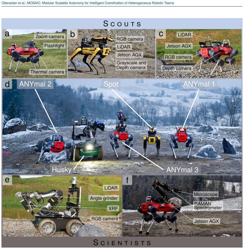
Summary. The paper presents MOSAIC, a framework for supervised autonomy of heterogeneous multi-robot teams built around a mission-level Points-of-Interest abstraction, multiple autonomy levels (mission, task, driver), and a mixed ROS 1/ROS 2 communication architecture. The system was field-tested in a lunar-analog scenario with five robots — three scouts and two scientists — over a 40-minute mission. The authors report 82.3% task success, 86% Autonomy Ratio, 78.2% operator workload, and argue that the team remained effective despite the complete loss of one robot. The paper also contributes practical lessons on interoperability, networking, team composition, and operator workload.
Significance. If the headline claims were fully supported, MOSAIC would be a useful contribution to heterogeneous multi-robot field autonomy, particularly in space-analog settings. The strengths of the paper are genuine: a real field deployment with heterogeneous legged and wheeled platforms, directly reported trajectories and maps, concrete measurement examples, and an unusually candid discussion of the engineering difficulties encountered (ROS 1/2 bridging, DDS QoS, drift, operator workload). The feasibility of the integrated system is demonstrated. However, the evidence base is a single 40-minute run with no baseline or repetitions, and several KPI definitions are post-hoc or self-referential. The central robustness claim — that the framework absorbs the complete mid-mission failure of a robot — is not supported by the reported data, and the scalability claim is acknowledged by the authors to require co-localization work that is not yet implemented.
major comments (5)
- [Abstract, §VI.A, §VIII] The abstract and conclusion claim that the team continued despite 'the complete failure of one robot during the mission.' Section VI.A states that Dodo suffered water damage and was taken out of operation during the first two days, before the final campaign; the reported results refer to the final campaign using 'all functioning robots.' Figure 8 shows trajectories and activities for Spot, Dilly, Donkey, and Husky only, and Spot's software/networking issue at the start prevented its behavior tree but did not cause a complete loss — Spot was used as a teleoperated camera platform. Thus the key robustness demonstration is not present in the reported run. Either report a mission with a genuine mid-mission total failure or revise the claims to describe the actual scenario (a robot lost before the final run).
- [§VI.C, Table 1] The 'Task Success Ratio' of 82.3% is the success rate of scientific measurements performed by Donkey and Husky only (14 of 17 attempts: Donkey 5/5 ground and 3/5 rock; Husky 6/7 ground). It is not a team-level or mission-level success metric covering exploration, mapping, and POI handling. The abstract's phrase 'completed 82.3% of assigned tasks' overstates what was measured. With only 17 attempts, no confidence interval is reported. Please report per-robot and per-POI-type counts with uncertainty, and use a mission-level definition if that is the intended claim.
- [§VI.A, Table 1] The Robot Downtime and Autonomy Ratio results rely on excluding Husky's 80.8% apparent planning time as 'incorrect state labeling' rather than actual inactivity. This post-hoc exclusion changes total Robot Downtime from 52% to 37.8%, a large swing in a headline KPI. The paper does not provide independent evidence — e.g., log excerpts showing that Husky was executing POIs while its behavior tree failed to record them. If the state labeling is unreliable, then the logged state data underlying this KPI is itself questionable. Please justify the exclusion with concrete log evidence or report both values without asserting which is correct.
- [§IV.D, §VII] The shared mission abstraction depends on a consistent earth frame across robots, but co-localization is performed only once at startup via ICP alignment; Section IV.D states that no continuous co-localization is performed, and Section VII acknowledges that a reliable co-localization strategy is needed for longer deployments. The reported 60 m × 40 m, 40-minute experiment therefore cannot validate the 'scalable' claim, which is central to the paper's title and motivation. Please either add a quantitative drift analysis over the mission and a clear statement of the operational envelope, or explicitly restrict the scalability claim to future work.
- [§VI, Table 1] All headline numbers — Task Success Ratio, Autonomy Ratio, Quantitative Operator Workload, mapping rates, and Map Error — are single-run point estimates from one 40.3-minute mission with no baseline comparison, no repetitions, and no confidence intervals (except the Map Error standard deviation). For a validation claim about robustness and scalability, this is insufficient. The authors should at least state explicitly that this is a single case study, and ideally include repeated runs or, if that is not feasible, frame the results as a feasibility demonstration rather than a performance validation.
minor comments (5)
- [Eq. (1)] The formula for the depth-weighted utility is ambiguous as typeset: 'utility × duf^current_depth' appears as 'utility × duf current_depth'. Please clarify whether the depth_uncertainty_factor is raised to the current depth or multiplied by it, and define how the weights in the utility features are configured.
- [§VI.C] The text refers to 'Husky’s RFA scan,' but the instrument described in §IV.B.2 is an XRF (Olympus Vanta). Please correct the acronym.
- [Table 1 / §VI.B] The 'Ratio of Identified Resources' (56.2%) is derived from human identification because Dodo, the autonomous rock-detection robot, was unavailable; Section VI.C states that 'the ratio of autonomously identified rocks could not be determined.' This distinction should be made explicit in the table or its caption so the KPI is not misread as an autonomy metric.
- [Figure 8] The captions for panels (a) and (b) appear to be duplicated in the typeset manuscript. Please correct the caption for panel (b) to match the operator timeline it displays.
- [§IV.C.3] The POI planning depends on several operator-defined weights (type reward, distance, battery, and the depth_uncertainty_factor). No sensitivity analysis is provided, and the paper does not state how these weights were chosen. A brief discussion of sensitivity or a reference to the companion configuration would help readers judge the generality of the allocation behavior.
Circularity Check
No circular derivation; field-data evaluation has independent content, though the robustness example is not clearly supported and co-localization is acknowledged as open.
full rationale
The paper's only formal rule is Eq. (1), utility_weighted = utility × duf_current_depth, which discounts utility by planning depth; no reported output is defined from itself. The headline quantities (82.3% Task Success Ratio, 86% Autonomy Ratio, 78.2% Quantitative Operator Workload) are post-hoc counts from logged mission data (e.g., Donkey 14 attempts with 12 successful, Husky 9 attempts with 7 successful; RAD = IE/(IE+NT)), so they are measured outcomes, not forced predictions. The evaluation does use the authors' KPI framework [15] and the architecture builds on [13], but neither citation defines the outcome: the team could plausibly have scored worse. The genuine weaknesses are evidence issues rather than circularity. Section VI.A reports that Dodo "suffered water damage and had to be taken out of operation" during the first two days, before the final campaign, whereas the abstract's "complete failure of one robot during the mission" suggests a mid-mission failure in the reported run. Section IV.D states "After the initial alignment of the robot maps, no continuous co-localization is performed," and Section VII concedes "a reliable co-localization strategy is needed" for longer deployments; these limit scalability support but are not self-referential derivations. Score 2 reflects two non-load-bearing self-references (KPI definitions and base architecture), not equivalence-to-input or prediction-by-construction.
Axiom & Free-Parameter Ledger
free parameters (5)
- POI utility feature weights
- depth_uncertainty_factor (duf) =
≤1.0, value not stated
- planning depth =
not stated
- POI type rewards
- Husky motion penalty adjustment =
high penalties, values not stated
axioms (5)
- domain assumption No continuous co-localization; the initial ICP alignment of local maps remains valid for the mission duration.
- domain assumption Single-access-point Wi-Fi with the QoS design supports the mission communication requirements.
- domain assumption The KPI metrics from [15] quantify operator workload and autonomy as intended.
- ad hoc to paper Husky's high apparent planning time (80.8%) was an incorrect state-labeling bug, not real inactivity.
- domain assumption Human-in-the-loop validation and operator-created POIs are part of the system, not external assistance.
invented entities (1)
-
Mission-level POI abstraction
no independent evidence
read the original abstract
Mobile robots have become indispensable for exploring hostile environments, such as in space or disaster relief scenarios, but often remain limited to teleoperation by a human operator. This restricts the deployment scale and requires near-continuous low-latency communication between the operator and the robot. We present MOSAIC: a scalable autonomy framework for multi-robot scientific exploration using a unified mission abstraction based on Points of Interest (POIs) and multiple layers of autonomy, enabling supervision by a single operator. The framework dynamically allocates exploration and measurement tasks based on each robot's capabilities, leveraging team-level redundancy and specialization to enable continuous operation. We validated the framework in a space-analog field experiment emulating a lunar prospecting scenario, involving a heterogeneous team of five robots and a single operator. Despite the complete failure of one robot during the mission, the team completed 82.3% of assigned tasks at an Autonomy Ratio of 86%, while the operator workload remained at only 78.2%. These results demonstrate that the proposed framework enables robust, scalable multi-robot scientific exploration with limited operator intervention. We further derive practical lessons learned in robot interoperability, networking architecture, team composition, and operator workload management to inform future multi-robot exploration missions.
Figures





Reference graph
Works this paper leans on
-
[1]
Seo, S. H., Young, J. E., and Irani, P., “How are your robot friends doing? a design exploration of graphical techniques supporting awareness of robot team members in teleoperation,”International Journal of Social Robotics, vol. 13, no. 4, pp. 725–749, Jul. 1, 2021, ISSN: 1875-4805. DOI:10.1007/s12369-020-00670-9
-
[2]
Still not solved: A call for renewed focus on user-centered teleoperation interfaces,
Rea, D. J. and Seo, S. H., “Still not solved: A call for renewed focus on user-centered teleoperation interfaces,”Frontiers in Robotics and AI, vol. 9, Mar. 29, 2022, ISSN: 2296-9144. DOI:10.3389/frobt.2022. 704225
-
[3]
Inspiring field robotics advances through the design of the DARPA subterranean challenge,
Orekhov, V. L., Maio, A. C., Daniel, R. P., and Chung, T. H., “Inspiring field robotics advances through the design of the DARPA subterranean challenge,” Field Robotics, vol. 3, pp. 560–604, Apr. 2023, ISSN: 2771-3989. DOI:10.55417/fr.2023018
-
[4]
Toward multi user knowledge driven teleop- eration of a robotic team with scalable autonomy,
Schmaus, P. et al., “Toward multi user knowledge driven teleop- eration of a robotic team with scalable autonomy,” in2023 IEEE International Conference on Systems, Man, and Cybernetics (SMC) , Oct. 2023, pp. 867–873. DOI:10.1109/SMC53992.2023.10394365
arXiv 2023
-
[5]
Curiosity: The mars science laboratory project,
Cook, R. A., “Curiosity: The mars science laboratory project,” pre- sented at the International Astronautical Federation, Paris, France, Oct. 1, 2012
2012
-
[6]
Overview and results from the mars 2020 perseverance rover’s first science campaign on the jezero crater floor,
Sun, V. Z. et al., “Overview and results from the mars 2020 perseverance rover’s first science campaign on the jezero crater floor,” Journal of Geophysical Research: Planets , vol. 128, no. 6, e2022JE007613, 2023, ISSN: 2169-9100. DOI: 10.1029/ 2022JE007613
2020
-
[7]
Prorok, A., Malencia, M., Carlone, L., Sukhatme, G. S., Sadler, B. M., and Kumar, V., Beyond robustness: A taxonomy of ap- proaches towards resilient multi-robot systems , Sep. 25, 2021. DOI: 10.48550/arXiv.2109.12343
-
[8]
[Online]
NASA / JPL, Mars rover mission comes to an end but science legacy lives on. [Online]. Available:https://www.jpl.nasa.gov/edu/ resources/teachable-moment/mars-rover-mission-comes-to-an- end-but-science-legacy-live-on/
-
[9]
The challenge 2021-2022,
European Space Agency and European Space Resources Innovation Centre. “The challenge 2021-2022,” SPACE RESOURCES CHAL- LENGE, Accessed: Sep. 10, 2025. [Online]. Available:https://src. esa.int/the-challenge-2021-2022/
2021
-
[10]
Cerberus in the darpa subterranean challenge,
Tranzatto, M. et al., “Cerberus in the darpa subterranean challenge,” Science Robotics, vol. 7, no. 66, eabp9742, 2022. DOI:10.1126/ scirobotics.abp9742
2022
-
[11]
Kottege, N. et al., “Heterogeneous robot teams with unified per- ception and autonomy: How team CSIRO data61 tied for the top score at the DARPA subterranean challenge,”IEEE Transactions on Field Robotics, vol. 2, pp. 100–130, 2025, ISSN: 2997-1101. DOI: 10.1109/TFR.2024.3522063
arXiv 2025
-
[12]
Scientific exploration of challenging planetary ana- log environments with a team of legged robots,
Arm, P. et al., “Scientific exploration of challenging planetary ana- log environments with a team of legged robots,”Science Robotics, vol. 8, no. 80, eade9548, Jul. 12, 2023. DOI:10.1126/scirobotics. ade9548 23 Oberacker et al. : MOSAIC: Modular Scalable Autonomy for Intelligent Coordination of Heterogeneous Robotic Teams
-
[14]
REALMS: Resilient exploration and lunar mapping system,
Meer, D. van der et al., “REALMS: Resilient exploration and lunar mapping system,” Frontiers in Robotics and AI , vol. 10, Mar. 30, 2023, ISSN: 2296-9144. DOI:10.3389/frobt.2023.1127496
arXiv 2023
-
[15]
A Practical Framework of Key Performance Indicators for Multi-Robot Lunar and Planetary Field Tests
Richter, J. et al.,A practical framework of key performance indi- cators for multi-robot lunar and planetary field tests , 2026. DOI: 10.48550/ARXIV.2601.20529
work page internal anchor Pith review Pith/arXiv arXiv doi:10.48550/arxiv.2601.20529 2026
-
[16]
Flexible supervised autonomy for exploration in subterranean environments,
Biggie, H. et al., “Flexible supervised autonomy for exploration in subterranean environments,” Field Robotics, vol. 3, pp. 125–189,
-
[17]
Autonomous exploration development environment and the planning algorithms,
Cao, C. et al., “Autonomous exploration development environment and the planning algorithms,” in2022 International Conference on Robotics and Automation (ICRA), IEEE, 2022, pp. 8921–8928. DOI: 10.1109/ICRA46639.2022.9812330
arXiv 2022
-
[18]
Cooperative robotic exploration of a plan- etary skylight surface and lava cave,
Domínguez, R. et al., “Cooperative robotic exploration of a plan- etary skylight surface and lava cave,”Science Robotics, vol. 10, no. 105, eadj9699, Aug. 13, 2025. DOI:10.1126/scirobotics.adj9699
-
[19]
LUNARES: Lunar crater exploration with hetero- geneous multi robot systems,
Cordes, F. et al., “LUNARES: Lunar crater exploration with hetero- geneous multi robot systems,”Intelligent Service Robotics , vol. 4, no. 1, pp. 61–89, 2011. DOI:10.1007/s11370-010-0081-4
-
[20]
A mission architecture for a human-robot collaborative planetary exploration cascade,
Jusner, S., Moser, S., Schaffler-Glößl, S., Halatschek, R., Eder, M., and Steinbauer-Wagner, G., “A mission architecture for a human-robot collaborative planetary exploration cascade,” in2024 International Conference on Space Robotics (iSpaRo) , IEEE, 2024, pp. 321–327. DOI:10.1109/iSpaRo60631.2024.10687418
arXiv 2024
-
[21]
The ARCHES space-analogue demonstration mission: Towards heterogeneous teams of autonomous robots for collaborative scientific sampling in planetary exploration,
Schuster, M. J. et al., “The ARCHES space-analogue demonstration mission: Towards heterogeneous teams of autonomous robots for collaborative scientific sampling in planetary exploration,” IEEE Robotics and Automation Letters , vol. 5, no. 4, pp. 5315–5322,
-
[22]
Fieldtestingofacooperativemulti-robotsample return mission in mars analogue environment,
Sonsalla,R.etal.,“Fieldtestingofacooperativemulti-robotsample return mission in mars analogue environment,” inProceedings of the 14th symposium on advanced space technologies in robotics and automation (ASTRA), 2017
2017
-
[23]
Hudson, N. et al., “Heterogeneous ground and air platforms, homo- geneous sensing: Team CSIRO data61’s approach to the DARPA subterranean challenge,”Field Robotics, vol. 2, pp. 595–636, 2022. DOI: 10.55417/fr.2022021
-
[24]
Crazyswarm: A large nano-quadcopter swarm,
Preiss, J. A., Honig, W., Sukhatme, G. S., and Ayanian, N., “Crazyswarm: A large nano-quadcopter swarm,” in 2017 IEEE International Conference on Robotics and Automation (ICRA) , May 2017, pp. 3299–3304. DOI:10.1109/ICRA.2017.7989376
arXiv 2017
-
[25]
Agha, A. et al., “Nebula: Quest for robotic autonomy in challenging environments; team costar at the darpa subterranean challenge,” arXiv preprint arXiv:2103.11470, 2021. DOI:10.48550/arXiv.2103. 11470
-
[26]
Robot operating system 2: Design, architecture, and uses in the wild,
Macenski,S.,Foote,T.,Gerkey,B.,Lalancette,C.,andWoodall,W., “Robot operating system 2: Design, architecture, and uses in the wild,” Science Robotics, vol. 7, no. 66, eabm6074, May 11, 2022. DOI: 10.1126/scirobotics.abm6074
-
[27]
ROS: An open-source robot operating system,
Morgan Quigley et al., “ROS: An open-source robot operating system,” in 2009 IEEE International Conference on Robotics and Automation (ICRA), Kobe, Japan: IEEE, 2009
2009
-
[28]
ANYmal – autonomous robotic inspection solu- tion
ANYbotics AG. “ANYmal – autonomous robotic inspection solu- tion. ”[Online]. Available:https://www.anybotics.com/robotics/ anymal/
-
[29]
Spot®, the agile mobile robot
Boston Dynamics, Inc. “Spot®, the agile mobile robot. ”[Online]. Available:https://bostondynamics.com/products/spot/
-
[30]
Learning robust perceptive locomotion for quadrupedal robots in the wild,
Miki, T., Lee, J., Hwangbo, J., Wellhausen, L., Koltun, V., and Hutter, M., “Learning robust perceptive locomotion for quadrupedal robots in the wild,” Science Robotics, vol. 7, no. 62, eabk2822, Jan. 19, 2022. DOI:10.1126/scirobotics.abk2822
-
[31]
Pedipulate: Enabling manipulation skills using a quadruped robot’s leg,
Arm, P., Mittal, M., Kolvenbach, H., and Hutter, M., “Pedipulate: Enabling manipulation skills using a quadruped robot’s leg,” in 2024 IEEE International Conference on Robotics and Automation (ICRA), May 2024, pp. 5717–5723. DOI:10.1109/ICRA57147.2024. 10611307
arXiv 2024
-
[32]
[Online]
Wu, Y., Kirillov, A., Massa, F., Lo, W.-Y., and Girshick, R., Detectron2, 2019. [Online]. Available: https : / / github . com / facebookresearch/detectron2
2019
-
[33]
Bdaiinstitute/spot_ros2, Nov. 3, 2025. Accessed: Nov. 4, 2025. [Online]. Available:https://github.com/bdaiinstitute/spot_ros2
2025
-
[34]
DynaArm – ultra-lightweight and weatherproof robotic arm
Duatic AG. “DynaArm – ultra-lightweight and weatherproof robotic arm. ”[Online]. Available:https://duatic.com/products/dynaarm/
-
[35]
et al., OCS2: An open source library for optimal control of switched systems , 2025
Farshidian, F. et al., OCS2: An open source library for optimal control of switched systems , 2025. [Online]. Available: https:// github.com/leggedrobotics/ocs2
2025
-
[36]
MIRA XTR,
“MIRA XTR,” Accessed: Jan. 19, 2026. [Online]. Available:https: //www.metrohm.com/de_de/produkte/raman-spektroskopie/mira- xtr.html
2026
-
[37]
VantaHandheld XRF Analyzer,
“VantaHandheld XRF Analyzer,” Accessed: Nov. 4, 2025. [Online]. Available: https://main--eds-evident-website--evident-scientific. aem.live/de/products/xrf-analyzers/vanta
2025
-
[38]
Distributed behavior trees for heterogeneous robot teams,
Heppner, G., Berg, N., Oberacker, D., Spielbauer, N., Roennau, A., and Dillmann, R., “Distributed behavior trees for heterogeneous robot teams,” in 2023 IEEE 19th International Conference on Automation Science and Engineering (CASE) , Aug. 2023, pp. 1–
2023
-
[39]
Grosse Besselmann, M., Puck, L., Steffen, L., Roennau, A., and Dillmann, R., “VDB-mapping: A high resolution and real-time capable 3d mapping framework for versatile mobile robots,” in 2021 IEEE 17th International Conference on Automation Science and Engineering (CASE) , Aug. 2021, pp. 448–454. DOI:10.1109/ CASE49439.2021.9551430
arXiv 2021
-
[40]
31, 2025
Leggedrobotics/open3d_slam, Oct. 31, 2025. Accessed: Nov. 4,
2025
-
[41]
DOI:10.1109/CASE56687.2023.10260300
arXiv 2023
-
[42]
3d global path planning for walking robots on sparse volumetric maps,
Grosse Besselmann, M. et al., “3d global path planning for walking robots on sparse volumetric maps,” in2024 IEEE/RSJ International Conference on Intelligent Robots and Systems (IROS) , Oct. 2024, pp. 5430–5437. DOI:10.1109/IROS58592.2024.10802767 24
arXiv 2024
-
[43]
An efficient locally reactive controller for safe navigation in visual teach and repeat missions,
Mattamala, M., Chebrolu, N., and Fallon, M., “An efficient locally reactive controller for safe navigation in visual teach and repeat missions,” IEEE Robotics and Automation Letters , vol. 7, no. 2, pp. 2353–2360, Apr. 2022, ISSN: 2377-3766. DOI:10.1109/LRA. 2022.3143196
arXiv 2022
-
[44]
19, 2025
Ori-drs/field_local_planner, Dec. 19, 2025. Accessed: Jan. 19,
2025
-
[45]
Real-time loop clo- sure in 2d LIDAR SLAM,
Hess, W., Kohler, D., Rapp, H., and Andor, D., “Real-time loop clo- sure in 2d LIDAR SLAM,” in2016 IEEE International Conference on Robotics and Automation (ICRA) , May 2016, pp. 1271–1278. DOI: 10.1109/ICRA.2016.7487258
arXiv 2016
-
[46]
MEM: Multi-modal elevation mapping for robotics and learning,
Erni, G., Frey, J., Miki, T., Mattamala, M., and Hutter, M., “MEM: Multi-modal elevation mapping for robotics and learning,” in 2023 IEEE/RSJ International Conference on Intelligent Robots and Systems (IROS) , Oct. 2023, pp. 11011–11018. DOI:10.1109/ IROS55552.2023.10342108
arXiv 2023
-
[47]
Leggedrobotics/elevation_mapping_cupy, Nov. 4, 2025. Accessed: Nov. 4, 2025. [Online]. Available: https : / / github . com / leggedrobotics/elevation_mapping_cupy
2025
-
[48]
NavPi: An adaptive local path-planning pipeline for 3d navigation in difficult terrain,
Grosse Besselmann, M., Rönnau, A., and Dillmann, R., “NavPi: An adaptive local path-planning pipeline for 3d navigation in difficult terrain,” in Synergetic Cooperation between Robots and Humans , E. S. E. Youssef, M. O. Tokhi, M. F. Silva, and L. M. Rincon, Eds., Cham: Springer Nature Switzerland, 2024, pp. 224–235, ISBN: 978- 3-031-47272-5. DOI:10.1007/9...
-
[49]
Exploringtheperformance of ROS2,
Maruyama,Y.,Kato,S.,andAzumi,T.,“Exploringtheperformance of ROS2,” in Proceedings of the 13th International Conference on Embedded Software , ser. EMSOFT ’16, New York, NY, USA: AssociationforComputingMachinery,Oct.1,2016,pp.1–10,ISBN: 978-1-4503-4485-2. DOI:10.1145/2968478.2968502 DAVID OBERACKERreceived the M.Sc. degree in informatics from the Karlsruhe...
arXiv 2016
-
[50]
Elevation mapping for locomotion and navigation using GPU,
Miki, T., Wellhausen, L., Grandia, R., Jenelten, F., Homberger, T., and Hutter, M., “Elevation mapping for locomotion and navigation using GPU,” in2022 IEEE/RSJ International Conference on Intel- ligent Robots and Systems (IROS) , Oct. 2022, pp. 2273–2280. DOI: 10.1109/IROS47612.2022.9981507
arXiv 2022
-
[2020]
DOI:10.1109/LRA.2020.3007468
arXiv 2020
-
[2023]
DOI:10.55417/fr.2023004
-
[2025]
Available: https://github.com/leggedrobotics/ open3d_slam
[Online]. Available: https://github.com/leggedrobotics/ open3d_slam
-
[2026]
Available:https://github.com/ori-drs/field_local_ planner
[Online]. Available:https://github.com/ori-drs/field_local_ planner
discussion (0)
Sign in with ORCID, Apple, or X to comment. Anyone can read and Pith papers without signing in.