REVIEW 3 major objections 4 minor 33 references
LiDAR Based Semantic Perception for Forklifts in Outdoor Environments
T0 review · 3 major / 4 minor · reviewed 2026-08-07 · deepseek-v4-flash
Pith's one-line read A dual-LiDAR semantic segmentation pipeline lets an autonomous counterbalance forklift classify its outdoor warehouse scene into nine classes, including pedestrians and forklifts, in real time within a 33 ms control budget.
desk verdict A solid industrial LiDAR segmentation pipeline with a genuinely large dataset, but the paper's main selling point—the dual-LiDAR fusion—is never actually described or ablated. read the letter →
The pith
A machine-rendered reading of the paper's core claim, the machinery that carries it, and where it could break.
The reading
What carries the argument
The load-bearing object is the spherical projection of each LiDAR scan into a 2D grid, with azimuth and inclination as image axes; this turns irregular point clouds into CNN-friendly images while preserving sensor geometry. The dual-sensor configuration is the other central mechanism: two Ouster OS0-128 LiDARs, one forward-facing and one downward-angled, are synchronized by precision time protocol and processed as a batch of two at inference, so the network sees both views in one forward pass. Surface normals, computed by finite differences between neighboring projected pixels, supply local geometry that separates driveable ground from obstacles. The neck is a Feature Pyramid Network with multiplicative self-attention followed by deconvolution upsampling, which merges low- and high-resolution features so that objects of very different sizes are detected in a full $128 \times 2048$ spherical label map.
What would settle it
Run the trained model on test sequence 0000 in three modes, forward sensor only, downward sensor only, and both sensors in one batch, and compare per-class IoU for person, forklift, and driveable ground; if the dual-sensor mode does not beat the better single-sensor mode on the safety-critical classes, the central claim that the dual configuration improves obstacle segmentation with high spatial precision is not supported.
Extended reading notes
Core claim
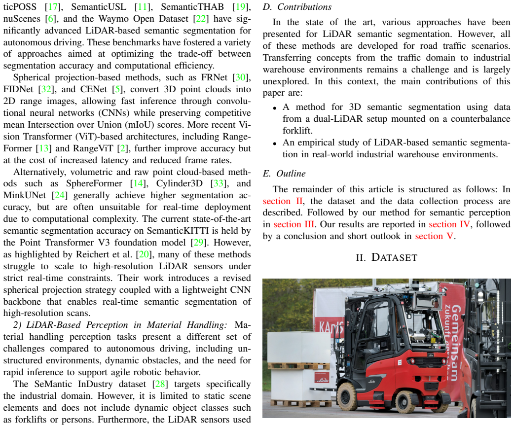
The paper's central claim, stated on its own terms, is that a dual-LiDAR setup consisting of a forward-facing and a downward-angled Ouster OS0-128 scanner, synchronized by precision time protocol, yields a complete enough semantic picture of an outdoor warehouse scene for safe forklift operation. Each scan is projected into an image-like spherical grid expressed in the ISO 8855 vehicle frame, with range, reflectivity, XYZ coordinates, and finite-difference surface normals as input channels. The segmentation head fuses multi-scale backbone features through an attention-weighted feature pyramid and deconvolution upsampling to output a full $128 \times 2048$ label map per sensor. In the experiments, EfficientNet (s) is the best real-time trade-off: 74.14% mIoU, 31 ms for both sensors in one batch, and 22.69M parameters; larger models such as EfficientNet (l) reach 76.21% mIoU but miss the 33.3 ms deadline. The authors also report that reflectivity is what makes lane markings distinguishable and that surface normals separate driveable from non-driveable ground, especially where elevation changes.
Load-bearing premise
The load-bearing assumption is that running the segmentation network once per LiDAR sensor and treating the two outputs as one shared semantic view yields a coherent scene representation, yet the paper never explains how the two per-sensor predictions are merged or how disagreements between the forward and downward views are resolved.
Editorial extensions
If this is right
- A forklift perception stack could receive dense semantic labels for nine classes at 10 Hz from two LiDARs in 31 ms on an RTX 3090, leaving compute headroom inside a 33.3 ms control cycle.
- The reported per-class IoU values imply that safety-critical dynamic classes, not just ground, are separable in real time, with forklift IoU up to 96.72 and person IoU up to 80.04.
- Pre-training on SemanticKITTI followed by fine-tuning on the factory dataset transfers road-scene segmentation to industrial scenes, so a new material-handling site would likely need its own fine-tuning data rather than a new architecture.
- Models heavier than EfficientNet (s), such as EfficientNet (l) with 76.21% mIoU, exceed the dual-sensor latency threshold, so the real-time requirement fixes an upper bound on model capacity for this hardware.
Reading between the lines
- The paper does not specify how the two per-sensor outputs are fused; a natural next experiment, not reported here, is to compare simple concatenation against a learned fusion or conflict-resolution layer on the same test sequence.
- The abstract's claim that the dual configuration improves detection and segmentation of obstacles is not backed by a single-sensor ablation in the reported tables; an ablation would show which classes and spatial regions the downward-angled sensor actually adds.
- The dataset's heavy class imbalance, visible in the logarithmic class-distribution figure, suggests that reported mIoU is pulled by driveable ground; readers should weigh per-class IoU for person and forklift when judging safety performance.
- If surface normals are as decisive as the qualitative results suggest, a testable extension is to feed only geometric channels, such as range, XYZ, and normals, and compare against the full input to isolate reflectivity's contribution to lane-marking IoU.
Editorial analysis
A structured set of objections, weighed in public.
Referee Report
Summary. The paper presents a LiDAR-based semantic segmentation framework for autonomous forklifts in outdoor industrial environments. The system uses two Ouster OS0-128 LiDAR sensors with different mounting angles, projects each scan into a spherical image, and applies CNN backbones (ResNet, ShuffleNet, EfficientNet) with an attention-based feature pyramid network. The authors introduce a dataset, SemanticTHAB, with 7676 annotated scans of a factory site, and report per-class IoU and mIoU on a held-out test sequence. The best trade-off claimed is EfficientNet (s) with 74.14% mIoU and 31 ms dual-sensor inference latency on an RTX 3090, meeting a 33.3 ms real-time constraint.
Significance. If the claims are substantiated, the work would be a useful engineering contribution: a real-time semantic segmentation pipeline for a niche but safety-critical application, plus a new high-resolution industrial LiDAR dataset. The systematic comparison of lightweight backbones on a custom forklift platform is of interest to the robotics and material-handling community. However, the central dual-LiDAR claim is not currently supported by the evidence: no fusion step is defined, no sensor ablation is performed, and no comparison to existing methods is given. The dataset and application framing are valuable, but the paper's central assertion needs additional experimental support before the results can be trusted.
major comments (3)
- [Section III.C.4 and Table III] The paper's central claim that the dual-LiDAR configuration improves detection and segmentation is not supported by the experimental protocol. Inference is described only as running the model with a batch size of two, one scan per sensor; no operation is defined that merges the two spherical projections, no rule resolves conflicting labels in overlapping regions, and Table III does not state whether the reported IoU values are computed on a fused representation or on individual sensors. The 31 ms dual-sensor latency is simply the batched runtime of two independent forward passes. To support the abstract's claim, the authors should either define and evaluate a concrete fusion step or present an ablation comparing single-sensor and dual-sensor accuracy on the same test data.
- [Section IV, Table III] The empirical ranking of backbones is presented without any measure of uncertainty. All mIoU values are point estimates on a single test sequence (0000), and differences such as ResNet50 and EfficientNet (s) both at 74.14% mIoU, or ShuffleNet (l) at 73.91%, are not tested for statistical significance. Since the paper's practical recommendation is based on these small differences, at least standard deviation across multiple runs or a per-sequence breakdown is needed.
- [Section IV, Table III] No existing method is evaluated on the proposed dataset. The related work discusses Schreck et al. [21] and Gonzalez et al. [3] as relevant free-space and obstacle-detection baselines, but the results section compares only the authors' own backbone variants. Without a comparison to at least one prior heuristic or learning-based method on SemanticTHAB, the mIoU values do not establish the claimed advantage over the state of the art that motivates the work.
minor comments (4)
- [Table III] Several numeric entries are concatenated without separators, for example the EfficientNet (m) row reads '61.993.9241.0792.79', making the per-class IoU values unreadable and likely corrupted. Please reformat the table.
- [Section II] 'we utilizePointLabeler' is missing a space, and 'VDBfusion' should be typeset consistently as a software name.
- [Table II and text] The paper uses both 'driveable ground' and 'drivable ground' across the class definitions and narrative; choose one spelling and apply it consistently.
- [Section I.B.1] '270 ° coverage' has a stray space before the degree sign, and the sentence should clarify whether this is a horizontal or vertical field-of-view requirement.
Circularity Check
No circularity: mIoU figures are empirical on a held-out sequence; method components are adopted from cited prior work (including self-citations) rather than derived from the target claim; the dual-sensor gap is an evidence gap, not circular.
full rationale
The paper's central quantitative claims are measurements: Table III reports per-class IoU and mIoU computed via Eq. (4) on test sequence 0000, which is disjoint from training sequences 0001-0003 (Table I). No parameter is fitted to the test labels and then renamed a prediction; the reported 74.14% mIoU is a direct evaluation against manually annotated ground truth. The preprocessing steps (spherical projection Eq. (1), vehicle-frame transform Eq. (2), normal estimation Eq. (3)) are standard geometric operations; they are not defined in terms of the segmentation output, so no equation reduces to its own input. The paper adopts spherical-projection segmentation and normal features 'following [18], [20]' and '[20], [21]' respectively; these are self-citations by overlapping authors, but they supply method components from prior work rather than the paper's conclusion, and the present paper does not invoke them as a uniqueness theorem or as proof of its own accuracy. The lack of a described fusion step for the two LiDAR outputs and the absence of a single-sensor vs. dual-sensor accuracy ablation mean the abstract's dual-configuration benefit is not demonstrated by the experiments; however, that is an evidentiary gap, not a circular derivation. No step in the paper equates a prediction with a fitted input or defines a quantity in terms of its own target.
Assumptions & free parameters
free parameters (3)
- Loss weighting between cross-entropy and Tversky loss =
not reported
- Spherical projection image resolution H x W =
128 x 2048 (implied by Section III.B)
- Fine-tuning epochs (50 pre-train, 30 fine-tune) =
50 / 30
assumptions (5)
- standard math The spherical projection mapping in Eq. (1) and finite-difference surface normals in Eq. (3) are valid for both LiDAR sensors.
- domain assumption The immediate ground is parallel to the forklift's xy-plane defined by ISO 8855 (Section III.A).
- domain assumption Reflectivity is essential for detecting lane markings, and surface normals enhance structure identification (Section III.B).
- domain assumption The test sequence 0000 from the same factory site is representative of the operating environment (Section II).
- domain assumption Pre-training on SemanticKITTI and fine-tuning on the forklift dataset improves performance over training from scratch (Section III.C.2).
Cite this review
Pith. "Pith review of LiDAR Based Semantic Perception for Forklifts in Outdoor Environments." pith.science (2026). https://pith.science/paper/PEDEHTAA
@misc{pith2026250522258,
  author       = {Pith},
  title        = {Pith review of: LiDAR Based Semantic Perception for Forklifts in Outdoor Environments},
  year         = {2026},
  howpublished = {\url{https://pith.science/paper/PEDEHTAA}},
  note         = {Machine review of arXiv:2505.22258}
}
read the original abstract
In this study, we present a novel LiDAR-based semantic segmentation framework tailored for autonomous forklifts operating in complex outdoor environments. Central to our approach is the integration of a dual LiDAR system, which combines forward-facing and downward-angled LiDAR sensors to enable comprehensive scene understanding, specifically tailored for industrial material handling tasks. The dual configuration improves the detection and segmentation of dynamic and static obstacles with high spatial precision. Using high-resolution 3D point clouds captured from two sensors, our method employs a lightweight yet robust approach that segments the point clouds into safety-critical instance classes such as pedestrians, vehicles, and forklifts, as well as environmental classes such as driveable ground, lanes, and buildings. Experimental validation demonstrates that our approach achieves high segmentation accuracy while satisfying strict runtime requirements, establishing its viability for safety-aware, fully autonomous forklift navigation in dynamic warehouse and yard environments.
Figures


Figures from the paper (5 more)



Reference graph
Works this paper leans on
-
[21]
Height change feature based free space detection
Steven Schreck, Hannes Reichert, Manuel Hetzel, Konrad Doll, and Bernhard Sick. Height change feature based free space detection. In2023 11th International Conference on Control, Mechatronics and Automation (ICCMA), pages 171–176, 2023. 2, 3
work page 2023
-
[3]
Dimitrios Arapis, Milad Jami, and Lazaros Nalpantidis. Efficient human 3d localization and free space segmentation for human-aware mobile robots in warehouse facilities.Frontiers in Robotics and AI, 10:1283322, 10 2023. 2
work page 2023
-
[1]
Iñigo Alonso, Luis Riazuelo, Luis Montesano, and Ana Cristina Murillo. 3d-mininet: Learning a 2d representation from point clouds for fast and efficient 3d lidar semantic segmentation.IEEE Robotics and Automation Letters, 5:5432–5439, 2020. 4 Fig. 8:Qualitative Results: Semantic segmentation of point clouds. Lane markings (purple) are clearly distinguisha...
work page 2020
-
[2]
Rangevit: Towards vision transformers for 3d semantic segmentation in autonomous driving
Angelika Ando, Spyros Gidaris, Andrei Bursuc, Gilles Puy, Alexandre Boulch, and Renaud Marlet. Rangevit: Towards vision transformers for 3d semantic segmentation in autonomous driving. InCVPR, 2023. 2
work page 2023
- [4]
-
[5]
Cenet: Toward concise and efficient lidar semantic segmentation for autonomous driv- ing
Hui-Xian Cheng, Xian-Feng Han, and Guo-Qiang Xiao. Cenet: Toward concise and efficient lidar semantic segmentation for autonomous driv- ing. In2022 IEEE International Conference on Multimedia and Expo (ICME), pages 01–06. IEEE, 2022. 2
work page 2022
-
[6]
Panoptic nuscenes: A large-scale benchmark for lidar panoptic segmentation and tracking
Whye Kit Fong, Rohit Mohan, Juana Valeria Hurtado, Lubing Zhou, Holger Caesar, Oscar Beijbom, and Abhinav Valada. Panoptic nuscenes: A large-scale benchmark for lidar panoptic segmentation and tracking. arXiv preprint arXiv:2109.03805, 2021. 2
arXiv 2021
-
[7]
Excavating in the wild: The goose-ex dataset for semantic segmentation
Raphael Hagmanns, Peter Mortimer, Miguel Granero, Thorsten Luettel, and Janko Petereit. Excavating in the wild: The goose-ex dataset for semantic segmentation. 2024. 2
work page 2024
Show all 33 references
-
[8]
Prabhu, S
Seyed Raein Hashemi, Seyed Sadegh Mohseni Salehi, Deniz Erdo ˘gmu¸ s, Sanjay P. Prabhu, S. Warfield, and Ali Gholipour. Tversky as a loss function for highly unbalanced image segmentation using 3d fully convolutional deep networks.ArXiv, abs/1803.11078, 2018. 4
2018 arXiv
-
[9]
Zhang, Shaoqing Ren, and Jian Sun
Kaiming He, X. Zhang, Shaoqing Ren, and Jian Sun. Deep residual learning for image recognition.2016 IEEE Conference on Computer Vision and Pattern Recognition (CVPR), pages 770–778, 2015. 4
2016
-
[10]
ISO 8855:2011 Road vehicles — Vehicle dynamics and road-holding ability — V ocabulary
chassis components ISO/TC 22/SC 33 Vehicle dynamics and driving automation systems testing. ISO 8855:2011 Road vehicles — Vehicle dynamics and road-holding ability — V ocabulary. Standard, Interna- tional Organization for Standardization, Mar. 2011. 3
2011
-
[11]
Lidarnet: A boundary-aware domain adaptation model for lidar point cloud semantic, 2020
Peng Jiang and Srikanth Saripalli. Lidarnet: A boundary-aware domain adaptation model for lidar point cloud semantic, 2020. 2
2020
-
[12]
Kingma and Jimmy Ba
Diederik P. Kingma and Jimmy Ba. Adam: A method for stochastic optimization.CoRR, abs/1412.6980, 2014. 4
2014 arXiv
-
[13]
Rethinking range view representation for lidar segmentation
Lingdong Kong, Youquan Liu, Runnan Chen, Yuexin Ma, Xinge Zhu, Yikang Li, Yuenan Hou, Yu Qiao, and Ziwei Liu. Rethinking range view representation for lidar segmentation. In2023 IEEE/CVF International Conference on Computer Vision (ICCV), pages 228–240, 2023. 2
2023
-
[14]
Spherical transformer for lidar-based 3d recognition
Xin Lai, Yukang Chen, Fanbin Lu, Jianhui Liu, and Jiaya Jia. Spherical transformer for lidar-based 3d recognition. InCVPR, 2023. 2
2023
-
[15]
Feature pyramid networks for object detection
Tsung-Yi Lin, Piotr Dollár, Ross Girshick, Kaiming He, Bharath Hariha- ran, and Serge Belongie. Feature pyramid networks for object detection. In2017 IEEE Conference on Computer Vision and Pattern Recognition (CVPR), pages 936–944, 2017. 4
2017
-
[16]
Inc. Ouster. Ouster - scanning sensors oso - ultra-wide, 2023. Accessed at https://ouster.com/products/scanning-lidar/os0-sensor/ on 2023-05-18. 2
2023
-
[17]
Semanticposs: A point cloud dataset with large quantity of dynamic instances, 2020
Yancheng Pan, Biao Gao, Jilin Mei, Sibo Geng, Chengkun Li, and Huijing Zhao. Semanticposs: A point cloud dataset with large quantity of dynamic instances, 2020. 2
2020
-
[18]
Sensor equivariance by lidar projection images
Hannes Reichert, Manuel Hetzel, Steven Schreck, Konrad Doll, and Bernhard Sick. Sensor equivariance by lidar projection images. In2023 IEEE Intelligent Vehicles Symposium (IV), pages 1–6, 2023. 3
2023
-
[19]
Semanticthab: A high resolution lidar dataset, Feb
Hannes Reichert, Elijah Schüssler, Benjamin Serfling, Kerim Turacan, Konrad Doll, and Bernhard Sick. Semanticthab: A high resolution lidar dataset, Feb. 2025. 2
2025
-
[20]
Real time semantic segmentation of high resolution automotive lidar scans, 2025
Hannes Reichert, Benjamin Serfling, Elijah Schüssler, Kerim Turacan, Konrad Doll, and Bernhard Sick. Real time semantic segmentation of high resolution automotive lidar scans, 2025. 2, 3
2025
-
[22]
Scalability in perception for autonomous driving: Waymo open dataset
Pei Sun, Henrik Kretzschmar, Xerxes Dotiwalla, Aurelien Chouard, Vi- jaysai Patnaik, Paul Tsui, James Guo, Yin Zhou, Yuning Chai, Benjamin Caine, Vijay Vasudevan, Wei Han, Jiquan Ngiam, Hang Zhao, Aleksei Timofeev, Scott Ettinger, Maxim Krivokon, Amy Gao, Aditya Joshi, Yu Zhan...
2020
-
[23]
Efficientnetv2: Smaller models and faster training
Mingxing Tan and Quoc Le. Efficientnetv2: Smaller models and faster training. In Marina Meila and Tong Zhang, editors,Proceedings of the 38th International Conference on Machine Learning, volume 139 ofProceedings of Machine Learning Research, pages 10096–10106. PMLR, 18–24 Jul 2021. 4
2021
-
[24]
Searching efficient 3d architectures with sparse point-voxel convolution
Haotian* Tang, Zhijian* Liu, Shengyu Zhao, Yujun Lin, Ji Lin, Hanrui Wang, and Song Han. Searching efficient 3d architectures with sparse point-voxel convolution. InEuropean Conference on Computer Vision,
-
[25]
Attention is all you need
Ashish Vaswani, Noam Shazeer, Niki Parmar, Jakob Uszkoreit, Llion Jones, Aidan N Gomez, Ł ukasz Kaiser, and Illia Polosukhin. Attention is all you need. In I. Guyon, U. V on Luxburg, S. Bengio, H. Wallach, R. Fergus, S. Vishwanathan, and R. Garnett, editors,Advances in Neural ...
-
[26]
Vdbfusion: Flexible and efficient tsdf integration of range sensor data
Ignacio Vizzo, Tiziano Guadagnino, Jens Behley, and Cyrill Stachniss. Vdbfusion: Flexible and efficient tsdf integration of range sensor data. Sensors, 22(3), 2022. 3
2022
-
[27]
KISS-ICP: In Defense of Point-to- Point ICP – Simple, Accurate, and Robust Registration If Done the Right Way.IEEE Robotics and Automation Letters (RA-L), 8(2):1029–1036,
Ignacio Vizzo, Tiziano Guadagnino, Benedikt Mersch, Louis Wiesmann, Jens Behley, and Cyrill Stachniss. KISS-ICP: In Defense of Point-to- Point ICP – Simple, Accurate, and Robust Registration If Done the Right Way.IEEE Robotics and Automation Letters (RA-L), 8(2):1029–1036,
-
[28]
Sfpnet: Sparse focal point network for semantic segmentation on general lidar point clouds
Yanbo Wang, Wentao Zhao, Chuan Cao, Tianchen Deng, Jingchuan Wang, and Weidong Chen. Sfpnet: Sparse focal point network for semantic segmentation on general lidar point clouds. InEuropean Conference on Computer Vision, pages 403–421. Springer, 2024. 2
2024
-
[29]
Point transformer v3: Simpler, faster, stronger
Xiaoyang Wu, Li Jiang, Peng-Shuai Wang, Zhijian Liu, Xihui Liu, Yu Qiao, Wanli Ouyang, Tong He, and Hengshuang Zhao. Point transformer v3: Simpler, faster, stronger. InCVPR, 2024. 2
2024
-
[30]
Fr- net: Frustum-range networks for scalable lidar segmentation.ArXiv, abs/2312.04484, 2023
Xiang Xu, Lingdong Kong, Hui Shuai, and Qingshan Liu. Fr- net: Frustum-range networks for scalable lidar segmentation.ArXiv, abs/2312.04484, 2023. 2
2023 arXiv
-
[31]
Shufflenet: An extremely efficient convolutional neural network for mobile devices
Xiangyu Zhang, Xinyu Zhou, Mengxiao Lin, and Jian Sun. Shufflenet: An extremely efficient convolutional neural network for mobile devices. In2018 IEEE/CVF Conference on Computer Vision and Pattern Recog- nition, pages 6848–6856, 2018. 4
2018
-
[32]
Yiming Zhao, Lin Bai, and Xinming Huang. Fidnet: Lidar point cloud semantic segmentation with fully interpolation decoding.2021 IEEE/RSJ International Conference on Intelligent Robots and Systems (IROS), pages 4453–4458, 2021. 2
2021
-
[33]
Cylindrical and asymmetri- cal 3d convolution networks for lidar segmentation.arXiv preprint arXiv:2011.10033, 2020
Xinge Zhu, Hui Zhou, Tai Wang, Fangzhou Hong, Yuexin Ma, Wei Li, Hongsheng Li, and Dahua Lin. Cylindrical and asymmetri- cal 3d convolution networks for lidar segmentation.arXiv preprint arXiv:2011.10033, 2020. 2
2011 arXiv
Reviewed August 7, 2026 · model on record in the stance chip above.
Discussion (0). Sign in to comment.