REVIEW 4 major objections 5 minor 2 cited by
A sparse, landmark-free map of stored images and graph edges can match explicit 3D models for multi-session visual navigation, at far lower storage and construction cost.
Reviewed by Pith at T0; open to challenge. T0 means a machine referee read the full paper against a public rubric. the ladder, T0–T4 →
OpenNavMap shows that an image graph plus on-demand 3D reconstruction can match structure-based maps for visual localization and navigation.
T0 review reviewed 2026-08-03 challenge →
load-bearing objection A competent, honest systems paper whose Map-Free and 360Loc results give the core idea real grounding; the multi-session ATE claims rest on ground truth too close to the thing being measured. the 4 major comments →
OpenNavMap: Multi-Session Appearance-Based Topometric Mapping for Scalable Visual Navigation
The pith
A machine-rendered reading of the paper's core claim, the machinery that carries it, and where it could break.
The reading
Core claim
The central discovery is that a sparse observational map can match or exceed a globally consistent 3D map for localization and navigation, provided geometry is generated on demand and filtered by calibrated confidence. The paper shows that pairwise image geometry from a pretrained geometric foundation model, combined with dynamic-programming sequence matching and geometric verification, yields precise relative poses — 0.62 m average translation on the map-free benchmark, with over 80% of queries within 1 m and 10° using two references. It further shows the same machinery can merge 15.7 km of multi-session, multi-device data into one graph with absolute trajectory error under 3 m, and that th
What carries the argument
The carrying object is a three-layer topometric graph: covisibility edges connect overlapping images, odometry edges carry relative poses and covariances, and traversability edges encode feasible motion. Geometry is deliberately absent; when a query arrives, a 3D geometric foundation model predicts dense pointmaps for the query and a handful of co-visible references, and a global optimization with residual-calibrated confidence weighting recovers the query pose and a per-pose covariance. Four mechanisms carry the argument: DP-based sequence matching over a difference matrix that allows jumps between trajectory segments; RANSAC-based geometric verification; the confidence-calibrated optimizat
Load-bearing premise
The headline accuracy numbers rest on ground-truth poses produced by a cloud-based SLAM service that also supplies the local VIO priors used to build the submaps, so if that ground truth carries the same drift the system is meant to correct, the 3 m and 0.62 m figures are not independent measurements of world accuracy.
What would settle it
Recompute the 15.7 km map-merging and metric-localization experiments using independent ground truth (surveyed markers, differential GPS, or a laser-scanned map) instead of the cloud SLAM poses; if the absolute trajectory error exceeds 3 m or average translation error rises above the reported 0.62 m under those independent references, the central claim that sparse maps match 3D models is weakened.
If this is right
- If the claim holds, building a navigable map no longer requires structure-from-motion or LiDAR; a set of overlapping images with phone-level odometry is enough, because geometry is synthesized only when a localization query needs it.
- Localization accuracy becomes mostly a property of the geometric foundation model and the calibration filter, not the density of the map: two reference images already yield sub-meter precision in the tested scenes, so maps can be grown cheaply.
- Multi-session data from phones, vehicle cameras, and street-view panoramas can be merged into one globally consistent graph, so coverage can extend over time without rebuilding a 3D model — the paper demonstrates this on a 15.7 km map with ATE below 3 m.
- The fused topometric graph supports image-goal navigation directly: 12 simulated and physical robot runs reached image-specified goals, suggesting the representation is enough for closed-loop visual navigation in GNSS-denied settings.
- Node culling based on image quality, temporal difference, and information gain cuts map size by roughly 20% with minimal accuracy loss, which matters for long-term deployment.
Where Pith is reading between the lines
- If the system's logic is extended, the real long-term bottleneck is the on-demand geometry model: as that model becomes faster and more robust to appearance change, the whole system's accuracy and cost improve without changing the map representation.
- Because the paper itself notes that DP matching indexes traversal sequences rather than graph topology, one natural next step is to replace sequence indexing with graph- or location-indexed matching, which should improve recall for short, disconnected crowd-sourced clips.
- The calibrated confidence score attached to every loop-closure pose could be exposed to the planner as an uncertainty estimate, enabling risk-aware navigation rather than serving only as a filter before pose graph optimization.
- Given that the reported ATE relies on cloud-SLAM ground truth, an independent survey-based evaluation would be the prudent check before treating the sub-3 m multi-session claim as settled.
Editorial analysis
A structured set of objections, weighed in public.
Referee Report
Summary. The paper proposes OpenNavMap, a structure-free topometric mapping and multi-session localization system. A three-layer graph (covisibility, odometry, traversability) stores images with poses, while geometry is recovered on demand by the MASt3R foundation model. Submaps are aligned through a coarse-to-fine pipeline: DP-based sequence matching, geometric verification, global pose-only optimization with confidence-map calibration, and pose-graph optimization. Cross-device input and probabilistic node culling are added for lifelong operation, and the map is used for image-goal navigation. Experiments are reported on Map-Free, GZ-Campus, 360Loc, and self-collected Aria-glasses datasets, with claims of state-of-the-art metric-localization accuracy, sub-3 m ATE over 15.7 km, and 12 successful navigation trials.
Significance. If the claims hold, the paper is a significant step toward replacing dense 3D maps with sparse, image-only topometric representations for long-term visual navigation. The architecture is clearly specified and modular, the evaluation includes external benchmarks (Map-Free, GZ-Campus, 360Loc) with pretrained models used without fine-tuning, and the map-size analysis is concrete and useful. The real-robot navigation demonstrations and the code/data release commitment are also strengths. However, the load-bearing multi-session consistency claim currently rests on ground truth that is not independent of the system being evaluated, and the headline 0.62 m number is not actually reported in the experimental section. These issues do not invalidate the architecture but they do limit the current evidence for the central claims.
major comments (4)
- [Abstract / §I.C / §VII.B] The abstract and introduction claim a 0.62 m average translation error on Map-Free, but §VII.B reports only Precision@[1m,10°] and AUC curves (Fig. 10). No table or derivation gives the 0.62 m value, nor states the number of reference views, the averaging protocol, or the standard deviation. This number is part of the paper's headline contribution and must be backed by a concrete result in the main text.
- [§VI-B1 / Table IV] The ATE ground truth for the 15.7 km self-collected dataset is generated by Meta's cloud-based SLAM service, while the submaps themselves are built from VIO poses in the same Aria ecosystem. The two may therefore share estimation lineage and drift modes, making the reported <3 m ATE a measure of agreement with a related estimator rather than an independent global-accuracy evaluation. The paper states that the reference has only been 'qualitatively validated' at city scale. Please provide an independent reference for at least a subset (RTK/PPK GNSS, surveyed markers, LiDAR SLAM) or quantify the uncertainty/correlation of the cloud-SLAM reference with the local VIO poses. This is load-bearing for the multi-session scalability claim.
- [Algorithm 1 / Eq. (2)] There is an inconsistency between the DP recurrence in Eq. (2) and the implementation in Algorithm 1. Eq. (2) uses a single jump offset Δ from the previous row, while Algorithm 1 (lines 15–20) allows a jump to any k with |k−i| ≥ Δ, with the same constant penalty λ. The latter makes arbitrarily long jumps as cheap as Δ-length jumps, which can materially affect the matched path and the resulting loop-closure candidates. Please clarify which formulation is actually used, correct the pseudocode or the equation, and report sensitivity to Δ and λ.
- [§IV-B2 / §IV-B3 / Table IV] The PGO in Eq. (7) is weighted by the CCM-derived covariance Σ = diag[(W_i,i · W_i,j)^-2] introduced in §IV-B2. The paper asserts that the mean CCM reflects pose accuracy and uses it to filter loop closures in Fig. 14, but no calibration analysis connects the CCM to true pose error, and no ablation shows that the form of Σ improves the final ATE. Without this, the role of confidence calibration in the <3 m result is not established. Please add a quantitative evaluation of CCM calibration and the effect of the covariance model on PGO output.
minor comments (5)
- [Abstract / §VI-B1] The abstract and §I.C say '19 km dataset', while §VI-B1 says the Aria data total 'over 18.7 km'. Please harmonize these numbers.
- [§IV-A1 / §IV-D2] The covisibility strength v_Cij is defined but never used quantitatively; edge augmentation in §IV-D2 uses keypoint counts. Please clarify whether v_Cij is consumed anywhere or is only a conceptual annotation.
- [§IV-B2 / Eq. (6)] The notation W is used for the per-point robust weight in Eq. (6), but then Σ is defined via 'Wi,i · Wi,j' without a clear definition of these indices. This should be rewritten for readability.
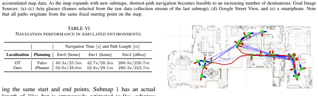
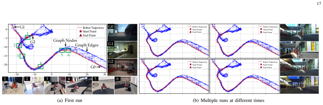
- [§VII-E3 / Fig. 18] The real-world navigation experiments report a single 160 m Lab run with 312 s and multiple repetitions, but there is no quantitative summary table of success rates, path lengths, or completion times across all 12 trials. A compact table would strengthen the navigation claim.
- [§VI-C1] The metric 'Average@1' is defined but never reported or referenced in the results. Either use it in the tables or remove the definition.
Circularity Check
No significant circularity: central results rest on external benchmarks and pre-trained models; self-citations are contextual and the cloud-SLAM ground-truth issue is an evaluation caveat, not a circular derivation.
full rationale
The paper's central quantitative claims are not forced by its inputs. Metric localization is evaluated on public Map-Free (65 scenes), GZ-Campus, and 360Loc datasets with pre-trained MASt3R and no fine-tuning ('all learning-based models were utilized without additional fine-tuning', Sec. VI-A), so Eq. (5)'s pose optimization is not fit to the target errors. The >80% Precision@[1m,10°] with two references and the 0.62m average translation error are external-benchmark results. The multi-session ATE claim (Table IV) is the only headline tied to self-collected data; there, GT comes from Meta's cloud SLAM service (Sec. VI-B1) and the submaps use Aria VIO priors (Sec. IV-A2). This is a real independence/validity concern, but it is not a circularity: the PGO output is not computed from the GT, and the GT's accuracy is supported by an external city-scale study [69]. Self-citations (LiteVLoc [14], GV-Bench [54], MS-Mapping [60]) are related-work/component citations rather than load-bearing premises; no uniqueness theorem or ansatz is imported from the authors' own prior work. No equation-level reduction, no fitted parameter renamed as a prediction, and no self-defined target was found.
Axiom & Free-Parameter Ledger
free parameters (7)
- Keyframe selection thresholds =
3.9 m / 60 deg
- DP matching parameters (velocity set V, jump threshold Delta, jump penalty lambda) =
not specified
- RANSAC inlier threshold for geometric verification =
not specified
- Geman-McClure outlier scale mu =
not specified
- IQA minimum threshold and culling probability threshold =
not specified
- Pose covariance heuristic =
diag[(W_i*W_j)^-2]
- Topological correctness tolerance =
[7.5 m, 75 deg]
axioms (6)
- domain assumption Each device's VIO provides scale-aware, locally consistent poses for submap construction.
- domain assumption Consecutive keyframes are traversable.
- domain assumption Meta Aria cloud-based SLAM poses are accurate enough to serve as ground truth.
- domain assumption MASt3R predicts reliable pointmaps, intrinsics, and confidence maps for uncalibrated cross-device image pairs.
- domain assumption Geographically close images are visually similar enough for descriptor-based retrieval.
- standard math Nonlinear least-squares and PGO converge to a good local minimum.
invented entities (2)
-
Three-layer topometric map (covisibility, odometry, traversability graphs)
independent evidence
-
Calibrated Confidence Map (CCM)
independent evidence
Cite this review
Pith. "Pith review of OpenNavMap: Multi-Session Appearance-Based Topometric Mapping for Scalable Visual Navigation." pith.science (2026). https://pith.science/paper/TUDCHNZ7
@misc{pith2026260112291,
  author       = {Pith},
  title        = {Pith review of: OpenNavMap: Multi-Session Appearance-Based Topometric Mapping for Scalable Visual Navigation},
  year         = {2026},
  howpublished = {\url{https://pith.science/paper/TUDCHNZ7}},
  note         = {Machine review of arXiv:2601.12291}
}
read the original abstract
Scalable and maintainable maps are fundamental to large-scale navigation and the long-term deployment of robots in real-world environments. However, conventional maps that explicitly maintain dense geometry or 3D landmarks incur high storage and maintenance costs, while the core challenge of scaling to multi-session mapping is visual localization under sparse viewpoint overlap, temporal appearance shifts, and cross-device variance. To address this, we propose OpenNavMap, a lightweight, landmark-free topometric mapping system that organizes image nodes into covisibility, odometry, and traversability graphs and delegates local geometry recovery to 3D geometric foundation models (GFMs) on demand. For localization, dynamic-programming-based sequence matching narrows candidate correspondences for a GFM, reducing global estimation to a lightweight, pose-only optimization; for mapping, a lifelong pipeline fuses multi-session, multi-device data via cross-device merging and node culling. On a 19km dataset across four real-world environments, \methodname attains a state-of-the-art $0.62$m translation error on the Map-Free benchmark, bounds the absolute trajectory error below $3$m across 15.7km without depth sensors, and completes $12$ autonomous image-goal visual navigation tasks on both simulated and physical robots. Code and datasets will be made publicly available at https://rpl-cs-ucl.github.io/OpenNavMap_page.
Figures




Forward citations
Cited by 2 Pith papers
-
RA-LWLM: Retrieval-Augmented In-Context Localization with Wireless Foundation Models
RA-LWLM uses retrieval from per-scene databases and in-context learning with a frozen foundation model to achieve cross-scene wireless localization without retraining.
-
G2G: Exploiting Intra-Group Geometry for Inter-Group Pose Estimation
G2G attaches three small trainable modules to frozen backbones and reports state-of-the-art inter-group pose accuracy on four datasets spanning simulation, real cross-season, and sim-to-real transfer using only relati...
Reference graph
Works this paper leans on
-
[1]
Robust collaborative visual-inertial slam for mobile augmented reality,
X. Pan, G. Huang, Z. Zhang, J. Li, H. Bao, and G. Zhang, “Robust collaborative visual-inertial slam for mobile augmented reality,”IEEE Trans. Vis. Comput. Graph., 2024
2024
-
[2]
Map-free visual relocalization: Metric pose relative to a single image,
E. Arnold, J. Wynn, S. Vicente, G. Garcia-Hernando, A. Monszpart, V . Prisacariu, D. Turmukhambetov, and E. Brachmann, “Map-free visual relocalization: Metric pose relative to a single image,” inProc. Eur . Conf. Comput. Vis., 2022, pp. 690–708
2022
-
[3]
Grounding image matching in 3D with MASt3R,
V . Leroy, Y . Cabon, and J. Revaud, “Grounding image matching in 3D with MASt3R,” inProc. Eur . Conf. Comput. Vis., 2024, pp. 71–91
2024
-
[4]
DUSt3R: Geometric 3D vision made easy,
S. Wang, V . Leroy, Y . Cabon, B. Chidlovskii, and J. Revaud, “DUSt3R: Geometric 3D vision made easy,” inProc. IEEE/CVF Conf. Comput. Vis. Pattern Recognit., 2024, pp. 20 697–20 709
2024
-
[5]
VGGT: Visual geometry grounded transformer,
J. Wang, M. Chen, N. Karaev, A. Vedaldi, C. Rupprecht, and D. Novotny, “VGGT: Visual geometry grounded transformer,” inProc. IEEE/CVF Conf. Comput. Vis. Pattern Recognit., 2025, pp. 5294–5306
2025
-
[6]
Learning robust autonomous navigation and locomotion for wheeled- legged robots,
J. Lee, M. Bjelonic, A. Reske, L. Wellhausen, T. Miki, and M. Hutter, “Learning robust autonomous navigation and locomotion for wheeled- legged robots,”Sci. Robot., vol. 9, no. 89, p. eadi9641, 2024
2024
-
[7]
1 year, 1000 km: The oxford robotcar dataset,
W. Maddern, G. Pascoe, C. Linegar, and P. Newman, “1 year, 1000 km: The oxford robotcar dataset,”Int. J. Robot. Res., vol. 36, no. 1, pp. 3–15, 2017
2017
-
[8]
Structure-from-motion revisited,
J. L. Sch ¨onberger and J.-M. Frahm, “Structure-from-motion revisited,” inProc. IEEE/CVF Conf. Comput. Vis. Pattern Recognit., 2016
2016
-
[9]
Crowd- sourced NeRF: Collecting data from production vehicles for 3D street view reconstruction,
T. Qin, C. Li, H. Ye, S. Wan, M. Li, H. Liu, and M. Yang, “Crowd- sourced NeRF: Collecting data from production vehicles for 3D street view reconstruction,”IEEE Trans. Intell. Transp. Syst., 2024
2024
-
[10]
Planet dump retrieved from https://planet.osm.org ,
OpenStreetMap contributors, “Planet dump retrieved from https://planet.osm.org ,” https://www.openstreetmap.org, 2017
2017
-
[11]
Google street view: Capturing the world at street level,
D. Anguelov, C. Dulong, D. Filip, C. Frueh, S. Lafon, R. Lyon, A. Ogale, L. Vincent, and J. Weaver, “Google street view: Capturing the world at street level,”IEEE Computer, vol. 43, no. 6, pp. 32–38, 2010
2010
-
[12]
OrienterNet: Visual localization in 2D public maps with neural match- ing,
P.-E. Sarlin, D. DeTone, T.-Y . Yang, A. Avetisyan, J. Straub, T. Mal- isiewicz, S. R. Bulo, R. Newcombe, P. Kontschieder, and V . Balntas, “OrienterNet: Visual localization in 2D public maps with neural match- ing,” inProc. IEEE/CVF Conf. Comput. Vis. Pattern Recognit., 2023, pp. 21 632–21 642
2023
-
[13]
General place recognition survey: Towards real-world autonomy,
P. Yin, J. Jiao, S. Zhao, L. Xu, G. Huang, H. Choset, S. Scherer, and J. Han, “General place recognition survey: Towards real-world autonomy,”IEEE Trans. Robot., 2025
2025
-
[14]
LiteVLoc: Map-lite visual localization for image goal navigation,
J. Jiao, J. He, C. Liu, S. Aegidius, X. Hu, T. Braud, and D. Kanoulas, “LiteVLoc: Map-lite visual localization for image goal navigation,” in Proc. IEEE Int. Conf. Robot. Autom., 2025
2025
-
[15]
Hydra: A real-time spatial perception system for 3D scene graph construction and optimization,
N. Hughes, Y . Chang, and L. Carlone, “Hydra: A real-time spatial perception system for 3D scene graph construction and optimization,” arXiv preprint arXiv:2201.13360, 2022
Pith/arXiv arXiv 2022
-
[16]
Visual teach and repeat for long-range rover autonomy,
P. Furgale and T. D. Barfoot, “Visual teach and repeat for long-range rover autonomy,”J. Field Robot., vol. 27, no. 5, pp. 534–560, 2010
2010
-
[17]
Project Aria: A new tool for egocentric multi-modal ai research,
J. Engelet al., “Project Aria: A new tool for egocentric multi-modal ai research,”arXiv preprint arXiv:2308.13561, 2023
Pith/arXiv arXiv 2023
-
[18]
Carlone, A
L. Carlone, A. Kim, F. Dellaert, T. Barfoot, and D. Cremers,SLAM Handbook. From Localization and Mapping to Spatial Intelligence, L. Carlone, A. Kim, F. Dellaert, T. Barfoot, and D. Cremers, Eds. Cambridge University Press, 2024
2024
-
[19]
ORB-SLAM: A versatile and accurate monocular SLAM system,
R. Mur-Artal, J. M. M. Montiel, and J. D. Tardos, “ORB-SLAM: A versatile and accurate monocular SLAM system,”IEEE Trans. Robot., vol. 31, no. 5, pp. 1147–1163, 2015
2015
-
[20]
Fast-LIVO2: Fast, direct lidar-inertial-visual odometry,
C. Zheng, W. Xu, Z. Zou, T. Hua, C. Yuan, D. He, B. Zhou, Z. Liu, J. Lin, F. Zhuet al., “Fast-LIVO2: Fast, direct lidar-inertial-visual odometry,”IEEE Trans. Robot., 2024
2024
-
[21]
3D gaussian splatting for real-time radiance field rendering,
B. Kerbl, G. Kopanas, T. Leimk ¨uhler, and G. Drettakis, “3D gaussian splatting for real-time radiance field rendering,”ACM Trans. Graph., vol. 42, no. 4, pp. 1–14, 2023
2023
-
[22]
Graph-based subterranean exploration path planning using aerial and legged robots,
T. Dang, M. Tranzatto, S. Khattak, F. Mascarich, K. Alexis, and M. Hutter, “Graph-based subterranean exploration path planning using aerial and legged robots,”J. Field Robot., vol. 37, no. 8, pp. 1363–1388, 2020
2020
-
[23]
Rethinking visual geo- localization for large-scale applications,
G. Berton, C. Masone, and B. Caputo, “Rethinking visual geo- localization for large-scale applications,” inProc. IEEE/CVF Conf. Comput. Vis. Pattern Recognit., 2022, pp. 4878–4888
2022
-
[24]
GNM: A general navigation model to drive any robot,
D. Shah, A. Sridhar, A. Bhorkar, N. Hirose, and S. Levine, “GNM: A general navigation model to drive any robot,” inProc. IEEE Int. Conf. Robot. Autom., 2023, pp. 7226–7233
2023
-
[25]
NeRF in the wild: Neural radiance fields for unconstrained photo collections,
R. Martin-Brualla, N. Radwan, M. S. Sajjadi, J. T. Barron, A. Doso- vitskiy, and D. Duckworth, “NeRF in the wild: Neural radiance fields for unconstrained photo collections,” inProc. IEEE/CVF Conf. Comput. Vis. Pattern Recognit., 2021, pp. 7210–7219
2021
-
[26]
Accelerated coordi- nate encoding: Learning to relocalize in minutes using RGB and poses,
E. Brachmann, T. Cavallari, and V . A. Prisacariu, “Accelerated coordi- nate encoding: Learning to relocalize in minutes using RGB and poses,” inProc. IEEE/CVF Conf. Comput. Vis. Pattern Recognit., 2023, pp. 5044–5053. 20
2023
-
[27]
Vision-only robot navigation in a neural radiance world,
M. Adamkiewicz, T. Chen, A. Caccavale, R. Gardner, P. Culbertson, J. Bohg, and M. Schwager, “Vision-only robot navigation in a neural radiance world,”IEEE Robot. Autom. Lett., vol. 7, no. 2, pp. 4606–4613, 2022
2022
-
[28]
Kimera: From SLAM to spatial perception with 3D dynamic scene graphs,
A. Rosinol, A. Violette, M. Abate, N. Hughes, Y . Chang, J. Shi, A. Gupta, and L. Carlone, “Kimera: From SLAM to spatial perception with 3D dynamic scene graphs,”Int. J. Robot. Res., vol. 40, no. 12-14, pp. 1510–1546, 2021
2021
-
[29]
S-graphs+: Real-time localization and mapping leveraging hierarchical representations,
H. Bavle, J. L. Sanchez-Lopez, M. Shaheer, J. Civera, and H. V oos, “S-graphs+: Real-time localization and mapping leveraging hierarchical representations,”IEEE Robot. Autom. Lett., vol. 8, no. 8, pp. 4927–4934, 2023
2023
-
[30]
Bridging the appearance gap: Multi-experience localization for long-term visual teach and repeat,
M. Paton, K. MacTavish, M. Warren, and T. D. Barfoot, “Bridging the appearance gap: Multi-experience localization for long-term visual teach and repeat,” inProc. IEEE/RSJ Int. Conf. Intell. Robots Syst., 2016, pp. 1918–1925
2016
-
[31]
Experience-based navigation for long- term localisation,
W. Churchill and P. Newman, “Experience-based navigation for long- term localisation,”Int. J. Robot. Res., vol. 32, no. 14, pp. 1645–1661, 2013
2013
-
[32]
Bags of binary words for fast place recognition in image sequences,
D. G ´alvez-L´opez and J. D. Tardos, “Bags of binary words for fast place recognition in image sequences,”IEEE Trans. Robot., vol. 28, no. 5, pp. 1188–1197, 2012
2012
-
[33]
NetVLAD: CNN architecture for weakly supervised place recognition,
R. Arandjelovi ´c, P. Gron´at, A. Torii, T. Pajdla, and J. Sivic, “NetVLAD: CNN architecture for weakly supervised place recognition,” inProc. IEEE/CVF Conf. Comput. Vis. Pattern Recognit., 2016, pp. 5297–5307
2016
-
[34]
SeqSLAM: Visual route-based naviga- tion for sunny summer days and stormy winter nights,
M. J. Milford and G. F. Wyeth, “SeqSLAM: Visual route-based naviga- tion for sunny summer days and stormy winter nights,” inProc. IEEE Int. Conf. Robot. Autom., 2012, pp. 1643–1649
2012
-
[35]
Lazy data association for image se- quences matching under substantial appearance changes,
O. Vysotska and C. Stachniss, “Lazy data association for image se- quences matching under substantial appearance changes,”IEEE Robot. Autom. Lett., vol. 1, no. 1, pp. 213–220, 2015
2015
-
[36]
SeqNet: Learning descriptors for sequence- based hierarchical place recognition,
S. Garg and M. Milford, “SeqNet: Learning descriptors for sequence- based hierarchical place recognition,”IEEE Robot. Autom. Lett., vol. 6, no. 3, pp. 4305–4312, 2021
2021
-
[37]
Modeling perceptual aliasing in slam via discrete–continuous graphical models,
P.-Y . Lajoie, S. Hu, G. Beltrame, and L. Carlone, “Modeling perceptual aliasing in slam via discrete–continuous graphical models,”IEEE Robot. Autom. Lett., vol. 4, no. 2, pp. 1232–1239, 2019
2019
-
[38]
SlideSLAM: Sparse, lightweight, decen- tralized metric-semantic slam for multi-robot navigation,
X. Liu, J. Lei, A. Prabhu, Y . Tao, I. Spasojevic, P. Chaudhari, N. Atanasov, and V . Kumar, “SlideSLAM: Sparse, lightweight, decen- tralized metric-semantic slam for multi-robot navigation,”arXiv preprint arXiv:2406.17249, 2024
arXiv 2024
-
[39]
Kimera-Multi: Robust, distributed, dense metric-semantic slam for multi-robot systems,
Y . Tian, Y . Chang, F. H. Arias, C. Nieto-Granda, J. P. How, and L. Carlone, “Kimera-Multi: Robust, distributed, dense metric-semantic slam for multi-robot systems,”IEEE Trans. Robot., vol. 38, no. 4, 2022
2022
-
[40]
Complete solution clas- sification for the perspective-three-point problem,
X. Gao, X. Hou, J. Tang, and H.-F. Cheng, “Complete solution clas- sification for the perspective-three-point problem,”IEEE Trans. Pattern Anal. Mach. Intell., vol. 25, pp. 930–943, 2003
2003
-
[41]
Random sample consensus: a paradigm for model fitting with applications to image analysis and automated cartography,
M. A. Fischler and R. C. Bolles, “Random sample consensus: a paradigm for model fitting with applications to image analysis and automated cartography,”Commun. ACM, vol. 24, no. 6, pp. 381–395, 1981
1981
-
[42]
Multi-session slam with differentiable wide- baseline pose optimization,
L. Lipson and J. Deng, “Multi-session slam with differentiable wide- baseline pose optimization,” inProc. IEEE/CVF Conf. Comput. Vis. Pattern Recognit., 2024, pp. 19 626–19 635
2024
-
[43]
CVI-SLAM—collaborative visual- inertial SLAM,
M. Karrer, P. Schmuck, and M. Chli, “CVI-SLAM—collaborative visual- inertial SLAM,”IEEE Robot. Autom. Lett., vol. 3, no. 4, pp. 2762–2769, 2018
2018
-
[44]
D2SLAM: Decentralized and distributed collaborative visual-inertial SLAM system for aerial swarm,
H. Xu, P. Liu, X. Chen, and S. Shen, “D2SLAM: Decentralized and distributed collaborative visual-inertial SLAM system for aerial swarm,” IEEE Trans. Robot., 2024
2024
-
[45]
PoseNet: A convolutional network for real-time 6-dof camera relocalization,
A. Kendall, M. Grimes, and R. Cipolla, “PoseNet: A convolutional network for real-time 6-dof camera relocalization,” inProc. IEEE/CVF Int. Conf. Comput. Vis., 2015, pp. 2938–2946
2015
-
[46]
R-SCoRe: Revisiting scene coordinate regression for robust large-scale visual localization,
X. Jiang, F. Wang, S. Galliani, C. V ogel, and M. Pollefeys, “R-SCoRe: Revisiting scene coordinate regression for robust large-scale visual localization,” inProc. IEEE/CVF Conf. Comput. Vis. Pattern Recognit., 2025
2025
-
[47]
LaMAR: Benchmarking localization and mapping for augmented reality,
P.-E. Sarlin, M. Dusmanu, J. L. Sch ¨onberger, P. Speciale, L. Gruber, V . Larsson, O. Miksik, and M. Pollefeys, “LaMAR: Benchmarking localization and mapping for augmented reality,” inProc. Eur . Conf. Comput. Vis., 2022, pp. 686–704
2022
-
[48]
FusionPortableV2: A unified multi-sensor dataset for generalized SLAM across diverse platforms and scalable environments,
H. Wei, J. Jiao, X. Hu, J. Yu, X. Xie, J. Wu, Y . Zhu, Y . Liu, L. Wang, and M. Liu, “FusionPortableV2: A unified multi-sensor dataset for generalized SLAM across diverse platforms and scalable environments,” Int. J. Robot. Res., p. 02783649241303525, 2024
2024
-
[49]
CroCoDL: Cross-device collaborative dataset for localization,
H. Blum, A. Mercurio, J. O’Reilly, T. Engelbracht, M. Dusmanu, M. Pollefeys, and Z. Bauer, “CroCoDL: Cross-device collaborative dataset for localization,” inProc. IEEE/CVF Conf. Comput. Vis. Pattern Recognit., 2025, pp. 27 424–27 434
2025
-
[50]
360Loc: A dataset and benchmark for omnidirectional visual local- ization with cross-device queries,
H. Huang, C. Liu, Y . Zhu, H. Cheng, T. Braud, and S.-K. Yeung, “360Loc: A dataset and benchmark for omnidirectional visual local- ization with cross-device queries,” inProc. IEEE/CVF Conf. Comput. Vis. Pattern Recognit., 2024, pp. 22 314–22 324
2024
-
[51]
Xoftr: Cross-modal feature matching transformer,
¨O. Tuzcuo˘glu, A. K ¨oksal, B. Sofu, S. Kalkan, and A. A. Alatan, “Xoftr: Cross-modal feature matching transformer,” inProc. IEEE/CVF Conf. Comput. Vis. Pattern Recognit., 2024, pp. 4275–4286
2024
-
[52]
Matchanything: Universal cross-modality image matching with large- scale pre-training,
X. He, H. Yu, S. Peng, D. Tan, Z. Shen, H. Bao, and X. Zhou, “Matchanything: Universal cross-modality image matching with large- scale pre-training,”arXiv preprint arXiv:2501.07556, 2025
Pith/arXiv arXiv 2025
-
[53]
LoRA3D: Low-rank self-calibration of 3D geometric foundation mod- els,
Z. Lu, H. Yang, D. Xu, B. Li, B. Ivanovic, M. Pavone, and Y . Wang, “LoRA3D: Low-rank self-calibration of 3D geometric foundation mod- els,” inInt. Conf. Learn. Represent., 2025
2025
-
[54]
GV-Bench: Benchmarking local feature matching for geometric verification of long-term loop closure detection,
J. Yu, H. Ye, J. Jiao, P. Tan, and H. Zhang, “GV-Bench: Benchmarking local feature matching for geometric verification of long-term loop closure detection,” inProc. IEEE/RSJ Int. Conf. Intell. Robots Syst., 2024, pp. 7922–7928
2024
-
[55]
From coarse to fine: Robust hierarchical localization at large scale,
P.-E. Sarlin, C. Cadena, R. Siegwart, and M. Dymczyk, “From coarse to fine: Robust hierarchical localization at large scale,” inProc. IEEE/CVF Conf. Comput. Vis. Pattern Recognit., 2019
2019
-
[56]
borglab/gtsam,
F. Dellaert and G. Contributors, “borglab/gtsam,” 2022. [Online]. Available: https://github.com/borglab/gtsam)
2022
-
[57]
MUSIQ: Multi- scale image quality transformer,
J. Ke, Q. Wang, Y . Wang, P. Milanfar, and F. Yang, “MUSIQ: Multi- scale image quality transformer,” inProc. IEEE/CVF Int. Conf. Comput. Vis., 2021, pp. 5148–5157
2021
-
[58]
SLiM: Scalable and lightweight lidar mapping in urban environments,
Z. Yu, Z. Qiao, W. Liu, H. Yin, and S. Shen, “SLiM: Scalable and lightweight lidar mapping in urban environments,”IEEE Trans. Robot., 2025
2025
-
[59]
VINS-Mono: A robust and versatile monocular visual-inertial state estimator,
T. Qin, P. Li, and S. Shen, “VINS-Mono: A robust and versatile monocular visual-inertial state estimator,”IEEE Trans. Robot., vol. 34, no. 4, pp. 1004–1020, 2018
2018
-
[60]
MS-Mapping: Multi- session lidar mapping with wasserstein-based keyframe selection,
X. Hu, J. Wu, J. Jiao, W. Zhang, and P. Tan, “MS-Mapping: Multi- session lidar mapping with wasserstein-based keyframe selection,”arXiv preprint arXiv:2406.02096, 2024
Pith/arXiv arXiv 2024
-
[61]
Watch your STEPP: Semantic traversability estimation using pose projected features,
S. Ægidius, D. Hadjivelichkov, J. Jiao, J. Embley-Riches, and D. Kanoulas, “Watch your STEPP: Semantic traversability estimation using pose projected features,” inProc. IEEE Int. Conf. Robot. Autom., 2025, pp. 2376–2382
2025
-
[62]
EigenPlaces: Training viewpoint robust models for visual place recognition,
G. Berton, G. Trivigno, B. Caputo, and C. Masone, “EigenPlaces: Training viewpoint robust models for visual place recognition,” inProc. IEEE/CVF Int. Conf. Comput. Vis., 2023, pp. 11 080–11 090
2023
-
[63]
AnyLoc: Towards universal visual place recognition,
N. Keetha, A. Mishra, J. Karhade, K. M. Jatavallabhula, S. Scherer, M. Krishna, and S. Garg, “AnyLoc: Towards universal visual place recognition,”IEEE Robot. Autom. Lett., vol. 9, no. 2, pp. 1286–1293, 2023
2023
-
[64]
Megaloc: One retrieval to place them all,
G. Berton and C. Masone, “Megaloc: One retrieval to place them all,” in Proc. IEEE/CVF Conf. Comput. Vis. Pattern Recognit., 2025, pp. 2861– 2867
2025
-
[65]
Falco: Fast likelihood- based collision avoidance with extension to human-guided navigation,
J. Zhang, C. Hu, R. G. Chadha, and S. Singh, “Falco: Fast likelihood- based collision avoidance with extension to human-guided navigation,” J. Field Robot., vol. 37, no. 8, pp. 1300–1313, 2020
2020
-
[66]
Matterport3D: Learning from RGB- D data in indoor environments,
A. Chang, A. Dai, T. Funkhouser, M. Halber, M. Niebner, M. Savva, S. Song, A. Zeng, and Y . Zhang, “Matterport3D: Learning from RGB- D data in indoor environments,” inProc. Int. Conf. 3D Vis., 2017, pp. 667–676
2017
-
[67]
iPlanner: Imperative path planning,
F. Yang, C. Wang, C. Cadena, and M. Hutter, “iPlanner: Imperative path planning,”arXiv preprint arXiv:2302.11434, 2023
arXiv 2023
-
[68]
State estimation for legged robots-kinematics, inertial sensing, and computer vision,
M. Bloesch, “State estimation for legged robots-kinematics, inertial sensing, and computer vision,” Ph.D. dissertation, ETH Zurich, 2017
2017
-
[69]
Benchmarking egocentric visual-inertial SLAM at city scale,
A. Krishnan, S. Liu, P.-E. Sarlin, O. Gentilhomme, D. Caruso, M. Monge, R. Newcombe, J. Engel, and M. Pollefeys, “Benchmarking egocentric visual-inertial SLAM at city scale,” inProc. IEEE/CVF Int. Conf. Comput. Vis., 2025, pp. 25 207–25 217
2025
-
[70]
MARViN: Mobile AR dataset with visual-inertial data,
C. Liu, Y . Zhao, and T. Braud, “MARViN: Mobile AR dataset with visual-inertial data,” inProc. IEEE Conf. Virtual Real. 3D User Inter- faces Abstr . Workshops, 2024, pp. 532–538
2024
-
[71]
Supplementary Materials of OpenNavMap: Structure-Free Topometric Mapping via Large-Scale Collaborative Localization,
J. Jiaoet al., “Supplementary Materials of OpenNavMap: Structure-Free Topometric Mapping via Large-Scale Collaborative Localization,” 2025
2025
-
[72]
A tutorial on quantitative trajectory evaluation for visual (-inertial) odometry,
Z. Zhang and D. Scaramuzza, “A tutorial on quantitative trajectory evaluation for visual (-inertial) odometry,” inProc. IEEE/RSJ Int. Conf. Intell. Robots Syst., 2018, pp. 7244–7251
2018
-
[73]
End-to-end learning of deep visual representations for image retrieval,
A. Gordo, J. Almazan, J. Revaud, and D. Larlus, “End-to-end learning of deep visual representations for image retrieval,”Int. J. Comput. Vis., vol. 124, no. 2, pp. 237–254, 2017. 21
2017
-
[74]
DISK: Learning local features with policy gradient,
M. Tyszkiewicz, P. Fua, and E. Trulls, “DISK: Learning local features with policy gradient,” inAdv. Neural Inf. Process. Syst., vol. 33, 2020, pp. 14 254–14 265
2020
-
[75]
SuperPoint: Self- supervised interest point detection and description,
D. DeTone, T. Malisiewicz, and A. Rabinovich, “SuperPoint: Self- supervised interest point detection and description,” inProc. IEEE Conf. Comput. Vis. Pattern Recognit. Workshops, 2018, pp. 224–236
2018
-
[76]
LightGlue: Local feature matching at light speed,
P. Lindenberger, P.-E. Sarlin, and M. Pollefeys, “LightGlue: Local feature matching at light speed,” inProc. IEEE/CVF Int. Conf. Comput. Vis., 2023, pp. 17 627–17 638
2023
-
[77]
Reloc3r: Large-scale training of relative camera pose regression for generalizable, fast, and accurate visual localization,
S. Dong, S. Wang, S. Liu, L. Cai, Q. Fan, J. Kannala, and Y . Yang, “Reloc3r: Large-scale training of relative camera pose regression for generalizable, fast, and accurate visual localization,” inProc. IEEE/CVF Conf. Comput. Vis. Pattern Recognit., 2025, pp. 16 739–16 752
2025
-
[78]
MV-Dust3r+: Single-stage scene reconstruction from sparse views in 2 seconds,
Z. Tang, Y . Fan, D. Wang, H. Xu, R. Ranjan, A. Schwing, and Z. Yan, “MV-Dust3r+: Single-stage scene reconstruction from sparse views in 2 seconds,” inProc. IEEE/CVF Conf. Comput. Vis. Pattern Recognit., 2025, pp. 5283–5293
2025
-
[79]
LoFTR: Detector-free local feature matching with transformers,
J. Sun, Z. Shen, Y . Wang, H. Bao, and X. Zhou, “LoFTR: Detector-free local feature matching with transformers,” inProc. IEEE/CVF Conf. Comput. Vis. Pattern Recognit., 2021, pp. 8922–8931
2021
-
[80]
SceneGraphLoc: Cross-modal coarse visual localization on 3D scene graphs,
Y . Miao, F. Engelmann, O. Vysotska, F. Tombari, M. Pollefeys, and D. B. Bar ´ath, “SceneGraphLoc: Cross-modal coarse visual localization on 3D scene graphs,” inProc. Eur . Conf. Comput. Vis., 2024, pp. 127– 150
2024
This paper was first reviewed by deepseek-v4-flash on August 3, 2026.
discussion (0)
Sign in with ORCID, Apple, or X to comment. Anyone can read and Pith papers without signing in.