REVIEW 3 major objections 5 minor 2 cited by
Contrasting local and global modeling with machine learning and satellite data: A case study estimating tree canopy height in African savannas
T0 review · 3 major / 5 minor · reviewed 2026-08-12 · deepseek-v4-flash
Pith's one-line read In the Karingani Game Reserve, a small model trained only on local LiDAR labels and Sentinel-2 imagery predicts tree canopy height more accurately than four published global maps and more accurately than globally pretrained models…
desk verdict Solid case study showing local FCN beats global TCH maps in Mozambican savanna; the fine-tuning comparison is under-supported because only the last 3 layers of XceptionS2 were tuned. read the letter →
The pith
A machine-rendered reading of the paper's core claim, the machinery that carries it, and where it could break.
The reading
What carries the argument
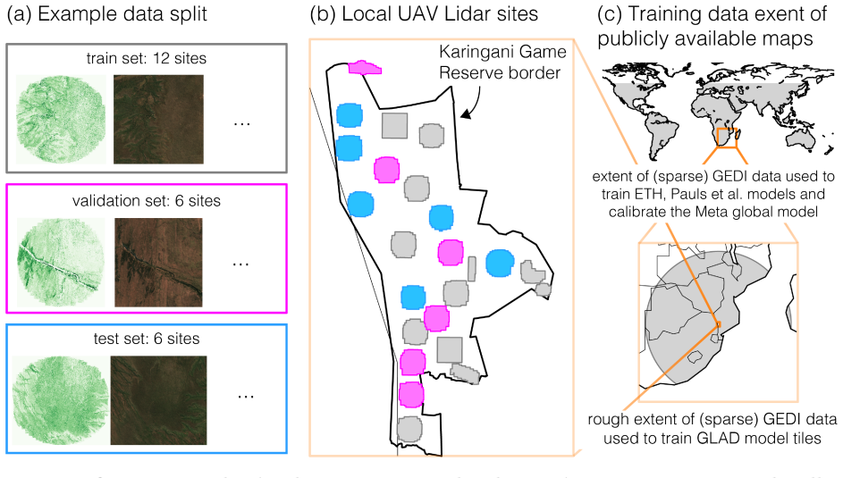
The load-bearing object is a five-layer fully convolutional network with 128 filters per layer, roughly 604,417 parameters, and an 11-by-11-pixel receptive field, trained from scratch on 12-band Sentinel-2 imagery with UAV-LiDAR-derived tree canopy height labels as supervision. The experimental design also depends on site-stratified train, validation, and test splits across 24 surveyed sites, which force every reported error metric to reflect prediction at sites never seen during training or validation.
What would settle it
Collect new UAV-LiDAR data over sites outside the existing 24 in Karingani, or in a comparable savanna reserve, and compare the locally trained fully convolutional network's predictions against the Pauls et al. map on those sites; if the gap in RMSE largely disappears or reverses, the claim that local training is decisive for local accuracy would be refuted.
Extended reading notes
Core claim
The central claim is that, for mapping tree canopy height in this savanna region, local modeling and global modeling are currently distinct goals: a model trained from scratch on local data outperforms both published global maps and globally pretrained models fine-tuned on the same local data. The paper reaches this conclusion through site-disjoint train, validation, and test splits over 24 UAV-LiDAR survey sites, so every reported result is out-of-sample with respect to whole sites. It also finds that the best global map in Karingani is not the newest one, that the choice of model architecture, input spectral bands, and amount of training data each affect performance by similar magnitudes, and that while local data are essential for evaluation, straightforward fine-tuning of global models does not substitute for training a small local model.
Load-bearing premise
The 24 LiDAR-surveyed sites are representative enough of the whole Karingani Game Reserve that the held-out test sites measure how the models will behave in the roughly two-thirds of the reserve without flight data.
Editorial extensions
If this is right
- Locally collected high-fidelity labels, not global pretraining, are the decisive resource for accurate canopy height maps in this savanna; improving global models will not automatically improve local mapping.
- Fine-tuning a globally pretrained model on local data provides little or no benefit over training a small local model from scratch, so transfer-learning pipelines should be benchmarked against local-only training before being adopted.
- Global map quality rankings do not transfer to local quality rankings, since the older 30 m GLAD map can beat newer global maps in a specific region; local validation data remain necessary even when global maps look good globally.
- Design choices that help global performance, such as absolute location embeddings, can be neutral or harmful for local spatial extrapolation, so local models need their own design validation with site-disjoint splits.
Reading between the lines
- Inference: if the local-data advantage holds beyond this reserve, the marginal value of a global model for local applications may be small, and collection of local LiDAR or equivalent ground-referenced data should be prioritized over further global-pretraining investment.
- Inference: the results suggest a testable scaling law—as the local training footprint grows past some radius, the local-only advantage over global maps should shrink, and mapping that crossover would tell practitioners when global models become cost-effective.
- Inference: the failure of absolute location embeddings hints that spatial extrapolation may require relative or learned positional encodings rather than absolute coordinates, a hypothesis the paper does not directly test.
- Inference: replicating the study in a different biome, such as a dense tropical forest or a boreal landscape, would separate savanna-specific effects from a general local-versus-global discrepancy in geospatial machine learning.
Editorial analysis
A structured set of objections, weighed in public.
Referee Report
Summary. This paper uses a case study of tree canopy height (TCH) mapping in Karingani Game Reserve, Mozambique, to contrast local and global training paradigms in satellite machine learning. The authors compare (i) four published global TCH maps evaluated out of the box, (ii) locally trained models (a small FCN, a U-Net, an XceptionS2, and a random forest) trained from scratch on local UAV-LiDAR labels, and (iii) globally pretrained models (XceptionS2 with supervised global TCH weights and U-Net with SSL4EO self-supervised weights) fine-tuned on local data. Using spatially disjoint site-stratified splits, they find that a small locally trained FCN achieves the best RMSE (1.64 m), outperforming the best global map (Pauls et al., 2.43 m) and the best fine-tuned global model (XceptionS2 with global initialization, 1.98 m). They also analyze the relative influence of training data quantity, spectral bands, and model architecture, and discuss points of conflict and synergy between local and global modeling.
Significance. The evaluation design is a strength: spatially disjoint site-stratified splits (four splits), ten random seeds per model, comparison against four published global maps, and error stratification by height, geology, and distance to rivers provide a rigorous benchmark. The downstream aboveground biomass calibration analysis (Section 5.1.3) is a useful additional check of practical utility. If the main finding survives, it provides concrete evidence that local high-fidelity labels can outweigh global pretraining for this task, with implications for data collection and model design in geospatial ML. The paper also delivers falsifiable predictions and transparent metrics.
major comments (3)
- [§4.2.2, Table 1, Table 2] The claim in the abstract and Section 5.2 that locally trained models 'even outperform globally pretrained models that we fine-tune using local data' is not fully supported because the only supervised global TCH model with available weights (XceptionS2) is fine-tuned only in its last 1–3 layers (Section 4.2.2; Table 2), rather than fully fine-tuned. The RMSE gap between the best fine-tuned XceptionS2 (1.98 m) and the local FCN (1.64 m) is 0.34 m, which could close if earlier layers were allowed to adapt, especially since the global model's early layers and positional embeddings were optimized on global data. Please add a full fine-tuning condition (or at least a condition tuning a substantially larger portion of the network) or restrict the claim to the specific fine-tuning protocols used.
- [§4.2.2, Abstract, §5.2] The fine-tuning comparison is also limited by model availability: among the four recent global maps, only the ETH/XceptionS2 model weights are publicly available; the Pauls et al. weights are not released, and the Meta model would require proprietary imagery for fine-tuning. Thus the conclusion that 'globally pretrained models are not necessarily the right starting point' (Section 6.3) is based on a single supervised global TCH model and one self-supervised U-Net. The paper should state this limitation more prominently and frame the conclusion as specific to the models and protocols tested.
- [§3.3, §6.1] The evaluation is confined to the 24 UAV-LiDAR sites; no independent data are available for the roughly two-thirds of Karingani not covered by flight data. The site-stratified splits simulate deployment to new sites, but they cannot validate the model on truly unseen portions of the reserve if those areas differ systematically in vegetation or geology from the 24 sites. The paper acknowledges coverage gaps but the abstract's unqualified statement that local models 'outperform published global TCH maps' in the study region should be scoped to the evaluated sites or supplemented with an explicit acknowledgment of this limitation.
minor comments (5)
- [§5.1.1] 'RSME' should be 'RMSE'; also the reported local FCN RMSE is given as 1.65 in the bullet list but 1.64 in Table 1 – please align.
- [§6.1] 'Karangani' is spelled 'Karingani' elsewhere; fix the typo.
- [Table 2 caption, Table 3] 'XcpetionS2' should be 'XceptionS2'.
- [§4.2.2] The choice to stop at 'last 3 layers' after observing small differences between 2 and 3 layers is not a substitute for a full fine-tuning sweep; please add a sentence justifying this choice (e.g., computational budget) or report the full sweep.
- [Table 1] The paper does not report statistical significance tests comparing the local FCN RMSE to the best fine-tuned model; given the small standard deviations across seeds (0.01 vs 0.03 m), a paired test across splits would strengthen the claim.
Circularity Check
No significant circularity: the local-vs-global TCH comparison rests on external global maps and independent local LiDAR labels.
full rationale
The paper's central claim—that a small local-only FCN (RMSE 1.64 m) outperforms published global TCH maps (best 2.43 m) and locally fine-tuned global models (best 1.98 m)—is established by comparing predictions against held-out UAV-LiDAR labels at spatially disjoint test sites (Section 3.3, Section 4.2.4, Table 1). The global maps are external public products (GLAD, ETH, Meta, Pauls et al.) and the local labels are independent of the authors' prior results; no parameter is fitted to the test labels, and no equation in the paper defines the predicted quantity in terms of the comparison metric. The XceptionS2 fine-tuning choice (tuning only the last 3 layers, Section 4.2.2) is a modeling decision that may understate the value of global pretraining, but that is a validity/robustness concern, not circularity: the comparison is not forced by construction. Self-citations (Rolf et al. 2022; Rolf 2023; Rolf et al. 2024; Aiken et al. 2023) appear in contextual framing and evaluation-practice discussion, but none is load-bearing for the empirical result, which is self-contained against external benchmarks. No circular step is exhibited.
Assumptions & free parameters
free parameters (5)
- LiDAR label cap at 30 m =
30 m
- 90th percentile coarsening of labels =
90th percentile
- Number of XceptionS2 layers fine-tuned =
3 layers
- U-Net evaluation margin =
innermost 4x4 pixels per 64x64 patch
- FCN architecture size =
5 layers, 128 filters
assumptions (4)
- domain assumption UAV-LiDAR canopy height model (Boucher et al. 2023) provides accurate reference TCH.
- domain assumption The 24 LiDAR sites represent the full Karingani reserve.
- domain assumption Sentinel-2 12-band imagery is sufficient for local TCH prediction.
- domain assumption Allometric equation F from Colgan et al. 2013 is valid for savanna AGB estimation.
Cite this review
Pith. "Pith review of Contrasting local and global modeling with machine learning and satellite data: A case study estimating tree canopy height in African savannas." pith.science (2026). https://pith.science/paper/DUEXERRM
@misc{pith2026241114354,
  author       = {Pith},
  title        = {Pith review of: Contrasting local and global modeling with machine learning and satellite data: A case study estimating tree canopy height in African savannas},
  year         = {2026},
  howpublished = {\url{https://pith.science/paper/DUEXERRM}},
  note         = {Machine review of arXiv:2411.14354}
}
read the original abstract
While advances in machine learning with satellite imagery (SatML) are facilitating environmental monitoring at a global scale, developing SatML models that are accurate and useful for local regions remains critical to understanding and acting on an ever-changing planet. As increasing attention and resources are being devoted to training SatML models with global data, it is important to understand when improvements in global models will make it easier to train or fine-tune models that are accurate in specific regions. To explore this question, we contrast local and global training paradigms for SatML through a case study of tree canopy height (TCH) mapping in the Karingani Game Reserve, Mozambique. We find that recent advances in global TCH mapping do not necessarily translate to better local modeling abilities in our study region. Specifically, small models trained only with locally-collected data outperform published global TCH maps, and even outperform globally pretrained models that we fine-tune using local data. Analyzing these results further, we identify specific points of conflict and synergy between local and global modeling paradigms that can inform future research toward aligning local and global performance objectives in geospatial machine learning.
Figures


Figures from the paper (6 more)


Forward citations
Cited by 2 Pith papers
-
Localized, High-resolution Geographic Representations with Slepian Functions
Spherical Slepian functions, used as a region-concentrated geographic position encoder, outperform global spherical-harmonic and Fourier location encoders on localized geospatial prediction tasks.
-
A Novel Large Vision Foundation Model (LVFM)-based Approach for Generating High-Resolution Canopy Height Maps in Plantations for Precision Forestry Management
A DINOv2-based CHM model with self-supervised feature upsampling reports 0.09 m MAE against lidar in a Beijing plantation test site, plus tree detection and AGB estimation applications.
Reference graph
Works this paper leans on
-
[2]
ISBN 978-1-956792-03-4. doi: 10.24963/ijcai.2023/653. Cristina Aponte, Sabine Kasel, Craig R Nitschke, Mihai A Tanase, Helen Vickers, Linda Parker, Melissa Fedrigo, Michele Kohout, Paloma Ruiz-Benito, Miguel A Zavala, et al. Structural diver- sity underpins carbon storage in Australian temperate forests. Global Ecology and Biogeography, 29(5):789–802,
-
[4]
Nikolaos Ioannis Bountos, Arthur Ouaknine, and David Rolnick. FoMo-Bench: a multi-modal, multi-scale and multi-task forest monitoring benchmark for remote sensing foundation models. arXiv preprint arXiv:2312.10114 ,
-
[6]
ISSN 1091-6490. doi: 10.1073/pnas.2113658119. URL http://dx.doi. org/10.1073/pnas.2113658119. Matthew S. Colgan, Gregory P. Asner, and Tony Swemmer. Harvesting tree biomass at the stand level to assess the accuracy of field and airborne biomass estimation in savannas. Ecological Applications, 23(5):1170–1184,
-
[10]
doi: https://doi.org/10.1016/j.rse.2022.113402
ISSN 0034-4257. doi: https://doi.org/10.1016/j.rse.2022.113402. Adam Lilja, Junsheng Fu, Erik Stenborg, and Lars Hammarstrand. Localization is all you evaluate: Data leakage in online mapping datasets and how to fix it. In Proceedings of the IEEE/CVF Conference on Computer Vision and Pattern Recognition , pages 22150–22159,
-
[12]
OpenForest: A data catalogue for machine learning in forest monitoring
Arthur Ouaknine, Teja Kattenborn, Etienne Lalibert´ e, and David Rolnick. OpenForest: A data catalogue for machine learning in forest monitoring. arXiv preprint arXiv:2311.00277 ,
-
[13]
doi: 10.1038/s41586-023-06825-8
ISSN 1476-4687. doi: 10.1038/s41586-023-06825-8. Jan Pauls, Max Zimmer, Una M Kelly, Martin Schwartz, Sassan Saatchi, Philippe Ciais, Sebastian Pokutta, Martin Brandt, and Fabian Gieseke. Estimating canopy height at scale. International Conference of Machine Learning ,
-
[14]
doi: https://doi.org/10.1016/j.rse.2020.112165
ISSN 0034-4257. doi: https://doi.org/10.1016/j.rse.2020.112165. Gyri Reiersen, David Dao, Bj¨ orn L¨ utjens, Konstantin Klemmer, Kenza Amara, Attila Steinegger, Ce Zhang, and Xiaoxiang Zhu. ReforesTree: A dataset for estimating tropical forest carbon stock with deep learning and aerial imagery. Proceedings of the 2022 Conference by the Association for the...
arXiv 2020
-
[17]
ISSN 2072-4292. doi: 10.3390/rs15215162. Raviteja Vemulapalli, Hadi Pouransari, Fartash Faghri, Sachin Mehta, Mehrdad Farajtabar, Mo- hammad Rastegari, and Oncel Tuzel. Label-efficient training of small task-specific models by leveraging vision foundation models. arXiv preprint arXiv:2311.18237 ,
Show all 21 references
-
[18]
doi: 10.1109/MGRS.2023.3281651. Ben G. Weinstein, Sarah J. Graves, Sergio Marconi, Aditya Singh, Alina Zare, Dylan Stewart, Stephanie A. Bohlman, and Ethan P. White. A benchmark dataset for canopy crown detection 27 and delineation in co-registered airborne RGB, LiDAR and hype...
2023
-
[19]
Phil Wilkes, Simon D
doi: 10.1371/journal.pcbi.1009180. Phil Wilkes, Simon D. Jones, Lola Suarez, Andrew Mellor, William Woodgate, Mariela Soto- Berelov, Andrew Haywood, and Andrew K. Skidmore. Mapping forest canopy height across large areas by upscaling ALS estimates with freely available satelli...
-
[21]
X = CC ×H
is calculated for each site using our high-fidelity LiDAR-derived local data at 1m resolution, and plotted on the vertical axis. On the horizontal axis of each panel, we plot the same “X = CC ×H”, this time estimated from each of the four different data products and our own pr...
2024
-
[2003]
doi: 10.1162/153244304322972667
ISSN 1532-4435. doi: 10.1162/153244304322972667. Adam J Stewart, Caleb Robinson, Isaac A Corley, Anthony Ortiz, Juan M Lavista Ferres, and Arindam Banerjee. Torchgeo: deep learning with geospatial data. In Proceedings of the 30th International Conference on Advances in Geograp...
-
[2013]
Isaac Corley, Caleb Robinson, Rahul Dodhia, Juan M Lavista Ferres, and Peyman Najafirad
doi: https://doi.org/10.1890/12-0922.1. Isaac Corley, Caleb Robinson, Rahul Dodhia, Juan M Lavista Ferres, and Peyman Najafirad. Revisiting pre-trained remote sensing model benchmarks: resizing and normalization matters. In Proceedings of the IEEE/CVF Conference on Computer Vi...
-
[2015]
doi: 10.3390/rs70912563
ISSN 2072-4292. doi: 10.3390/rs70912563. Christopher Yeh, Anthony Perez, Anne Driscoll, George Azzari, Zhongyi Tang, David Lobell, Stefano Ermon, and Marshall Burke. Using publicly available satellite imagery and deep learning to understand economic well-being in Africa. Natur...
-
[2016]
Open- Canopy: A country-scale benchmark for canopy height estimation at very high resolution
Fajwel Fogel, Yohann Perron, Nikola Besic, Laurent Saint-Andr´ e, Agn` es Pellissier-Tanon, Martin Schwartz, Thomas Boudras, Ibrahim Fayad, Alexandre d’Aspremont, Loic Landrieu, et al. Open- Canopy: A country-scale benchmark for canopy height estimation at very high resolution...
-
[2020]
doi: 10.3390/rs12172840
ISSN 2072-4292. doi: 10.3390/rs12172840. Kaizhu Huang, Haiqin Yang, Irwin King, and Michael Lyu. Machine Learning: Modeling Data Locally and Globally . Zhejiang University Press and Springer Berlin Heidelberg, Hangzhou and Berlin,
-
[2021]
doi: 10.3390/rs13122392
ISSN 2072-4292. doi: 10.3390/rs13122392. Peter B Boucher, Evan G Hockridge, Jenia Singh, and Andrew B Davies. Flying high: Sampling savanna vegetation with UA V-lidar. Methods in Ecology and Evolution , 14(7):1668–1686,
-
[2022]
doi: 10.1038/s41597-022-01307-4
ISSN 2052-4463. doi: 10.1038/s41597-022-01307-4. Guanghua Chi, Han Fang, Sourav Chatterjee, and Joshua E. Blumenstock. Microestimates of wealth for all low- and middle-income countries.Proceedings of the National Academy of Sciences, 119(3), January
-
[2023]
Emily Aiken, Esther Rolf, and Joshua Blumenstock
doi: 10.5194/essd-15-681-2023. Emily Aiken, Esther Rolf, and Joshua Blumenstock. Fairness and representation in satellite-based poverty maps: Evidence of urban-rural disparities and their impacts on downstream policy. In Proceedings of the Thirty-Second International Joint Con...
2023 doi
-
[2024]
URL https://data.neonscience.org/data-products/DP3.30015.001/RELEASE-2024. Florent Noul` ekoun, Emiru Birhane, Sylvanus Mensah, Habtemariam Kassa, Alemayehu Berhe, Zefere Mulaw Gebremichael, Nuru Mohammed Adem, Yigremachew Seyoum, Tefera Mengistu, Bekele Lemma, et al. Structur...
2024
-
[4257]
Angela Tsao, Ikenna Nzewi, Ayodeji Jayeoba, Uzoma Ayogu, and David B
doi: https://doi.org/10.1016/j.rse.2023.113888. Angela Tsao, Ikenna Nzewi, Ayodeji Jayeoba, Uzoma Ayogu, and David B. Lobell. Canopy height mapping for plantations in Nigeria using GEDI, Landsat, and Sentinel-2. Remote Sensing , 15 (21),
2023
Reviewed August 12, 2026 · model on record in the stance chip above.
Discussion (0). Continue with ORCID to comment.