REVIEW 2 major objections 5 minor 84 references
A single fine-tuned vision foundation model with two task heads can estimate individual tree height and species from RGB drone tiles better than separate models or classical allometric equations, at roughly half the parameter cost.
Reviewed by Pith at T0; open to challenge. T0 means a machine referee read the full paper against a public rubric. the ladder, T0–T4 →
T0 review · grok-4.5
2026-07-13 19:24 UTC pith:HED45IFD
load-bearing objection Solid applied CV paper: first joint height+species UAV-RGB benchmark across three biomes, plus a clean multi-task DINOv3 design that actually delivers parameter-efficient SOTA height numbers. the 2 major comments →
Estimating Individual Tree Height and Species from UAV Imagery
The pith
A machine-rendered reading of the paper's core claim, the machinery that carries it, and where it could break.
Core claim
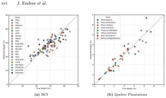
On BIRCH-Trees, DINOvTree—a fine-tuned DINOv3 backbone with separate cross-attention heads for height regression and species classification—achieves state-of-the-art or second-best height metrics and competitive classification while using only 54–58 percent of the parameters of the second-best approach. Learned methods substantially outperform traditional allometric equations even when those equations receive ground-truth species and masks; frozen foundation models fail, so fine-tuning is required.
What carries the argument
DINOvTree: a shared fine-tuned Vision Foundation Model (DINOv3) whose patch tokens feed two task-specific heads. Each head projects tokens with an MLP, then lets a learnable query cross-attend with 2-D positional encodings; the classification head also concatenates the backbone [CLS] token. The joint loss is Dynamic Weight Average of smooth-L1 height loss and cross-entropy species loss.
Load-bearing premise
Height ground truth is defined as the 99th-percentile LiDAR canopy-height value inside a buffered crown mask, and evaluation assumes clean tree-centered crops are already available; if that proxy is systematically wrong for thin, leaning, dead or occluded trees, both training targets and reported height scores collapse.
What would settle it
Independently re-measure height and species of a held-out subset of trees in the field, recompute all metrics against those field values instead of LiDAR-derived labels, and check whether DINOvTree still ranks first or second with the same parameter advantage.
If this is right
- Individual tree height can be regressed from a single centered RGB UAV tile without LiDAR at inference time.
- Sharing one foundation-model backbone across height and species cuts parameters nearly in half with little or no accuracy loss versus two separate models.
- Classical allometric height equations remain inferior to modern vision models even when given oracle species and crown geometry.
- Scaling the backbone from Base to Large improves most metrics across temperate, tropical and plantation forests.
- BIRCH-Trees becomes a concrete out-of-distribution testbed for future foundation models on high-resolution forest imagery.
Where Pith is reading between the lines
- If existing crown segmenters already reach human-level accuracy, DINOvTree can be chained into an end-to-end UAV biomass pipeline without new field campaigns for every stand.
- The observed overestimation of short trees and underestimation of tall ones points to residual scale bias that height-stratified sampling or size-aware losses might reduce.
- The same multi-task head pattern may transfer to other drone objects—buildings, crops—where geometric size and categorical identity must be predicted together.
- High variance on rare species suggests semi-supervised use of the abundant unlabeled canopy tiles the authors themselves flag as future work.
Editorial analysis
A structured set of objections, weighed in public.
Referee Report
Summary. The paper introduces BIRCH-Trees, a benchmark for joint individual-tree height regression and species classification from tree-centered RGB UAV images, built from three existing sources (Quebec Trees temperate forest, BCI tropical forest, Quebec Plantations boreal). Heights are derived from concurrent LiDAR CHMs via a buffered-mask 99th-percentile (or max) procedure (Eqs. 1–2, Sec. 3.1); species labels come from the source annotations. The authors propose DINOvTree, a multi-task model that fine-tunes a shared DINOv3 ViT backbone and attaches two cross-attention heads (height query + classification query concatenated with the [CLS] token), trained with smooth-L1 and cross-entropy under Dynamic Weight Average. Extensive multi-seed comparisons against allometric equations (oracle species/masks), Mask R-CNN height bins, CNNs, hierarchical ViTs, MambaVision, AnySat, PECore and single-task DINOv3 show DINOvTree achieving top or near-top height metrics and competitive classification while using 54–58% of the parameters of the second-best approach (Tables 1–3). Ablations cover head components, loss weighting, parameter sharing and backbone scale.
Significance. If the empirical results hold, the work supplies the first multi-biome, multi-task benchmark for individual-tree height and species from single-RGB UAV crops and a parameter-efficient multi-task VFM baseline that clearly beats classical allometrics and prior Mask R-CNN pipelines. The three-dataset design, multi-seed means±SE, and systematic ablations (heads, DWA vs UW/EW/PCGrad, sharing, Base→Large scaling) make the ranking claims reproducible and useful for forest-monitoring and biomass pipelines that already assume crown detection/segmentation. The explicit comparison to oracle allometrics and the public benchmark framing are concrete contributions beyond a pure methods paper.
major comments (2)
- Sec. 3.1 / Eqs. (1)–(2): Height labels are the 99th percentile (or max on plantations) of LiDAR CHM values inside a buffered crown mask. The paper itself notes that dead, thin, leaning or occluded crowns produce noisier targets (App. D.5, Fig. 17). Because every method is trained and scored against the same proxy, relative rankings remain valid, but absolute MAE/RMSE/δ1.25 should be interpreted as agreement with this proxy rather than field height. A short quantitative sensitivity study (e.g., P95 vs P99 vs max, or buffer 0.05L vs 0.1L) on at least one dataset would strengthen the claim that the reported height errors are not dominated by label construction.
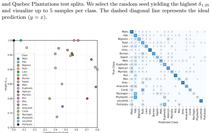
- Tables 1–3 and Sec. 5.2: Classification F1 on rare classes (e.g., Tsuga canadensis n=9 train, Betula alleghaniensis n=11 train, several BCI families <20) exhibits high seed-to-seed variance; the paper correctly flags this in the conclusion. Macro-F1 is therefore partly driven by a handful of low-count classes. Reporting per-class F1 with confidence intervals or a frequency-stratified metric (head/mid/tail) would make the “competitive classification” claim more transparent and would clarify whether DINOvTree’s multi-task design helps or hurts the tail.
minor comments (5)
- Abstract and Sec. 1: “first benchmark” is accurate for the joint height+species tree-centered RGB setting, but a brief footnote acknowledging prior single-task or multi-modal individual-tree datasets would avoid over-claiming absolute novelty.
- Fig. 3 / Eq. (1): The buffer definition uses Euclidean distance in pixel space; a one-sentence note that L is measured in pixels (not meters) would prevent unit confusion for readers coming from forestry.
- Sec. 5.1: Mask R-CNN is adapted by supervising only the center tree and selecting the nearest centroid at inference; this is reasonable but should be stated more prominently so that readers do not treat the numbers as a direct re-implementation of Hao/Fu.
- App. C: The linear height correction and negative-height exclusion for Quebec Plantations are important; a short main-text pointer would help readers who skip the appendix.
- Typos / consistency: “UA V” spacing in the title, occasional “in-domain” vs “in domain”, and mixed use of “δ1.25” vs “δ 1.25” should be normalized.
Circularity Check
No significant circularity: ordinary empirical multi-task VFM evaluation on a new benchmark with external LiDAR/field labels.
full rationale
The paper constructs BIRCH-Trees by extracting tree-centered RGB tiles and height labels from existing orthomosaics + concurrent LiDAR CHMs (buffered 99th-percentile, Eqs. 1-2) plus species annotations, then trains and evaluates DINOvTree (shared DINOv3 backbone + cross-attention heads, DWA loss weighting) against CNNs/ViTs/VFMs and allometric baselines on three held-out spatial splits. All reported metrics (MAE/RMSE/MSLE/δ1.25, macro-F1/Acc) and the parameter-efficiency claim are ordinary supervised-learning outcomes measured against those external labels; nothing is algebraically forced by a fitted constant, self-definition, or uniqueness theorem. Self-citations (e.g., to Teng et al. for splits/segmentations, Lefebvre et al. for plantations CHM correction) supply input data or prior engineering, not the claimed SOTA numbers. Ablations and multi-seed tables further confirm independent content. No pattern 1-6 applies.
Axiom & Free-Parameter Ledger
free parameters (6)
- CHM buffer factor (0.1L; 0.05L on plantations)
- Height aggregation percentile (P99; max on plantations)
- DWA temperature T=2 and early equal weights
- Learning rate schedule (peak 5e-5, backbone 0.5×, warmup/cosine)
- Mask R-CNN height bin width 0.2 m
- Smooth L1 transition threshold of 1 m
axioms (5)
- domain assumption LiDAR-derived CHM values inside a buffered crown mask are accurate enough individual-tree height labels for training and evaluation.
- domain assumption Tree-centered 512×512 crops from high-quality crown segmentations are a realistic evaluation setting for field deployment.
- domain assumption Web-pretrained DINOv3 features, after full fine-tuning, transfer to high-resolution UAV forest imagery for both geometric height and fine-grained species.
- domain assumption Spatial train/val/test splits from Teng et al. sufficiently control spatial autocorrelation.
- standard math Standard deep learning optimization (AdamW, cross-entropy, smooth L1) yields valid comparative rankings of architectures.
invented entities (2)
-
BIRCH-Trees benchmark
no independent evidence
-
DINOvTree multi-task architecture
no independent evidence
read the original abstract
Accurate estimation of forest biomass, a major carbon sink, relies heavily on tree-level traits such as height and species. Unoccupied Aerial Vehicles (UAVs) capturing high-resolution imagery from a single RGB camera offer a cost-effective and scalable approach for mapping and measuring individual trees. We introduce BIRCH-Trees, the first benchmark for individual tree height and species estimation from tree-centered UAV images, spanning three datasets: temperate forests, tropical forests, and boreal plantations. We also present DINOvTree, a unified approach using a Vision Foundation Model (VFM) backbone with task-specific heads for simultaneous height and species prediction. Through extensive evaluations on BIRCH-Trees, we compare DINOvTree against commonly used vision methods, including VFMs, as well as biological allometric equations. We find that DINOvTree achieves top overall results with accurate height predictions and competitive classification accuracy while using only 54% to 58% of the parameters of the second-best approach.
Figures



Reference graph
Works this paper leans on
-
[1]
In: CVPR
Astruc, G., Gonthier, N., Mallet, C., Landrieu, L.: AnySat: One earth observation model for many resolutions, scales, and modalities. In: CVPR. pp. 19530–19540 (2025)
2025
-
[2]
arXiv:1607.06450 [stat.ML] (2016)
Ba, J.L., Kiros, J.R., Hinton, G.E.: Layer normalization. arXiv:1607.06450 [stat.ML] (2016)
Pith/arXiv arXiv 2016
-
[3]
Bastani, F., Wolters, P., Gupta, R., Ferdinando, J., Kembhavi, A.: Satlaspretrain: Alarge-scaledatasetforremotesensingimageunderstanding.In:ICCV.pp.16772– 16782 (2023)
2023
-
[4]
Baudchon, H.: GeoDataset (2024),https : / / hugobaudchon . github . io / geodataset/
2024
-
[5]
In: ICLR (2026)
Baudchon, H., Ouaknine, A., Weiss, M., Teng, M., Walla, T.R., Caron-Guay, A., Pal, C., Laliberté, E.: SelvaBox: A high-resolution dataset for tropical tree crown detection. In: ICLR (2026)
2026
-
[6]
Remote Sensing15(5), 1463 (2023)
Beloiu, M., Heinzmann, L., Rehush, N., Gessler, A., Griess, V.C.: Individual tree- crown detection and species identification in heterogeneous forests using aerial rgb imagery and deep learning. Remote Sensing15(5), 1463 (2023)
2023
-
[7]
In: NeurIPS (2025)
Bolya, D., Huang, P.Y., Sun, P., Cho, J.H., Madotto, A., Wei, C., Ma, T., Zhi, J., Rajasegaran, J., Rasheed, H., et al.: Perception encoder: The best visual embed- dings are not at the output of the network. In: NeurIPS (2025)
2025
-
[8]
New Forests51(4), 573–596 (2020)
Camarretta, N., Harrison, P.A., Bailey, T., Potts, B., Lucieer, A., Davidson, N., Hunt, M.: Monitoring forest structure to guide adaptive management of forest restoration: a review of remote sensing approaches. New Forests51(4), 573–596 (2020)
2020
-
[9]
In: ECCV
Carion, N., Massa, F., Synnaeve, G., Usunier, N., Kirillov, A., Zagoruyko, S.: End- to-end object detection with transformers. In: ECCV. pp. 213–229 (2020)
2020
-
[10]
IEEE Geoscience and Remote Sensing Letters17(8), 1391–1395 (2019)
Carvalho, M., Le Saux, B., Trouvé-Peloux, P., Champagnat, F., Almansa, A.: Mul- titask learning of height and semantics from aerial images. IEEE Geoscience and Remote Sensing Letters17(8), 1391–1395 (2019)
2019
-
[11]
Remote Sensing of Environment311, 114283 (2024)
Cloutier, M., Germain, M., Laliberté, E.: Influence of temperate forest autumn leaf phenology on segmentation of tree species from uav imagery using deep learning. Remote Sensing of Environment311, 114283 (2024)
2024
-
[12]
In: CVPR
Cui, Y., Jia, M., Lin, T.Y., Song, Y., Belongie, S.: Class-balanced loss based on effective number of samples. In: CVPR. pp. 9268–9277 (2019)
2019
-
[13]
Bi- ological Conservation253, 108907 (2021) 16 J
Davies, S.J., Abiem, I., Salim, K.A., Aguilar, S., Allen, D., Alonso, A., Anderson- Teixeira, K., Andrade, A., Arellano, G., Ashton, P.S., et al.: ForestGEO: Under- standing forest diversity and dynamics through a global observatory network. Bi- ological Conservation253, 108907 (2021) 16 J. Endreset al
2021
-
[14]
In: CVPR
Deng, J., Dong, W., Socher, R., Li, L.J., Li, K., Fei-Fei, L.: Imagenet: A large-scale hierarchical image database. In: CVPR. pp. 248–255 (2009)
2009
-
[15]
In: ICLR (2020)
Dosovitskiy, A., Beyer, L., Kolesnikov, A., Weissenborn, D., Zhai, X., Unterthiner, T., Dehghani, M., Minderer, M., Heigold, G., Gelly, S., et al.: An image is worth 16x16 words: Transformers for image recognition at scale. In: ICLR (2020)
2020
-
[16]
arXiv:2602.02426 [cs.CV] (2026)
Duguay, S.O., Baudchon, H., Laliberté, E., Muller-Landau, H., Rivas-Torres, G., Ouaknine, A.: SelvaMask: Segmenting trees in tropical forests and beyond. arXiv:2602.02426 [cs.CV] (2026)
arXiv 2026
-
[17]
Computers and Electronics in Agriculture219, 108785 (2024)
Ecke, S., Stehr, F., Frey, J., Tiede, D., Dempewolf, J., Klemmt, H.J., Endres, E., Seifert, T.: Towards operational uav-based forest health monitoring: Species iden- tification and crown condition assessment by means of deep learning. Computers and Electronics in Agriculture219, 108785 (2024)
2024
-
[18]
Remote Sensing12(23), 3892 (2020)
Egli, S., Höpke, M.: Cnn-based tree species classification using high resolution rgb image data from automated uav observations. Remote Sensing12(23), 3892 (2020)
2020
-
[19]
In: NeurIPS (2014)
Eigen, D., Puhrsch, C., Fergus, R.: Depth map prediction from a single image using a multi-scale deep network. In: NeurIPS (2014)
2014
-
[20]
FAO, Rome, Italy (2025).https: //doi.org/10.4060/cd6709en
FAO: Global Forest Resources Assessment 2025. FAO, Rome, Italy (2025).https: //doi.org/10.4060/cd6709en
doi:10.4060/cd6709en 2025
-
[21]
https://doi.org/10.60635/C3F593
ForestGEO Smithsonian: 2023 high-resolution airborne LiDAR data for Barro Col- orado Island and other Smithsonian ForestGEO Sites in Central Panama (2024). https://doi.org/10.60635/C3F593
-
[22]
Forest Ecology and Management555, 121712 (2024)
Fu, H., Zhao, H., Jiang, J., Zhang, Y., Liu, G., Xiao, W., Du, S., Guo, W., Liu, X.: Automatic detection tree crown and height using mask r-cnn based on unmanned aerial vehicles images for biomass mapping. Forest Ecology and Management555, 121712 (2024)
2024
-
[23]
IEEE Transactions on Geoscience and Remote Sensing61, 1–15 (2023)
Gao,Z.,Sun,W.,Lu,Y.,Zhang,Y.,Song,W.,Zhang,Y.,Zhai,R.:Jointlearningof semantic segmentation and height estimation for remote sensing image leveraging contrastive learning. IEEE Transactions on Geoscience and Remote Sensing61, 1–15 (2023)
2023
-
[24]
In: ICCV
Girshick, R.: Fast r-cnn. In: ICCV. pp. 1440–1448 (2015)
2015
-
[25]
In: First conference on language modeling (2024)
Gu, A., Dao, T.: Mamba: Linear-time sequence modeling with selective state spaces. In: First conference on language modeling (2024)
2024
-
[26]
In: NeurIPS (2025)
Gu, J., Stevens, S., Campolongo, E.G., Thompson, M.J., Zhang, N., Wu, J., Kopanev, A., Mai, Z., White, A.E., Balhoff, J., Dahdul, W., Rubenstein, D., Lapp, H., Berger-Wolf, T., Chao, W.L., Su, Y.: BioCLIP 2: Emergent properties from scaling hierarchical contrastive learning. In: NeurIPS (2025)
2025
-
[27]
ISPRS Journal of Photogrammetry and Remote Sensing178, 112–123 (2021)
Hao, Z., Lin, L., Post, C.J., Mikhailova, E.A., Li, M., Chen, Y., Yu, K., Liu, J.: Automated tree-crown and height detection in a young forest plantation using mask region-based convolutional neural network (mask r-cnn). ISPRS Journal of Photogrammetry and Remote Sensing178, 112–123 (2021)
2021
-
[28]
In: CVPR
Hatamizadeh, A., Kautz, J.: Mambavision: A hybrid mamba-transformer vision backbone. In: CVPR. pp. 25261–25270 (2025)
2025
-
[29]
In: ICCV
He, K., Gkioxari, G., Dollár, P., Girshick, R.: Mask r-cnn. In: ICCV. pp. 2961–2969 (2017)
2017
-
[30]
In: CVPR
He, K., Zhang, X., Ren, S., Sun, J.: Deep residual learning for image recognition. In: CVPR. pp. 770–778 (2016)
2016
-
[31]
arXiv:1606.08415 [cs.LG] (2016)
Hendrycks, D.: Gaussian error linear units (gelus). arXiv:1606.08415 [cs.LG] (2016)
Pith/arXiv arXiv 2016
-
[32]
Global change biology 28(17), 5254–5268 (2022) Estimating Individual Tree Height and Species from UAV Imagery 17
Jucker, T., Fischer, F.J., Chave, J., Coomes, D.A., Caspersen, J., Ali, A., Loub- ota Panzou, G.J., Feldpausch, T.R., Falster, D., Usoltsev, V.A., et al.: Tallo: A global tree allometry and crown architecture database. Global change biology 28(17), 5254–5268 (2022) Estimating Individual Tree Height and Species from UAV Imagery 17
2022
-
[33]
In: CVPR
Kendall, A., Gal, Y., Cipolla, R.: Multi-task learning using uncertainty to weigh losses for scene geometry and semantics. In: CVPR. pp. 7482–7491 (2018)
2018
-
[34]
In: NeurIPS (2012)
Krizhevsky, A., Sutskever, I., Hinton, G.E.: Imagenet classification with deep con- volutional neural networks. In: NeurIPS (2012)
2012
-
[35]
bioRxiv (2025).https://doi.org/10.1101/2025.09.02.673753
Laliberté, E., Caron-Guay, A., Le Falher, V., Tougas, G., Muller-Landau, H.C., Rivas-Torres, G., Walla, T.R., Baudchon, H., Hernandez, M., Buenaño, A., Weber, A., Chambers, J.Q., Inuma, J.C., Araúz, F., Valdes, J., Hernández, A., Brassfield, D., Sérgio, P., Vasquez, V., Simonetti, A., Marra, D.M., Vasconcelos, C., Vaca, J.F., Rivadeneyra, G., Illanes, J.,...
-
[36]
Nature Ecology & Evolution7(11), 1778–1789 (2023)
Lang, N., Jetz, W., Schindler, K., Wegner, J.D.: A high-resolution canopy height model of the earth. Nature Ecology & Evolution7(11), 1778–1789 (2023)
2023
-
[37]
Remote Sensing of Environment233, 111347 (2019)
Lang, N., Schindler, K., Wegner, J.D.: Country-wide high-resolution vegetation height mapping with sentinel-2. Remote Sensing of Environment233, 111347 (2019)
2019
-
[38]
Lefebvre, I.: Suivi de la séquestration de CO2 aérien dans des sites en reforestation à l’aide de drones. Mémoire de maîtrise, Université de Montréal, Montréal, Québec (Jul 2025).https://doi.org/10.71781/20561
-
[39]
https://doi.org/10.20383/103.0979
Lefebvre, I., Laliberté, E.: Uav lidar, uav imagery, tree segmentations and ground measurements for estimating tree biomass in canadian (quebec) plantations (2024). https://doi.org/10.20383/103.0979
-
[40]
Lefort, T., Affouard, A., Charlier, B., Lombardo, J.C., Chouet, M., Goëau, H., Salmon, J., Bonnet, P., Joly, A.: Cooperative learning of pl@ ntnet’s artificial intelligence algorithm: How does it work and how can we improve it? Methods in Ecology and Evolution (2024)
2024
-
[41]
PNAS nexus2(2023)
Li, S., Brandt, M., Fensholt, R., Kariryaa, A., Igel, C., Gieseke, F., Nord-Larsen, T., Oehmcke, S., Carlsen, A.H., Junttila, S., et al.: Deep learning enables image- based tree counting, crown segmentation, and height prediction at national scale. PNAS nexus2(2023)
2023
-
[42]
Remote Sensing 14(13), 3035 (2022)
Li, Y., Chai, G., Wang, Y., Lei, L., Zhang, X.: ACE R-CNN: An attention comple- mentary and edge detection-based instance segmentation algorithm for individual tree species identification using uav rgb images and lidar data. Remote Sensing 14(13), 3035 (2022)
2022
-
[43]
Drones 9(4), 296 (2025)
Li, Z., Yu, S., Ye, Q., Zhang, M., Yin, D., Zhao, Z.: Tree species classification using uav-based rgb images and spectral information on the loess plateau, china. Drones 9(4), 296 (2025)
2025
-
[44]
In: ICCV
Lin, T.Y., Goyal, P., Girshick, R., He, K., Dollár, P.: Focal loss for dense object detection. In: ICCV. pp. 2980–2988 (2017)
2017
-
[45]
In: CVPR
Liu, S., Johns, E., Davison, A.J.: End-to-end multi-task learning with attention. In: CVPR. pp. 1871–1880 (2019)
2019
-
[46]
In: NeurIPS
Liu, Y., Tian, Y., Zhao, Y., Yu, H., Xie, L., Wang, Y., Ye, Q., Jiao, J., Liu, Y.: Vmamba: Visual state space model. In: NeurIPS. pp. 103031–103063 (2024)
2024
-
[47]
In: CVPR
Liu,Z.,Hu,H.,Lin,Y.,Yao,Z.,Xie,Z.,Wei,Y.,Ning,J.,Cao,Y.,Zhang,Z.,Dong, L., et al.: Swin transformer v2: Scaling up capacity and resolution. In: CVPR. pp. 12009–12019 (2022)
2022
-
[48]
In: CVPR
Liu, Z., Mao, H., Wu, C.Y., Feichtenhofer, C., Darrell, T., Xie, S.: A convnet for the 2020s. In: CVPR. pp. 11976–11986 (2022)
2022
-
[49]
In: ICLR (2017) 18 J
Loshchilov, I., Hutter, F.: SGDR: Stochastic gradient descent with warm restarts. In: ICLR (2017) 18 J. Endreset al
2017
-
[50]
In: ICLR (2019)
Loshchilov, I., Hutter, F.: Decoupled weight decay regularization. In: ICLR (2019)
2019
-
[51]
In: ICML
Nair, V., Hinton, G.E.: Rectified linear units improve restricted boltzmann ma- chines. In: ICML. pp. 807–814 (2010)
2010
-
[52]
The International Archives of the Photogrammetry, Remote Sensing and Spatial Information Sciences42, 475–481 (2019)
Natesan, S., Armenakis, C., Vepakomma, U.: Resnet-based tree species classifica- tion using uav images. The International Archives of the Photogrammetry, Remote Sensing and Spatial Information Sciences42, 475–481 (2019)
2019
-
[53]
Journal of Unmanned Vehicle Systems8(4), 310–333 (2020)
Natesan, S., Armenakis, C., Vepakomma, U.: Individual tree species identification using dense convolutional network (densenet) on multitemporal rgb images from uav. Journal of Unmanned Vehicle Systems8(4), 310–333 (2020)
2020
-
[54]
Remote Sensing12(7), 1070 (2020)
Nezami, S., Khoramshahi, E., Nevalainen, O., Pölönen, I., Honkavaara, E.: Tree species classification of drone hyperspectral and rgb imagery with deep learning convolutional neural networks. Remote Sensing12(7), 1070 (2020)
2020
-
[55]
TMLR (2024)
Oquab, M., Darcet, T., Moutakanni, T., Vo, H., Szafraniec, M., Khalidov, V., Fernandez, P., Haziza, D., Massa, F., El-Nouby, A., et al.: Dinov2: Learning robust visual features without supervision. TMLR (2024)
2024
-
[56]
Science333(6045), 988–993 (2011)
Pan, Y., Birdsey, R.A., Fang, J., Houghton, R., Kauppi, P.E., Kurz, W.A., Phillips, O.L., Shvidenko, A., Lewis, S.L., Canadell, J.G., Ciais, P., Jackson, R.B., Pacala, S.W., McGuire, A.D., Piao, S., Rautiainen, A., Sitch, S., Hayes, D.: A large and persistent carbon sink in the world’s forests. Science333(6045), 988–993 (2011). https://doi.org/10.1126/sci...
-
[57]
Advances in neural information processing sys- tems32(2019)
Paszke, A., Gross, S., Massa, F., Lerer, A., Bradbury, J., Chanan, G., Killeen, T., Lin, Z., Gimelshein, N., Antiga, L., et al.: PyTorch: An imperative style, high- performance deep learning library. Advances in neural information processing sys- tems32(2019)
2019
-
[58]
In: ICML
Pauls, J., Zimmer, M., Kelly, U.M., Schwartz, M., Saatchi, S., Ciais, P., Pokutta, S., Brandt, M., Gieseke, F.: Estimating canopy height at scale. In: ICML. pp. 39972–39988 (2024)
2024
-
[59]
In: ICML (2025)
Pauls, J., Zimmer, M., Turan, B., Saatchi, S., Ciais, P., Pokutta, S., Gieseke, F.: Capturing temporal dynamics in large-scale canopy tree height estimation. In: ICML (2025)
2025
-
[60]
Plants 12(21), 3710 (2023)
Phillips, O.L.: Sensing forests directly: The power of permanent plots. Plants 12(21), 3710 (2023)
2023
-
[61]
ISPRS Annals of the Photogram- metry, Remote Sensing and Spatial Information Sciences10, 1089–1096 (2023)
Pierdicca, R., Nepi, L., Mancini, A., Malinverni, E., Balestra, M.: Uav4tree: Deep learning-based system for automatic classification of tree species using rgb optical images obtained by an unmanned aerial vehicle. ISPRS Annals of the Photogram- metry, Remote Sensing and Spatial Information Sciences10, 1089–1096 (2023)
2023
-
[62]
Remote Sensing of Environment280, 113143 (2022)
Qin, H., Zhou, W., Yao, Y., Wang, W.: Individual tree segmentation and tree species classification in subtropical broadleaf forests using uav-based lidar, hyper- spectral, and ultrahigh-resolution rgb data. Remote Sensing of Environment280, 113143 (2022)
2022
-
[63]
Computers and Electronics in Agriculture240, 111162 (2026)
Que, H., Gao, H., Shan, W., Liu, M., An, J., Deng, F., Feng, S., Yang, X., Mu, L.: FM-SAM: individual tree crown delineation and classification based on segmen- tation anything model (sam) and yolov10 in uav imagery for forest monitoring. Computers and Electronics in Agriculture240, 111162 (2026)
2026
-
[64]
Environmental Data Science4, e37 (2025).https://doi.org/ 10.1017/eds.2025.10013
Ramesh, V., Ouaknine, A., Rolnick, D.: Tree semantic segmentation from aerial image time series. Environmental Data Science4, e37 (2025).https://doi.org/ 10.1017/eds.2025.10013
-
[65]
In: International Conference on Medical image computing and computer-assisted intervention
Ronneberger, O., Fischer, P., Brox, T.: U-net: Convolutional networks for biomedi- cal image segmentation. In: International Conference on Medical image computing and computer-assisted intervention. pp. 234–241 (2015) Estimating Individual Tree Height and Species from UAV Imagery 19
2015
-
[66]
ISPRS Journal of Photogrammetry and Remote Sensing170, 205–215 (2020)
Schiefer, F., Kattenborn, T., Frick, A., Frey, J., Schall, P., Koch, B., Schmidtlein, S.: Mapping forest tree species in high resolution uav-based rgb-imagery by means of convolutional neural networks. ISPRS Journal of Photogrammetry and Remote Sensing170, 205–215 (2020)
2020
-
[67]
IEEE Transactions on Geo- science and Remote Sensing (2025)
Shen, Y., Xiao, L., Chen, J., Du, Q., Ye, Q.: Learning cross-task features with mamba for remote sensing image multi-task prediction. IEEE Transactions on Geo- science and Remote Sensing (2025)
2025
-
[68]
arXiv:2508.10104 [cs.CV] (2025)
Siméoni, O., Vo, H.V., Seitzer, M., Baldassarre, F., Oquab, M., Jose, C., Khalidov, V., Szafraniec, M., Yi, S., Ramamonjisoa, M., Massa, F., Haziza, D., Wehrstedt, L., Wang, J., Darcet, T., Moutakanni, T., Sentana, L., Roberts, C., Vedaldi, A., Tolan, J., Brandt, J., Couprie, C., Mairal, J., Jégou, H., Labatut, P., Bojanowski, P.: DINOv3. arXiv:2508.10104...
Pith/arXiv arXiv 2025
-
[69]
In: 2017 IEEE International Geoscience and Remote Sensing Symposium (IGARSS)
Srivastava, S., Volpi, M., Tuia, D.: Joint height estimation and semantic labeling of monocular aerial images with cnns. In: 2017 IEEE International Geoscience and Remote Sensing Symposium (IGARSS). pp. 5173–5176 (2017)
2017
-
[70]
In: CVPR
Stevens, S., Wu, J., Thompson, M.J., Campolongo, E.G., Song, C.H., Carlyn, D.E., Dong, L., Dahdul, W.M., Stewart, C., Berger-Wolf, T., et al.: BioCLIP: A vision foundation model for the tree of life. In: CVPR. pp. 19412–19424 (2024)
2024
-
[71]
Forests10(11), 1047 (2019)
Sun, Y., Huang, J., Ao, Z., Lao, D., Xin, Q.: Deep learning approaches for the mapping of tree species diversity in a tropical wetland using airborne lidar and high-spatial-resolution remote sensing images. Forests10(11), 1047 (2019)
2019
-
[72]
In: NeurIPS (2025)
Teng, M., Ouaknine, A., Laliberté, E., Bengio, Y., Rolnick, D., Larochelle, H.: Bringing SAM to new heights: Leveraging elevation data for tree crown segmenta- tion from drone imagery. In: NeurIPS (2025)
2025
-
[73]
Remote Sensing of Environment300, 113888 (2024)
Tolan,J.,Yang,H.I.,Nosarzewski,B.,Couairon,G.,Vo,H.V.,Brandt,J.,Spore,J., Majumdar, S., Haziza, D., Vamaraju, J., et al.: Very high resolution canopy height maps from rgb imagery using self-supervised vision transformer and convolutional decoder trained on aerial lidar. Remote Sensing of Environment300, 113888 (2024)
2024
-
[74]
arXiv:2502.14786 [cs.CV] (2025)
Tschannen, M., Gritsenko, A., Wang, X., Naeem, M.F., Alabdulmohsin, I., Parthasarathy, N., Evans, T., Beyer, L., Xia, Y., Mustafa, B., Hénaff, O., Harmsen, J., Steiner, A., Zhai, X.: SigLIP 2: Multilingual vision-language encoders with im- proved semantic understanding, localization, and dense features. arXiv:2502.14786 [cs.CV] (2025)
Pith/arXiv arXiv 2025
-
[75]
In: ICML (2025)
Tseng, G., Fuller, A., Reil, M., Herzog, H., Beukema, P., Bastani, F., Green, J.R., Shelhamer, E., Kerner, H., Rolnick, D.: Galileo: Learning global & local features of many remote sensing modalities. In: ICML (2025)
2025
-
[76]
Vasquez,V.,Cushman,K.,Ramos,P.,Williamson,C.,Villareal,P.,Correa,L.F.G., Muller-Landau, H.C.: Barro colorado island 50-ha plot crown maps: Manually segmented and instance segmented (2023).https://doi.org/10.25573/data. 24784053.v2
-
[77]
In: NeurIPS (2017)
Vaswani,A.,Shazeer,N.,Parmar,N.,Uszkoreit,J.,Jones,L.,Gomez,A.N.,Kaiser, Ł., Polosukhin, I.: Attention is all you need. In: NeurIPS (2017)
2017
-
[78]
Remote Sensing of Environment305, 114099 (2024)
Wagner, F.H., Roberts, S., Ritz, A.L., Carter, G., Dalagnol, R., Favrichon, S., Hirye, M.C., Brandt, M., Ciais, P., Saatchi, S.: Sub-meter tree height mapping of california using aerial images and lidar-informed u-net model. Remote Sensing of Environment305, 114099 (2024)
2024
-
[79]
Wagner, F.H., Dalagnol, R., Carter, G., Hirye, M.C.M., Gill, S., Le, S.B.T., Favri- chon, S., Keller, M., Ometto, J.P.H.B., Alves, L., Creze, C., George-Chacón, S.P., Li, S., Liu, Z., Mullissa, A.G., Yang, Y., dos Santos, E.G., Worden, S.R., 20 J. Endreset al. Brandt, M., Ciais, P., Hagen, S.C., Saatchi, S.: High resolution tree height map- ping of the am...
Pith/arXiv arXiv 2025
-
[80]
IEEE Journal of Selected Topics in Applied Earth Observations and Remote Sensing17, 11632–11654 (2024)
Wang, D., Zhang, J., Xu, M., Liu, L., Wang, D., Gao, E., Han, C., Guo, H., Du, B., Tao, D., et al.: Mtp: Advancing remote sensing foundation model via multitask pretraining. IEEE Journal of Selected Topics in Applied Earth Observations and Remote Sensing17, 11632–11654 (2024)
2024
discussion (0)
Sign in with ORCID, Apple, or X to comment. Anyone can read and Pith papers without signing in.