REVIEW 5 major objections 4 minor 24 references
Cooperative indoor drone guidance can be built on a shared voxel map that each drone reads as an ego-aligned bird's-eye view, and a multi-agent learned controller using this substrate outperforms classical planners in simulation and transfe
Reviewed by Pith at T0; open to challenge. T0 means a machine referee read the full paper against a public rubric. the ladder, T0–T4 →
T0 review · deepseek-v4-flash
2026-08-01 01:37 UTC pith:YF5HW66B
load-bearing objection Genuine system-integration paper with a real two-UAV hardware demo, but the experiments never isolate the shared-map contribution that the title promises. the 5 major comments →
Shared Voxel-Map-Based Cooperative Indoor UAV Guidance with a Multi-Agent Soft Actor-Critic Controller
The pith
A machine-rendered reading of the paper's core claim, the machinery that carries it, and where it could break.
Core claim
On the paper's own terms, the discovery is that 'integrate-in-world, act-in-ego' — fusing all LiDAR into one world-frame 3D occupancy grid, then projecting a vertical slice into a two-channel BEV tensor (occupancy + clipped Euclidean clearance) and feeding each agent a 39x39 ego-aligned crop plus a compact goal-and-peer vector — yields a cooperative controller that generalizes across corridor layouts and hardware. The authors show this with a centralised-training, decentralised-execution MASAC policy: during training the actor's latent features and joint actions support twin critics, while at execution each drone uses only its own crop and onboard features. They further show that simulation-
What carries the argument
The central object is the shared world-frame voxel occupancy map (0.25 m cells), updated by ray-carving free space and incrementing hit cells from 360-degree LiDAR, then collapsed into a two-channel bird's-eye-view tensor (binary occupancy and a clipped Euclidean-distance-transform clearance channel). Each agent consumes a 39x39-cell (9.75 m) ego-aligned crop plus a five-dimensional goal-and-peer vector, keeping policy input size independent of team size. The control side is a Multi-Agent Soft Actor-Critic (MASAC) policy: a multi-branch actor with convolutional encoders for angular depth bands and the BEV crop and an MLP for the vector, outputting a Gaussian action head (forward velocity, ya
Load-bearing premise
The framework's gain rests entirely on the two drones' poses being accurate and synchronized enough to fuse into one world frame; the paper reports that lidar-inertial odometry provided a consistent reference, but gives no drift bound or sensitivity analysis, so relative pose error approaching the 0.25 m voxel size would misalign the ego-aligned crops and erase the cooperative advantage.
What would settle it
Re-run the real-world two-drone missions while injecting controlled relative-pose offsets (or artificially delaying map updates) and measure joint success; if success remains near 100% with offsets beyond the 0.25 m map resolution, the shared-frame premise is not load-bearing. Alternatively, ablate the shared map by feeding each drone only its own local occupancy crop and compare the success rate to the 90.3% reported; a drop toward the single-drone baseline would confirm the central claim.
If this is right
- If the central claim holds, shared-voxel-map BEV input becomes a viable interface for learned multi-robot control in cluttered, GNSS-denied indoor spaces, and the approach extends naturally to any team size since policy inputs stay fixed.
- The 50/50 real-world result with two drones implies that offline imitation fine-tuning from a classical reference controller is a reliable sim-to-real bridge for cooperative learned navigation, at least at this scale.
- The large gap between the learned controller and the A*/APF baselines under noisy, delayed, peer-obstructed map updates suggests that end-to-end control on fused geometry is materially safer and more adaptive than planning or reactive methods in this regime.
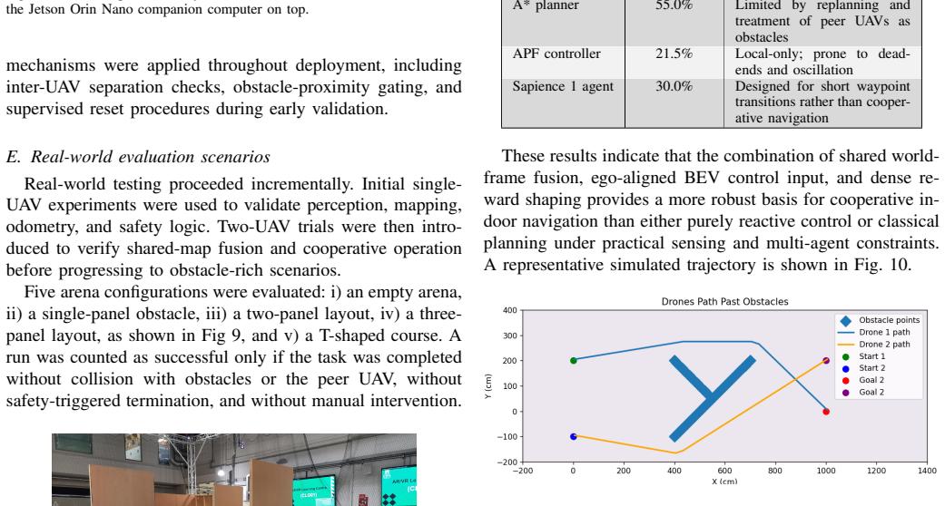
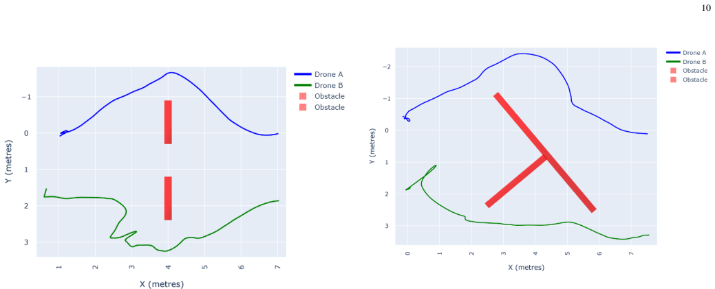
- The paper's own trajectory evidence (e.g., one drone yielding at a narrow passage, two drones choosing opposite routes around a T-junction) indicates the controller learns implicit coordination from the shared map and separation rewards, without explicit sequencing.
Where Pith is reading between the lines
- Beyond the paper: if the shared map is what carries the cooperative advantage, then inter-drone pose error above the voxel resolution (0.25 m) should degrade success; a direct sensitivity experiment varying relative localisation error would put the 'shared-frame substrate' claim under pressure.
- Beyond the paper: the planar, fixed-size BEV crop suggests the same architecture could apply to ground robots or mixed ground-air teams with minimal modification, but the paper does not test this.
- Beyond the paper: because the offline imitation stage used a single reference controller (A*), the fine-tuning may encode quirks of that planner; replacing behaviour cloning with an online residual or preference-based correction could decouple deployment from the planner's failure modes.
Editorial analysis
A structured set of objections, weighed in public.
Referee Report
Summary. The paper proposes a cooperative indoor UAV guidance framework in which multiple drones fuse 360° LiDAR into a shared world-frame voxel occupancy map, project it into a bird's-eye-view (BEV) representation with occupancy and clearance channels, and control each agent with a multi-agent Soft Actor-Critic (MASAC) policy. Training uses centralized critics and decentralized actors, with expert action blending (Eq. 6) and a dense reward (Eq. 4). In simulation, the policy is reported to achieve 90.3% success in two-UAV corridor navigation, versus 55.0% for A*, 21.5% for APF, and 30.0% for Sapience 1 (Table I). The policy was then fine-tuned by behavior cloning from an A* reference controller (Eq. 7) and deployed on two physical UAVs in a GNSS-denied indoor arena, with 100% success across 10 trials per course in five layouts (Table II). The abstract and Section V conclude that shared voxel-map representations provide an effective and scalable spatial substrate for learned cooperative indoor UAV guidance.
Significance. If the reported results hold, the paper makes a useful engineering contribution: it demonstrates a full autonomy stack for two-UAV cooperative indoor flight and shows that a world-frame voxel map with ego-aligned BEV crops can be integrated with a CTDE MASAC controller. The real-world deployment, including candid discussion of safety gating, map-fusion defects, and the need for imitation fine-tuning, is valuable and rare in the multi-UAV RL literature. However, the central scientific claim about the shared-map contribution is not supported by the presented comparisons, because no ablation isolates the sharing mechanism and the A* algorithm serves simultaneously as the strongest baseline and as the teacher for the real-world policy. The paper reports no code, data, or seeds, and the quantitative results lack statistical detail. The strengths are the concrete system design and honest limitations; the weakness is that the evidence underdetermines the claimed source of the performance gain.
major comments (5)
- [IV-A and II-D] The central claim that shared voxel-map representations are effective and scalable is underdetermined by the reported comparisons. Table I compares the full MASAC system against A*, APF, and Sapience, but there is no ablation in which the policy receives only ego-local map data or no peer state. Since Eq. (6) blends actions with an A*/APF expert during training and Eq. (7) fine-tunes the real-world policy by behavior cloning from A*, the 90.3% simulation and 100% hardware success could be driven by the BEV representation, dense reward shaping (Eq. 4), expert bootstrapping, or MASAC itself, without the shared-map fusion contributing. An ablation isolating the sharing mechanism is required to support the abstract and Section V claims.
- [III-B and III-C] Checkpoint selection is explicitly based on success: policies must achieve 100% on the training corridors before being shortlisted (Sec III-B), and the simulation evaluation trial count is unspecified ('a fixed number of trials', Sec III-C). No variance, confidence intervals, or seeds are reported for the 90.3% figure. This makes it impossible to assess whether the margin over A* (55.0%) is significant, especially given the selection procedure. Please report the number of trials, random seeds, and per-method variance, and consider a held-out selection criterion not based on the success metric.
- [II-F and IV-B] The real-world 100% success was obtained after offline imitation fine-tuning using actions from the same A* controller that is the weakest simulation baseline, and the deployed system operated under conservative safety gating (Sec II-E). Therefore the hardware result does not isolate the learned cooperative policy: the A* teacher may be providing most of the competence, and the safety layers may be preventing failures that the policy alone would incur. The paper should disclose the number of safety-gate interventions during the 50 trials and, ideally, evaluate the policy without the A*-labeled fine-tuning or with the safety layers disabled (where safe to do so) to support the claim.
- [II-E and IV-D] The collaborative benefit depends on accurate multi-vehicle registration: DLIO pose estimates must be sufficiently accurate and synchronized to fuse both lidar streams into a single world-frame map. Section II-E only states that DLIO 'provided a consistent local reference frame,' while Section IV-D lists localisation drift as a future limitation. The 5 Hz map update rate and the early occupancy-saturation defect further complicate the picture. Without a drift bound, latency analysis, or sensitivity study (e.g., deliberately perturbing relative pose), the claimed cooperative advantage could vanish if the shared frame degrades. A robustness analysis with respect to registration error is needed.
- [II-C and V] The scalability claim ('scalable spatial substrate', abstract) is supported only by the fixed input dimensionality, with no experiments for N>2 or communication-bandwidth analysis. Section IV-D acknowledges the study is limited to two UAVs. To support scalability, the paper should at least demonstrate the architecture in a three- or four-agent simulation and discuss the communication cost of sharing map updates under the 5 Hz constraint.
minor comments (4)
- [Eq. (2) and Eq. (5)] The definition of d_peer in Eq. (2) and the separation penalty in Eq. (5) are not clearly related: is d_peer the Euclidean distance or planar distance? Clarify.
- [II-A] The text says 'three elevation bands ... where appropriate as shown in Fig 1', but Fig 1 appears to show inverse depth bands; the text does not explain how these bands are computed or used in the policy input. Provide a brief description.
- [Table I] Table I reports success rates without trial counts; state the number of evaluation episodes for each method.
- [Throughout] The paper uses 'UA V' throughout, which appears to be a spacing artifact; should be 'UAV'.
Circularity Check
No circular derivation: the paper is an empirical systems study; the shared-map claim is underdetermined by missing ablations but not reducible to its inputs by construction.
full rationale
This paper is an empirical systems paper rather than an analytic derivation, so there is no formal derivation chain whose conclusions are equivalent to its inputs by construction. The main methodological overlap is that the policy is trained with expert action blending from A*/APF (Eq. 6) and later fine-tuned by behavior cloning from an A* teacher (Eq. 7), while A* is also a comparison baseline; however, the simulation success is evaluated using policy-only checkpoints and the policy still outperforms the A* teacher (90.3% vs 55.0%), so the comparison is not statistically forced. The real-world 100% success is reported for the integrated system after A*-labeled fine-tuning, but the paper explicitly attributes successful deployment also to localisation, communication, map fusion, and safety gating, and it lists localisation drift and map update latency as limitations. The absence of an ablation that isolates the shared-map component makes the central claim underdetermined experimentally, but that is a completeness/validity concern, not circularity: no parameter, equation, or fitted quantity is defined in terms of the claimed conclusion. The self-citations [22], [23] are contextual extensions of prior work and are not load-bearing, and the external DLIO odometry [24] is an independently published method. Accordingly, no specific circular step can be exhibited, and the honest finding is no significant circularity.
Axiom & Free-Parameter Ledger
free parameters (5)
- Reward shaping weights (w_xy, w_z, w_h, w_c, w_t, w_s, w_v, w_near_vz, w_wrong_vz, w_sep) and safety radii (d_safe, sigm =
Not reported
- SAC hyperparameters (entropy temperature alpha, discount gamma, Polyak tau, learning rates, batch size, actor delay, gra =
Not reported
- Expert-action blend coefficient beta schedule =
Annealed from 0 to 1
- Offline imitation fine-tuning settings (learning rate, number of steps, early-stopping checkpoint) =
Not reported; 'best-performing fine-tuned checkpoint' chosen
- BEV crop and map geometry (39x39 cells, 0.25m resolution, ±0.5m vertical slice, clearance clip range) =
39x39 cells / 9.75m; 0.25m; ±0.5m
axioms (6)
- standard math SAC's maximum-entropy objective yields a stable, near-optimal policy for continuous control
- standard math Euclidean distance transform over free cells gives a smooth clearance surrogate for navigability
- domain assumption DLIO LiDAR-inertial odometry provides a pose estimate accurate enough to register both drones into one world frame in GNSS-denied indoor flight
- domain assumption The AirSim simulator and hand-designed reward capture real dynamics well enough that a short offline imitation step bridges the sim-to-real gap
- ad hoc to paper Safety gating, inter-UAV separation checks, and supervised reset procedures do not materially alter the measured success rate
- ad hoc to paper A* reference actions collected in the real arena are good supervision for behavior cloning
read the original abstract
This paper presents a cooperative indoor UAV guidance framework that combines a shared voxel-map world model with a multi-agent Soft Actor-Critic (MASAC) controller. Multiple drones fuse 360 LiDAR observations into a common world-frame occupancy map, which is converted into a compact bird's-eye-view (BEV) representation and provided to each agent as an ego-aligned local crop. This integrate-in-world, act-in- ego design enables consistent multi-UAV spatial fusion whilst retaining decentralised continuous control. The policy combines BEV map features, near-field obstacle observations, and compact goal and peer-state information within a centralised-training, decentralised-execution framework. In simulation, the learned controller achieves a 90.3% success rate in corridor navigation, outperforming Astar planning, an artificial potential field controller, and a prior guidance method. To address residual sim-to-real mismatch, the simulation-trained policy is further adapted using offline imitation fine-tuning from real-world data. Real-world experiments in GNSS-denied indoor environments demonstrate stable two-UAV cooperative operation across increasingly chal- lenging obstacle layouts. The results show that shared voxel-map representations provide an effective and scalable spatial substrate for learned cooperative indoor UAV guidance.
Figures






Reference graph
Works this paper leans on
-
[1]
A formal basis for the heuristic determination of minimum cost paths,
P. E. Hart, N. J. Nilsson, and B. Raphael, “A formal basis for the heuristic determination of minimum cost paths,”IEEE transactions on Systems Science and Cybernetics, vol. 4, no. 2, pp. 100–107, 1968
1968
-
[2]
High resolution maps from wide angle sonar,
H. Moravec and A. Elfes, “High resolution maps from wide angle sonar,” inProceedings. 1985 IEEE international conference on robotics and automation, vol. 2. IEEE, 1985, pp. 116–121
1985
-
[3]
Probabilistic robotics,
S. Thrun, “Probabilistic robotics,”Communications of the ACM, vol. 45, no. 3, pp. 52–57, 2002
2002
-
[4]
Octomap: An efficient probabilistic 3d mapping framework based on octrees,
A. Hornung, K. M. Wurm, M. Bennewitz, C. Stachniss, and W. Burgard, “Octomap: An efficient probabilistic 3d mapping framework based on octrees,”Autonomous robots, vol. 34, no. 3, pp. 189–206, 2013
2013
-
[5]
Real-time obstacle avoidance for manipulators and mobile robots,
O. Khatib, “Real-time obstacle avoidance for manipulators and mobile robots,”The international journal of robotics research, vol. 5, no. 1, pp. 90–98, 1986
1986
-
[6]
Soft actor-critic: Off- policy maximum entropy deep reinforcement learning with a stochastic actor,
T. Haarnoja, A. Zhou, P. Abbeel, and S. Levine, “Soft actor-critic: Off- policy maximum entropy deep reinforcement learning with a stochastic actor,” inInternational conference on machine learning. Pmlr, 2018, pp. 1861–1870
2018
-
[7]
Soft actor-critic algorithms and applications,
T. Haarnoja, A. Zhou, K. Hartikainen, G. Tucker, S. Ha, J. Tan, V . Ku- mar, H. Zhu, A. Gupta, P. Abbeelet al., “Soft actor-critic algorithms and applications,”arXiv preprint arXiv:1812.05905, 2018
Pith/arXiv arXiv 2018
-
[8]
Multi-agent actor-critic for mixed cooperative-competitive environ- ments,
R. Lowe, Y . I. Wu, A. Tamar, J. Harb, O. Pieter Abbeel, and I. Mordatch, “Multi-agent actor-critic for mixed cooperative-competitive environ- ments,”Advances in neural information processing systems, vol. 30, 2017
2017
-
[9]
Distance transforms of sampled functions,
P. F. Felzenszwalb and D. P. Huttenlocher, “Distance transforms of sampled functions,”Theory of computing, vol. 8, no. 1, pp. 415–428, 2012
2012
-
[10]
Coordinated multi-robot exploration,
W. Burgard, M. Moors, C. Stachniss, and F. E. Schneider, “Coordinated multi-robot exploration,”IEEE Transactions on Robotics, vol. 21, no. 3, pp. 376–386, 2005
2005
-
[11]
Decentralized multi-robot exploration under low- bandwidth communications,
J. Bayer and J. Faigl, “Decentralized multi-robot exploration under low- bandwidth communications,”Autonomous Robots, vol. 50, no. 1, p. 7, 2026
2026
-
[12]
Reducing bandwidth usage in cvslam: A novel approach to map point selection and efficient data compression,
W. Zhang, L. Cheng, X. Xu, and Z. Hu, “Reducing bandwidth usage in cvslam: A novel approach to map point selection and efficient data compression,”Journal of Advanced Computational Intelligence and Intelligent Informatics, vol. 28, no. 5, pp. 1154–1163, 2024
2024
-
[13]
A. Y . Ng,Shaping and policy search in reinforcement learning. Uni- versity of California, Berkeley, 2003
2003
-
[14]
Value-decomposition multi-agent actor- critics,
J. Su, S. Adams, and P. Beling, “Value-decomposition multi-agent actor- critics,” inProceedings of the AAAI conference on artificial intelligence, vol. 35, no. 13, 2021, pp. 11 352–11 360
2021
-
[15]
Bootstrapping reinforcement learning with imitation for vision-based agile flight,
J. Xing, A. Romero, L. Bauersfeld, and D. Scaramuzza, “Bootstrapping reinforcement learning with imitation for vision-based agile flight,” arXiv preprint arXiv:2403.12203, 2024
Pith/arXiv arXiv 2024
-
[16]
Sim-to-real deep reinforcement learning based obstacle avoidance for uavs under measurement uncer- tainty,
B. Joshi, D. Kapur, and H. Kandath, “Sim-to-real deep reinforcement learning based obstacle avoidance for uavs under measurement uncer- tainty,” in2024 10th International Conference on Automation, Robotics and Applications (ICARA). IEEE, 2024, pp. 278–284
2024
-
[17]
Transic: Sim-to- real policy transfer by learning from online correction,
Y . Jiang, C. Wang, R. Zhang, J. Wu, and L. Fei-Fei, “Transic: Sim-to- real policy transfer by learning from online correction,” inConference on Robot Learning. PMLR, 2025, pp. 1691–1729
2025
-
[18]
Reconciling reality through simulation: A real- to-sim-to-real approach for robust manipulation,
M. Torne, A. Simeonov, Z. Li, A. Chan, T. Chen, A. Gupta, and P. Agrawal, “Reconciling reality through simulation: A real- to-sim-to-real approach for robust manipulation,”arXiv preprint arXiv:2403.03949, 2024
Pith/arXiv arXiv 2024
-
[19]
Generalizable domain adaptation for sim-and-real policy co-training,
S. Cheng, L. Ma, Z. Chen, A. Mandlekar, C. Garrett, and D. Xu, “Generalizable domain adaptation for sim-and-real policy co-training,” arXiv preprint arXiv:2509.18631, 2025
arXiv 2025
-
[20]
Rapidly adapting policies to the real world via simulation-guided fine-tuning,
P. Yin, T. Westenbroek, S. Bagaria, K. Huang, C.-a. Cheng, A. Kobolov, and A. Gupta, “Rapidly adapting policies to the real world via simulation-guided fine-tuning,”arXiv preprint arXiv:2502.02705, 2025
Pith/arXiv arXiv 2025
-
[21]
Residual off-policy rl for finetuning behavior cloning policies,
L. Ankile, Z. Jiang, R. Duan, G. Shi, P. Abbeel, and A. Nagabandi, “Residual off-policy rl for finetuning behavior cloning policies,”arXiv preprint arXiv:2509.19301, 2025
arXiv 2025
-
[22]
Robust adversarial attacks detection based on explainable deep reinforcement learning for uav guidance and planning,
T. Hickling, N. Aouf, and P. Spencer, “Robust adversarial attacks detection based on explainable deep reinforcement learning for uav guidance and planning,”IEEE Transactions on Intelligent Vehicles, vol. 8, no. 10, pp. 4381–4394, 2023
2023
-
[23]
T. Hickling, M. Hogan, A. Tammam, and N. Aouf, “Deep rein- forcement learning based autonomous decision-making for cooperative uavs: A search and rescue real world application,”arXiv preprint arXiv:2502.20326, 2025
arXiv 2025
-
[24]
Direct lidar-inertial odometry: Lightweight lio with continuous-time motion correction,
K. Chen, R. Nemiroff, and B. T. Lopez, “Direct lidar-inertial odometry: Lightweight lio with continuous-time motion correction,” in2023 IEEE International Conference on Robotics and Automation (ICRA). IEEE, 2023, pp. 3983–3989
2023
discussion (0)
Sign in with ORCID, Apple, or X to comment. Anyone can read and Pith papers without signing in.