Machine Learning · arXiv:2610.32617 v1 · submitted 23 Oct 2026 · 65 references
Earth embeddings are decomposable records of the land surface
The paper says
“Ecological monitoring, carbon accounting and biodiversity assessment increasingly rely on annual Earth embeddings–learned vectors that compress a year of satellite observation for every ten-meter pixel on Earth, consumed in place of the imagery itself.”
more of the abstract
What these vectors mean has not been established. Here we decompose two widely used embedding products and show that they contain individual ecological features, including fire, forest clearing and crop type, validated against independent reference data on events across six continents. The recovered concepts date abrupt canopy loss to the first post-disturbance growing season and resolve severity well enough to separate prescribed fire from wildfire. Small fires that recover quickly are detectable in one product but not the other, which instead separates crops more strongly.
from the abstract
Pith says
Machine review · deepseek-v4-flash · 26 Oct 2026 · what was read was not recorded · not checked by a person
It can be wrong. Challenge this review or reply to it.
Holds up, with conditions. A serious paper with a real contribution: the temporal screening design holds up, but the unquantified shared-satellite-data dependence of the reference products is the spot to push before trusting the 85% headline rate. This line is wrong
2 major objections · 6 minor
How often objections from reviews like this one are right: not yet measured
Not checked: figures, code, what the 65 references say.
The paper says, at Abstract; §3 Discussion; §4.6; Table S2
The review did not quote this passage.
Pith says: Objection 1 of 2 · major
The central claim that the recovered concepts are 'validated against independent reference data' (abstract; b2) is load-bearing, and the independence premise is conceded but not quantified in the Discussion (b171: 'This assumes the reference errors are largely independent of the embeddings, which may not hold where both derive from similar satellite data').
more of objection 1
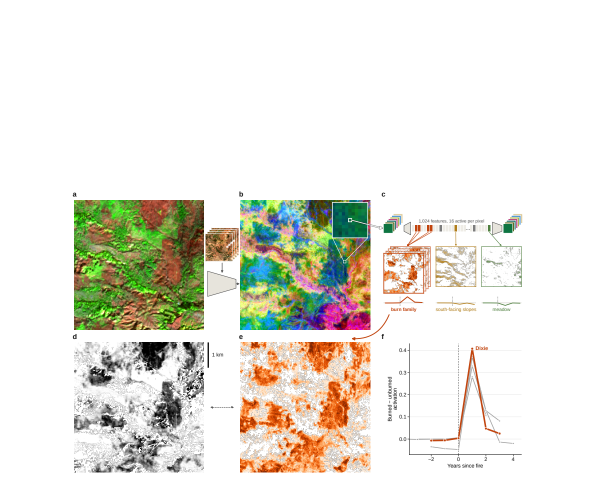
Both embedding products are trained on Sentinel-1/2; the screening severity layer (Fig. 1d; Note S1) is computed from Sentinel-2; and EFDA, Hansen GFC and JRC GSW are Landsat/Sentinel optical composites. Scored against those products are Europe harvest/wind/fire (826 + 352 + 151 units), Amazon/Africa/East Asia forest loss (546 + 140 + 317) and new permanent water (158): 2,490 of the 3,703 dated held-out units, about 67%. The temporal hold-out does not control for spatially recurrent artifacts (persistent cloud-masked areas, regrowth lag, compositing gaps), and the assertion that reference errors 'mostly reduce agreement' fails exactly in the correlated case: if both sides share the same optical compositing, agreement can be inflated. The hand-mapped, field-checked landslide inventories — the most sensor-independent references in the corpus — cover 71 dated units, 1.9%; with FOR WIND added, 160 units, about 4%. To be clear, the temporal hold-out and the random-family null are strong controls against screening artifacts; the residual issue is specifically correlated-error inflation, which they do not address. I request one or more of: (i) validation rates reported separately by reference tier; (ii) a cross-reference agreement test on events carrying two references (Vaia has both FOR WIND and EFDA dates); (iii) a rough bound on shared-error inflation, for example by measuring family-reference agreement where independent references disagree. At minimum, the phrase 'independent reference data' in the abstract should be qualified, since most of the dated validation rests on products that share the embeddings' sensor pipeline.
The paper says, at §2.6; Fig. 6; §4.7
The review did not quote this passage.
Pith says: Objection 2 of 2 · major
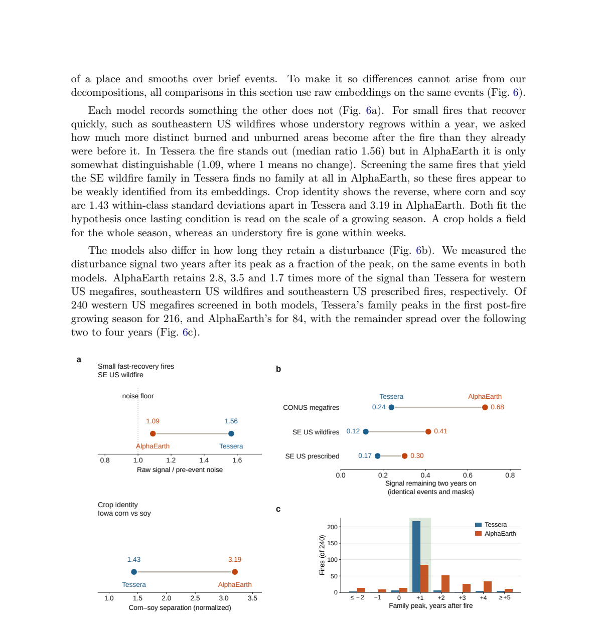
The most novel practical claim in the abstract — that small fires that recover quickly are detectable in one product but not the other — rests on evidence without uncertainty quantification. The southeastern US wildfire comparison uses 21 events (Fig. 6a caption); the signal-to-noise ratios 1.56 (Tessera) and 1.09 (AlphaEarth, at the noise floor) are point estimates with no interval, and a single identical screen yields 15 features in Tessera and none in AlphaEarth over those 21 events.
more of objection 2
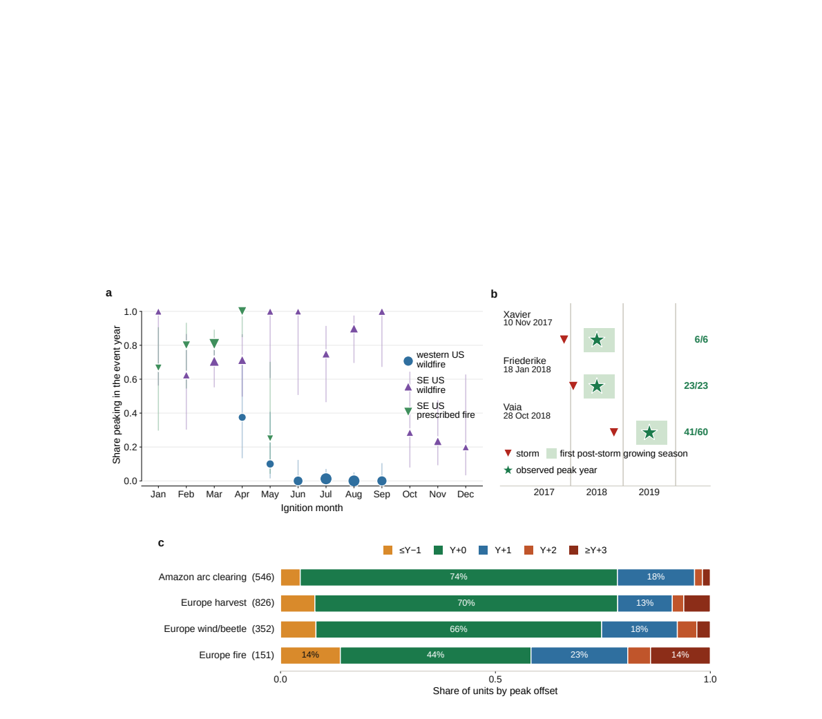
This contrasts with the paper's otherwise systematic use of tile-clustered bootstraps for validation rates (§4.5). Please add tile-clustered bootstrap or permutation intervals for the Fig. 6a ratios, a permutation null for the 15-versus-0 feature count (for example, the number of features that the identical screen returns on random size-matched subsets of the 21 events in AlphaEarth), and intervals for the retention fractions in Fig. 6b. The 240-megafire peak-offset result (216 vs 84 of 240 peaking in the expected window, Fig. 6c) is the most robust piece of the dissociation and would be a more appropriate primary support for the claim than the n = 21 comparison.
6 minor objections
The paper says, at Table S2; §4.5
Pith says: minor objection 1 of 6
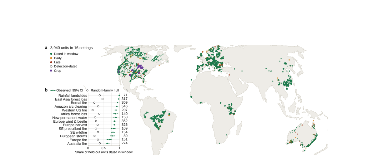
For the two settings closest to their nulls, the reported bounds are coarse: SE Australia (observed 0.624, null median 0.369, null 95% interval [0.201, 0.639]) and Europe fire (0.669 vs [0.159, 0.543]). Because the observed SE Australia rate lies within the null's reported 95% interval, please report the exact one-sided P-value or the number of the 200 null draws reaching the observed rate for every dated setting, so the claim 'P ≤ 0.05' is checkable per setting.
The paper says, at §4.4; Abstract
Pith says: minor objection 2 of 6
The abstract's 'date abrupt canopy loss' (b3) is stronger than the operational definition in §4.4, where a held-out unit validates when its family's mean activation contrast is highest inside the expected window, computed with the reference mask and reference year given.
more of objection 2
The validation therefore establishes that within reference-defined disturbance areas the family contrast follows the reference year; it does not establish that the embeddings localize new events in previously unmapped areas. A sentence in §3 or §4.4 making the mask-conditional nature of the dating metric explicit would prevent the headline from being read as event detection.
show 4 more
The paper says, at §2.5; Fig. 5a; Note S10
Pith says: minor objection 3 of 6
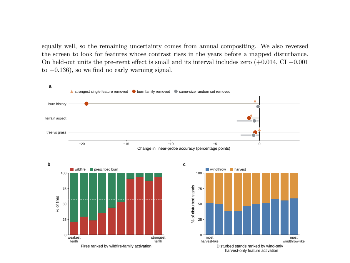
The 19-point ablation drop is measured on the Dixie tile, where the burn family was screened; the text states this, but the claim that the family is 'how the embedding represents fire' rather than a correlate would be more strongly supported by repeating the ablation on the held-out fires of Fig. 1f (North Complex, Caldor, Mosquito), where the family was not screened.
The paper says, at Data availability; §4.6
Pith says: minor objection 4 of 6
The Data availability list omits several products used in the main validation: JRC Global Surface Water, the three landslide inventories, the JRC EU crop maps, ESA WorldCover, the Copernicus DEM, and the mining and solar datasets. As written it falls short of the 'All data products used are publicly available' sentence in §4.6; please complete the list.
The paper says, at §4.3; Fig. 6; Note S3
Pith says: minor objection 5 of 6
Presentation points: in Note S3, 'the corpus does not depend on the choice' should say 'the unit corpus', since Table S1 shows the feature families themselves change size with the multiplier. The Fig. 6c caption phrase 'both screened' should read 'screened in both models'. Data availability spells the product 'Geotessera' while §4.1 uses 'GeoTessera'.
The paper says, at §3 Discussion
Pith says: minor objection 6 of 6
The Discussion's coherence argument — that features peaking before fires or separating causes with identical surfaces would have pointed to artifacts — is reasonable corroboration, but it is not an artifact control of the same strength as the random-family nulls and the held-out design; consider presenting it explicitly as corroborative rather than as decisive evidence.
What would settle it
Re-run the Europe harvest setting (the largest dated setting, n=826) with the identical embedding, dictionary, screening rule and expected window, but replace EFDA labels on a random sample of tiles with harvest-year labels from an independent source that does not use the same optical composites—for example, national forest inventory clearcut records or aerial-photograph/field-based disturbance mapping. If the held-out dating rate stays near 0.832 and far above the 0.301 random-family null, the shared-sensor concern does not land for the bulk of the corpus; if it falls toward the null, the reported rates are inflated by reference-embedding error correlation and the abstract's 'independent reference data' must be qualified.
from the skeptic's reading
How the review went
4 readings by deepseek-v4-flash · 26 Oct 2026
- Reader holds up, with conditions
- Skeptic agrees
- Editor wrote the verdict above
- Referee major revision: 2 major objections, 6 minor
Not run on this paper: the simulated authors' defence.
Pith did not check this review's objections against the paper.
The review in full
The review in brief, machine-written
Read it twice. Bottom line: this is a real contribution, and the central claim holds up better than I expected, but the one assumption that worries me is exactly the one the authors flag in the Discussion: reference-product errors are treated as largely independent of the embeddings, and that is left unquantified.
What's new: applying sparse autoencoders to annual Earth embeddings and testing the resulting features by when they activate, not just where. That temporal test—contrast must be quiet before the event, peak inside a pre-fixed window, decay afterward—is a genuinely better check that a feature means something than correlating with a static covariate. The validation design is careful: families screened on earliest-year units, scored on later years, never-seen storms, never-seen continents, always against same-size random feature sets from the same dictionary. The nulls are fair, and the sensitivity sweeps over the screening threshold and dictionary seeds are reassuring. The cross-model dissociation on identical events is strong evidence, and it partly offsets the fact that one of the two products is the authors' own. The citation pattern is fine; the external references carry the argument.
Soft spots, in proportion. The main one is the independent-reference premise. Roughly two-thirds of the dated units rely on Landsat/Sentinel optical composites (EFDA, Hansen GFC, JRC GSW), while the embeddings are trained on Sentinel-1/2. The authors concede the issue but do not bound it. A feature family could in principle be tracking recurring artifacts of the shared optical archive—persistent cloud masking, regrowth lag, compositing gaps—and still pass the temporal hold-out, because those artifacts repeat in the same locations. The temporal screen and random nulls rule out chance, not shared systematic error. I don't think this is fatal: event-dated and radar/field references (MTBS dates, FOR WIND, landslide inventories, RADD) behave consistently, and the cross-model comparison uses raw embeddings on identical events rather than reference agreements. But the paper would be much stronger with validation rates reported separately for the subgroups whose references do not share the optical Sentinel/Landsat lineage, or a concrete argument for why shared artifacts cannot reproduce the cross-continent pattern. The sentence "Errors in the reference products mostly reduce agreement" is asserted; correlated errors can inflate agreement, so that sentence needs support.
Two minor things. No code or configurations ship, so the central pipeline is rebuildable from the Methods but not immediate. And the headline 85% absolute rate should be quoted with the caveat that expected windows are pre-fixed and, for detection-dated data, reasonably generous at {Y, Y+1}; the null comparisons remain fair, so this is a presentation issue, not a statistical one.
Who this is for: anyone building monitoring, carbon, or compliance systems on annual Earth embeddings, and the interpretability community. It deserves a serious referee. I would send it out and ask for the quantitative independence check plus code release; my own read is that the claim that annual embeddings are decomposable records of the land surface is supported, with that caveat attached.
The strongest objection
Load-bearing premise: validation against 'independent reference data' is what turns SAE features into 'records of the land surface.' The Discussion concedes this premise ('This assumes the reference errors are largely independent of the embeddings, which may not hold where both derive from similar satellite data', sentence b171), but the concession is the weak point, not a resolution. The dNBR layer used for screening (Fig. 1d, Supplementary Note S1) is computed from Sentinel-2; EFDA, Hansen GFC and JRC GSW are Landsat/Sentinel optical composites. The units scored against those products—Europe harvest/wind/fire, Amazon/Africa/East Asia forest loss, new permanent water—account for 2,490 of the 3,703 dated units (about 67%). Tessera and AlphaEarth are trained on Sentinel-1/2, so both sides share the same optical reflectance, atmospheric correction, cloud/shadow handling and annual compositing. A feature family could therefore be a detector of the reference products' systematic artifacts (persistent cloud-masked pixels, regrowth lag, compositing gaps) and still pass every held-out dating test in this paper; the temporal hold-out does not remove artifacts that recur in the same locations. The field-checked landslide inventories and agency-derived MTBS/FOR WIND perimeters are more independent, but they are the minority. The authors acknowledge the issue but give no quantitative bound on how much shared-sensor error could inflate the reported 85% rate. That missing bound is the load-bearing concern.
The reader's weakest assumption is also the one I would flag: reference-product errors are assumed independent of embedding errors, and the bulk of the validation corpus does not satisfy that assumption in a strong sense. I agree with the reader that this is load-bearing because nearly every headline number—the 85% dated rate, the per-setting bars in Fig. 3b, and the dNBR-based demonstration—compares embedding-derived features against products built from the same optical satellite family. I do not treat this as a new finding: the Discussion states it in one sentence (b171). What is unresolved is magnitude. The paper's claim that 'errors in the reference products mostly reduce agreement' is an assumption, not a demonstrated bound; with shared sensors, correlated errors can instead inflate agreement. The proposed test isolates that magnitude on the largest setting. The code-release and expected-window caveats raised by the reader are real but secondary. Since the reader's CONDITIONAL verdict already rests on this concern, my read does not move the verdict; I would keep CONDITIONAL and make the sensor-stratified revalidation an explicit condition for ACCEPT.
The referee's report
If the results hold, this is a substantial, reusable contribution: it answers the open interpretability question for Earth embeddings [1] with SAE decomposition plus temporal external verification, and shows that two products trained on the same observations are not interchangeable for monitoring small, fast-recovering disturbances. Strengths of the design: families are screened on a subset and scored only on held-out units; every dated setting is compared with a same-size random-feature null that is conservative in 12 of 14 settings (Table S3); rates are stable across a 16-fold threshold range (Table S1) and across seeds; the ablation (Fig. 5a) uses matched random controls; and the RADD and precursor tests turn negative findings into bounds on temporal resolution. The main risk is the shared-sensor dependence between the Sentinel-1/2-trained embeddings and the optical-composite reference products scoring about two-thirds of dated units.
Pith's reading of the paper (a machine's summary, not the authors')
Annual Earth embeddings—learned vectors that compress a year of satellite imagery into a few dozen or hundred numbers for every ten-meter pixel—are now consumed as standard inputs for ecological monitoring, carbon accounting, and compliance, but what they actually contain had not been established. This paper decomposes two public global embedding products with sparse autoencoders and shows that individual directions in the space carry specific, verifiable surface phenomena: fire, forest clearing, crop type, new water, mining land, and solar farms. Feature families screened on a subset of events date 85% of 3,703 held-out disturbances to their expected calendar window, against random-feature baselines of 0.14 to 0.46, in all 14 dated settings on six continents. Removing the burn family from an embedding costs a fire-detection probe 19 accuracy points while a matched random set does nothing, which the authors read as evidence the features are how the embedding represents fire rather than a correlate of it. The two products, trained on largely the same Sentinel observations, retain different phenomena: Tessera captures small fast-recovering fires that AlphaEarth nearly misses, while AlphaEarth separates corn from soy far more cleanly.
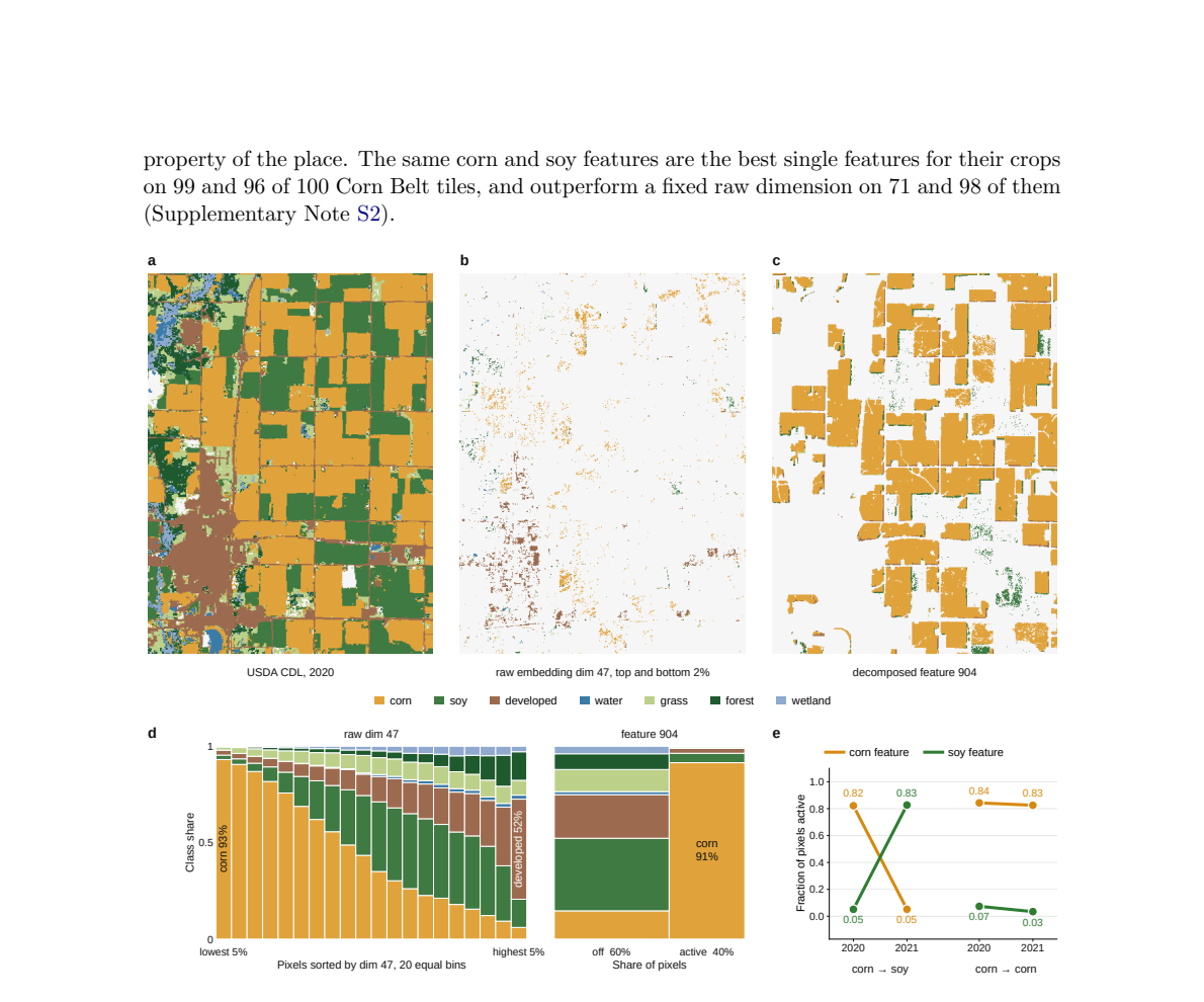
What carries the argument. The TopK sparse autoencoder ($m=1024$ features, $k=16$ active per pixel on Tessera, matched $8 imes$ expansion on AlphaEarth) rewrites each annual embedding as a weighted sum of a few non-negative features, giving each feature a near-monomorphic meaning, in contrast to a raw embedding dimension whose two extremes are different classes, such as corn at one tail and developed land at the other. The load-bearing screening rule is the timing contrast: a feature joins a family only if its disturbed-minus-intact activation peaks inside a setting's expected window, stays quiet in every earlier year, and decays from the third year onward. Applying that 'when it appears' test—families screened on a subset of events and scored on the held-out remainder—is what converts a learned dictionary of directions into verifiable records of dated surface events.
Core claim. The central claim is that annual Earth embeddings are not opaque blobs but decomposable, interpretable records of the land surface. A sparse autoencoder rewrites each embedding as a weighted sum of a few active dictionary features, and when features are screened by the timing of their disturbed-minus-intact contrast, the survivors behave like named concepts: a burn family appears only after a fire, decays afterwards, transfers without modification to other fires and continents, and—as ablation shows—carries the information a linear probe uses to detect fire. Disturbances are dated to the calendar year containing the first growing season that shows the disturbed surface, which is why western conifer fires peak the year after burning while southeastern understory regrows within weeks and peaks in the event year, and why three European windstorms on either side of a calendar boundary peak in the predicted post-storm growing season. Severity is resolved well enough for a single threshold to separate prescribed fire from wildfire, but cause is not: windthrow, bark-beetle damage, and harvest share most features because they leave the same surface. Tessera and AlphaEarth, observing the same planet, record different phenomena on identical events, consistent with their training objectives treating time differently—one event-indexed, one state-indexed.
The premise it rests on. The validation rates assume errors in the reference products are largely independent of the embeddings, but the embeddings and most reference layers derive from the same Sentinel and Landsat optical archives, so shared systematic blind spots could make the true agreement with ground reality lower than the reported figures.
If the paper is right (Pith's inferences, not the authors')
A user can screen any embedding product, open or closed, for a target phenomenon at the required temporal resolution before building a monitoring or compliance system, needing only the embeddings and a reference product for that phenomenon.
Disturbances are placed in the calendar year of the first post-disturbance growing season, not the event year, so downstream models that assume event-year dating will systematically misplace western conifer fires by a year.
The two embedding products are not interchangeable: for small fast-recovering fires, Tessera carries a signal at 1.56 times pre-event noise while AlphaEarth sits near its noise floor at 1.09, whereas AlphaEarth separates corn from soy at 3.19 within-class deviations against Tessera's 1.43.
Benchmarks that score only the tasks they include cannot certify that a phenomenon absent from the benchmark is present in a model, and the two products' divergence on identical events shows that benchmark parity can mask real differences in what an embedding retains.
The embeddings record what a disturbance did to the surface, not what caused it, so causes that leave identical surface signals—windthrow, beetle damage, harvest—cannot be separated by this decomposition.
If the event-indexed versus state-indexed distinction is causal rather than correlational, it predicts a general trade-off in Earth embedding objectives between retaining brief abrupt events and tracking persistent state; training one model family on a fixed Sentinel subsample with varying objectives would test the mechanism the paper could only observe in the two available products.
The screening machinery could be run inverted as an unmapped-event detector: decompose each new annual embedding and flag any feature whose activation appears strongly outside all mapped events, giving an independent audit channel against reference-record omissions.
Because the corn and soy features follow field rotation (82% to 5% and 5% to 83% on CDL-recorded switches), the decomposition is a candidate mechanism for crop mapping from embeddings that tracks the crop in the field year by year, which may matter for small-field agriculture where parcel-level maps have been unreliable.
Feature families screened in one region and transferred to another hint that interpretability built on one product's dictionary could transfer to other products trained on similar data, which would make decomposition-based audits portable rather than per-product efforts.
Check this review
Pith stored no record of this review's passes and took no fingerprint of it. Reviews made by code from 13 Nov 2026 on carry both.
How often reviews like this one are right
Reviews like this one: written by deepseek-v4-flash, where what was read was not recorded.
How often objections from reviews like this one are right: not yet measured
Reviews by people
This review was written by a machine. No person has reviewed this paper on Pith yet. A scientist listed on Pith can review it for a fee, and their review is published here whatever it concludes.
The paper
Abstract
Ecological monitoring, carbon accounting and biodiversity assessment increasingly rely on annual Earth embeddings–learned vectors that compress a year of satellite observation for every ten-meter pixel on Earth, consumed in place of the imagery itself. What these vectors mean has not been established. Here we decompose two widely used embedding products and show that they contain individual ecological features, including fire, forest clearing and crop type, validated against independent reference data on events across six continents. The recovered concepts date abrupt canopy loss to the first post-disturbance growing season and resolve severity well enough to separate prescribed fire from wildfire. Small fires that recover quickly are detectable in one product but not the other, which instead separates crops more strongly.
The paper's own sentences, arranged, kept beside the review and separate from it. Each label is drawn from a closed vocabulary; the number beside it is the probability the classifier gave that label. No sentence in this record was written by a model.
abstract compiled · 2026-10-26
The authors' main claim, as the classifier picked it out 1.00
“Here we decompose two widely used embedding products and show that they contain individual ecological features, including fire, forest clearing and crop type, validated against independent reference data on events across six continents.”
How the main claim is stated: asserted 1.00
What the abstract itself states, as probabilities: claims first 0.09 · states limitation 0.78 · human participants 0.03 · controlled comparison 0.12 · randomized assignment 0.02 · states quantitative result 0.15 · compares with prior results 0.54 · mentions code or data availability 0.04
The abstract, sentence by sentence
This table labels the abstract only (arXiv listing abstract v1). The number is the probability the classifier gave the label.
| Sentence | Role | The authors' own work | States the main conclusion | Strength |
|---|---|---|---|---|
| Ecological monitoring, carbon accounting and biodiversity assessment increasingly rely on annual Earth embeddings--learned vectors that compress a year of satellite observation for every ten-meter pixel on Earth, consumed in place of the imagery itself. | background 1.00 | 0.07 | 0.03 | asserted 1.00 |
| What these vectors mean has not been established. | gap 1.00 | 0.05 | 0.02 | asserted 0.94 |
| Here we decompose two widely used embedding products and show that they contain individual ecological features, including fire, forest clearing and crop type, validated against independent reference data on events across six continents. | contribution 0.89 | 0.96 | 0.83 | asserted 1.00 |
| The recovered concepts date abrupt canopy loss to the first post-disturbance growing season and resolve severity well enough to separate prescribed fire from wildfire. | result 1.00 | 0.94 | 0.18 | asserted 1.00 |
| Small fires that recover quickly are detectable in one product but not the other, which instead separates crops more strongly. | result 0.99 | 0.89 | 0.06 | asserted 0.99 |
What kind of paper the classifier reports this is: empirical study 0.71 · evidence from analysis of existing data 0.95
What was examined, and what was not
Sources read
- arXiv listing abstract v1
Not examined
- full text
- figures and tables
- references and citing sentences
- relations to other papers
Levels run
- P abstract
Not run
- S sections
- T body sentences
- C citations
- R cross-paper relations
How the labels were made
Compiled by classifier-1.13.0 via TypeSafe API, question bank abstract-p1-20260923, 2026-10-26: 1 request, 4,230 input tokens.
Every quoted sentence on this record is the authors'. Every label is from Pith's closed vocabulary, with the probability shown beside it. This record as JSON
Figures (6)
Figures are the authors', reproduced from the paper.
References (65)
- [1] Konstantin Klemmer, Esther Rolf, Marc Rußwurm, Gustau Camps-Valls, Mikolaj Cz- erkawski, Stefano Ermon, Alistair Francis, Nathan Jacobs, Hannah Kerner, Lester Mackey, Gengchen Mai, Oisin Mac Aodha, Markus Reichstein, Caleb Robinson, David Rolnick, 13 Evan Shelhamer, Vincent Si... on Pithdoi:10.1109/mgrs.2026.3710416
- [2] Johannes Jakubik, Sujit Roy, C. E. Phillips, Paolo Fraccaro, Denys Godwin, Bianca Zadrozny, Daniela Szwarcman, Carlos Gomes, Gabby Nyirjesy, Blair Edwards, Daiki Kimura, Naomi Simumba, Linsong Chu, S. Karthik Mukkavilli, Devyani Lambhate, Ka- mal Das, Ranjini Bangalore, Dario ... on PithPith's reviewarXiv
- [3] Gabriel Tseng, Ruben Cartuyvels, Ivan Zvonkov, Mirali Purohit, David Rolnick, and Han- nah Kerner. Lightweight, pre-trained transformers for remote sensing timeseries, 2024. URL https://arxiv.org/abs/2304.14065 on PithPith's reviewarXiv
- [4] Yezhen Cong, Samar Khanna, Chenlin Meng, Patrick Liu, Erik Rozi, Yutong He, Mar- shall Burke, David B. Lobell, and Stefano Ermon. Satmae: pre-training transformers for temporal and multi-spectral satellite imagery. InProceedings of the 36th International Con- ference on Neural... on Pith
- [5] Zhitong Xiong, Yi Wang, Fahong Zhang, Adam J. Stewart, Jo¨ elle Hanna, Damian Borth, Ioannis Papoutsis, Bertrand Le Saux, Gustau Camps-Valls, and Xiao Xiang Zhu. Neural plasticity-inspired multimodal foundation model for earth observation, 2025. URLhttps: //arxiv.org/abs/2403.15356 on PitharXiv
- [6] Gabriel Tseng, Anthony Fuller, Marlena Reil, Henry Herzog, Patrick Beukema, Favyen Bastani, James R Green, Evan Shelhamer, Hannah Kerner, and David Rolnick. Galileo: Learning global & local features of many remote sensing modalities. In Aarti Singh, Maryam Fazel, Daniel Hsu, S... on Pith
- [7] Henry Herzog, Favyen Bastani, Yawen Zhang, Gabriel Tseng, Joseph Redmon, Hadrien Sablon, Ryan Park, Jacob Morrison, Alexandra Buraczynski, Karen Farley, Joshua Hansen, Andrew Howe, Patrick Alan Johnson, Mark Otterlee, Ted Schmitt, Hunter Pitelka, Stephen Daspit, Rachel Ratner,... on Pith
- [8] Zhengpeng Feng, Clement Atzberger, Sadiq Jaffer, Jovana Knezevic, Silja Sormunen, Robin Young, Madeline C. Lisaius, Markus Immitzer, Toby Jackson, James Ball, David A. Coomes, Anil Madhavapeddy, Andrew Blake, and Srinivasan Keshav. Tessera: Temporal embeddings of surface spect... on Pith
- [9] Christopher F. Brown, Michal R. Kazmierski, Valerie J. Pasquarella, William J. Rucklidge, Masha Samsikova, Chenhui Zhang, Evan Shelhamer, Estefania Lahera, Olivia Wiles, Simon Ilyushchenko, Noel Gorelick, Lihui Lydia Zhang, Sophia Alj, Emily Schechter, Sean Askay, Oliver Guina... on PithPith's reviewarXiv
- [10] Yuchi Ma, Yawen Shen, Anu Swatantran, and David B. Lobell. Harvesting AlphaEarth: Benchmarking the geospatial foundation model for agricultural downstream tasks.Inter- national Journal of Applied Earth Observation and Geoinformation, 149:105258, 2026. doi: 10.1016/j.jag.2026.105258 on Pithdoi:10.1016/j.jag.2026.105258
- [11] Maxwell B. Joseph, Fl´ avia De Souza Mendes, Dieu My T. Nguyen, Camile Sothe, and Christopher B. Anderson. Continuous biome representations from earth observation em- beddings, 2026. URLhttps://arxiv.org/abs/2606.11510 on PithPith's reviewarXiv
- [12] Madeline C. Lisaius, Andrew Blake, Clement Atzberger, and Srinivasan Keshav. Towards improved crop type classification: a compact embedding approach suitable for small fields. InISPRS Annals of the Photogrammetry, Remote Sensing and Spatial Information Sciences, volume XI-2-20... on Pithdoi:10.5194/isprs-annals-xi-2-2026-873-2026
- [13] James G. C. Ball, Jana Annika Wicklein, Zhengpeng Feng, Jovana Knezevic, Sadiq Jaffer, Anil Madhavapeddy, Clement Atzberger, Michele Dalponte, and David A. Coomes. Geospa- tial foundation models enable data-efficient tree species mapping in temperate mountain forests.Science o... on Pithdoi:10.1016/j.srs.2026.100466
- [14] Robin Young, Michael E. Van Nuland, E. Toby Kiers, Tom´ aˇ s Vˇ etrovsk´ y, Petr Kohout, Petr Baldrian, and Srinivasan Keshav. Below-ground fungal biodiversity can be monitored using self-supervised learning satellite features, 2026. URLhttps://arxiv.org/abs/2604. 09818 on Pith
- [15] Shawn Ryan, Megan Powell, Joanne Ling, and Li Wen. Streamlining wetland vegetation mapping with alphaearth embeddings: Comparable accuracy to traditional methods with cleaner maps and minimal preprocessing.Remote Sensing, 18(2):293, 2026. doi: 10.3390/ rs18020293. URLhttps://d... on Pithdoi:10.3390/rs18020293
- [16] Mohammad Karimi, Ardalan Daryaei, Mehdi Abedi, and Markus Immitzer. Plant species mapping across the miankaleh biosphere reserve and successional patterns in its drying wetland: A remote sensing-based assessment.Ecological Informatics, 96:103822, 2026. doi: 10.1016/j.ecoinf.20... on Pithdoi:10.1016/j.ecoinf.2026.103822
- [17] Mashrekur Rahman. Physically interpretable AlphaEarth foundation model embeddings enable LLM-based land surface intelligence.Remote Sensing Applications: Society and Environment, 42:102045, 2026. doi: 10.1016/j.rsase.2026.102045 on Pithdoi:10.1016/j.rsase.2026.102045
- [18] Yihang She, Andrew Blake, Jianbo Qi, and Srinivasan Keshav. Pico: Physics-informed concept probing for geo-foundation models, 2026. URLhttps://arxiv.org/abs/2610. 20973 on Pith
- [19] Rohita Mocharla and Vishal M. Patel. Probing geospatial ssl representations with environ- mental signals, 2026. URLhttps://arxiv.org/abs/2607.05207. 15 on PithPith's reviewarXiv
- [20] Julia Romero, Qin Lv, and Morteza Karimzadeh. How do self-supervised remote sensing vision models transfer to downstream tasks?, 2026. URLhttps://arxiv.org/abs/2606. 13896 on Pith
show 45 more
- [21] Livia Betti, Sebastian Ricke, Ivica Obadic, Adam J. Stewart, and Esther Rolf. What’s in an earth embedding? an explainability analysis of location encoders, 2026. URLhttps: //arxiv.org/abs/2606.24997 on PithPith's reviewarXiv
- [22] Elijah Cole, Grant Van Horn, Christian Lange, Alexander Shepard, Patrick Leary, Pietro Perona, Scott Loarie, and Oisin Mac Aodha. Spatial implicit neural representations for global-scale species mapping. In Andreas Krause, Emma Brunskill, Kyunghyun Cho, Bar- bara Engelhardt, S... on Pith
- [23] Alexandre Lacoste, Nils Lehmann, Pau Rodriguez, Evan David Sherwin, Hannah Kerner, Bj¨ orn L¨ utjens, Jeremy Irvin, David Dao, Hamed Alemohammad, Alexandre Drouin, Mehmet Gunturkun, Gabriel Huang, David Vazquez, Dava Newman, Yoshua Ben- gio, Stefano Ermon, and Xiao Xiang Zhu. ... on Pith
- [24] Valerio Marsocci, Yuru Jia, Georges Le Bellier, David Kerekes, Liang Zeng, Sebas- tian Hafner, Sebastian Gerard, Eric Brune, Ritu Yadav, Ali Shibli, Heng Fang, Yifang Ban, Maarten Vergauwen, Nicolas Audebert, and Andrea Nascetti. PANGAEA: As- sessing geospatial foundation mode... on Pithdoi:10.1109/mgrs.2025.3628194
- [25] Naomi Simumba, Nils Lehmann, Paolo Fraccaro, Hamed Alemohammad, Geeth De Mel, Salman Khan, Manil Maskey, Nicolas Long´ ep´ e, Xiao Xiang Zhu, Hannah Kerner, Juan Bernabe Moreno, and Alexandre Lacoste. GEO-bench-2: From performance to capa- bility, rethinking evaluation in geos... on Pith
- [26] Adrian H¨ ohl, Ivica Obadic, Miguel- ´Angel Fern´ andez-Torres, Hiba Najjar, Dario Au- gusto Borges Oliveira, Zeynep Akata, Andreas Dengel, and Xiao Xiang Zhu. Open- ing the black box: A systematic review on explainable artificial intelligence in remote sensing.IEEE Geoscience... on Pithdoi:10.1109/mgrs.2024.3467001
- [27] Hoagy Cunningham, Aidan Ewart, Logan Riggs, Robert Huben, and Lee Sharkey. Sparse autoencoders find highly interpretable features in language models. InThe Twelfth Inter- national Conference on Learning Representations, 2024. URLhttps://openreview.net/ forum?id=F76bwRSLeK on Pith
- [28] Trenton Bricken, Adly Templeton, Joshua Batson, Brian Chen, Adam Jermyn, Tom Con- erly, Nick Turner, Cem Anil, Carson Denison, Amanda Askell, Robert Lasenby, Yifan Wu, Shauna Kravec, Nicholas Schiefer, Tim Maxwell, Nicholas Joseph, Zac Hatfield-Dodds, Alex Tamkin, Karina Nguye... on Pith
- [29] Joshua J. Picotte, Krishna P. Bhattarai, Daniel Howard, Jennifer Lecker, Justin Ept- ing, Brad Quayle, Nate Benson, and Kurtis Nelson. Changes to monitoring trends in burn severity program’s production procedures and data products.Fire Ecology, 16 (16):1–12, 2020. doi: 10.1186... on Pithdoi:10.1186/s42408-020-00076-y
- [30] Jeff Eidenshink, Brian Schwind, Kenneth Brewer, Zhi-Liang Zhu, Brad Quayle, and Stephen Howard. A project for monitoring trends in burn severity.Fire Ecology, 3(1):3–21, 2007. doi: 10.4996/fireecology.0301003. URLhttps://doi.org/10.4996/fireecology.0301003 on Pithdoi:10.4996/fireecology.0301003
- [31] Geoscience Australia. Bushfire historical extents - version 3.0, 2024. URLhttps://doi. org/10.26186/149978 on Pithdoi:10.26186/149978
- [32] Alba Viana-Soto and Cornelius Senf. The european forest disturbance atlas: a forest dis- turbance monitoring system using the landsat archive.Earth System Science Data, 17 (6):2373–2404, 2025. doi: 10.5194/essd-17-2373-2025. URLhttps://doi.org/10.5194/ essd-17-2373-2025 on Pithdoi:10.5194/essd-17-2373-2025
- [33] Alba Viana-Soto and Cornelius Senf. European forest disturbance atlas (version 2.1.1), on Pith
- [34] Giovanni Forzieri, Matteo Pecchi, Marco Girardello, Achille Mauri, Marcus Klaus, Christo Nikolov, Marius R¨ uetschi, Barry Gardiner, Juli´ an Tomaˇ st ´ ık, David Small, Constantin Nis- tor, Donatas Jonikavicius, Jonathan Spinoni, Luc Feyen, Francesco Giannetti, Rosario Comino... on Pith
- [35] M. C. Hansen, P. V. Potapov, R. Moore, M. Hancher, S. A. Turubanova, A. Tyukavina, D. Thau, S. V. Stehman, S. J. Goetz, T. R. Loveland, A. Kommareddy, A. Egorov, L. Chini, C. O. Justice, and J. R. G. Townshend. High-resolution global maps of 21st-century forest cover change.Sc... on Pithdoi:10.1126/science.1244693
- [36] Johannes Reiche, Abel Mullissa, Bart Slagter, Yifan Gou, Nandin-Erdene Tsendbazar, Cyn- thia Odongo-Braun, Anja Vollrath, Martin J. Weisse, Fred Stolle, Amy Pickens, Gennadii Donchyts, Nicholas Clinton, Noel Gorelick, and Martin Herold. Forest disturbance alerts for the congo ... on Pithdoi:10.1088/1748-9326/abd0a8
- [37] Claire Boryan, Zhengwei Yang, Rick Mueller, and Mike Craig. Monitoring us agriculture: the us department of agriculture, national agricultural statistics service, cropland data layer program.Geocarto International, 26(5):341–358, 2011. doi: 10.1080/10106049.2011.562309. URLhtt... on Pithdoi:10.1080/10106049.2011.562309
- [38] Matteo Berti, Marco Pizziolo, Michele Scaroni, Mauro Generali, Vincenzo Critelli, Marco Mulas, Melissa Tondo, Francesco Lelli, Cecilia Fabbiani, Francesco Ronchetti, Giuseppe Ciccarese, Nicola Dal Seno, Elena Ioriatti, Rodolfo Rani, Alessandro Zuccarini, Tommaso Simonelli, and... on Pith
- [39] Hao Ma and Fawu Wang. Inventory of shallow landslides triggered by extreme pre- cipitation in July 2023 in Beijing, China.Scientific Data, 11(1), 2024. doi: 10.1038/ s41597-024-03901-0 on Pith
- [40] Zijin Fu, Fawu Wang, Hao Ma, Qi You, and Youqian Feng. Records of shallow landslides triggered by extreme rainfall in July 2024 in Zixing, China.Scientific Data, 12(1), 2025. doi: 10.1038/s41597-025-05670-w on Pithdoi:10.1038/s41597-025-05670-w
- [41] Jean-Fran¸ cois Pekel, Andrew Cottam, Noel Gorelick, and Alan S. Belward. High-resolution mapping of global surface water and its long-term changes.Nature, 540(7633):418–422, on Pith
- [42] Leo Gao, Tom Dupre la Tour, Henk Tillman, Gabriel Goh, Rajan Troll, Alec Radford, Ilya Sutskever, Jan Leike, and Jeffrey Wu. Scaling and evaluating sparse autoencoders. In The Thirteenth International Conference on Learning Representations, 2025. URLhttps: //openreview.net/for... on Pith
- [43] Robert E. Kennedy, Zhiqiang Yang, and Warren B. Cohen. Detecting trends in forest disturbance and recovery using yearly Landsat time series: 1. LandTrendr — temporal segmentation algorithms.Remote Sensing of Environment, 114(12):2897–2910, 2010. doi: 10.1016/j.rse.2010.07.008 on Pithdoi:10.1016/j.rse.2010.07.008
- [44] Zhe Zhu and Curtis E. Woodcock. Continuous change detection and classification of land cover using all available Landsat data.Remote Sensing of Environment, 144:152–171, 2014. doi: 10.1016/j.rse.2014.01.011 on Pithdoi:10.1016/j.rse.2014.01.011
- [45] Juli G. Pausas and Jon E. Keeley. Evolutionary ecology of resprouting and seeding in fire-prone ecosystems.New Phytologist, 204(1):55–65, October 2014. ISSN 0028-646X, 1469-8137. doi: 10.1111/nph.12921 on Pithdoi:10.1111/nph.12921
- [46] Jeff S. Glitzenstein, William J. Platt, and Donna R. Streng. Effects of Fire Regime and Habitat on Tree Dynamics in North Florida Longleaf Pine Savannas.Ecological Monographs, 65(4):441–476, November 1995. ISSN 0012-9615, 1557-7015. doi: 10.2307/2963498. URL https://esajournal... on Pithdoi:10.2307/2963498
- [47] Juliana Freitas Beyer, Margret K¨ othke, and Melvin Lippe. Assessing the suitability of avail- able global forest maps as reference tools for EUDR-compliant deforestation monitoring. Remote Sensing, 17(17):3012, 2025. doi: 10.3390/rs17173012 on Pithdoi:10.3390/rs17173012
- [48] Ronald J. Hall, Roman S. Skakun, Juha M. Metsaranta, Ren´ e Landry, Robert H. Fraser, David A. Raymond, Matthew Gartrell, Vicki Decker, and Jeremy M. Little. Generating annual estimates of forest fire disturbance in canada: the national burned area composite. International Jou... on Pithdoi:10.1071/wf19201
- [49] Rapha¨ el d’Andrimont, Astrid Verhegghen, Guido Lemoine, Pieter Kempeneers, Michele Meroni, and Marijn van der Velde. From parcel to continental scale – A first European crop type map based on Sentinel-1 and LUCAS Copernicus in-situ observations.Remote Sensing of Environment, ... on Pithdoi:10.1016/j.rse.2021.112708
- [50] Babak Ghassemi, Emma Izquierdo-Verdiguier, Astrid Verhegghen, Momchil Yordanov, Guido Lemoine, ´Alvaro Moreno Mart ´ ınez, Davide De Marchi, Marijn van der Velde, 18 Francesco Vuolo, and Rapha¨ el d’Andrimont. European Union crop map 2022: Earth obser- vation’s 10-meter dive i... on Pithdoi:10.1038/s41597-024-03884-y
- [51] Yu-Tong Cheng, Nguyen Tien Hoang, Lou Maupu, and Keiichiro Kanemoto. Classifying land use within 80,000 mining sites on a global scale.Scientific Data, 13(1), 2026. doi: 10.1038/s41597-026-06681-x on Pithdoi:10.1038/s41597-026-06681-x
- [52] K. Sydny Fujita, Zachary H. Ancona, Louisa A. Kramer, Mary Straka, Tandie E. Gautreau, Dana Robson, Chris Garrity, Ben Hoen, and Jay E. Diffendorfer. Georectified polygon database of ground-mounted large-scale solar photovoltaic sites in the United States.Sci- entific Data, 10... on Pithdoi:10.1038/s41597-023-02644-8
- [53] Matthias Drusch, U. Del Bello, S. Carlier, O. Colin, V. Fernandez, F. Gascon, B. Hoer- sch, C. Isola, P. Laberinti, P. Martimort, A. Meygret, F. Spoto, O. Sy, F. Marchese, and P. Bargellini. Sentinel-2: Esa’s optical high-resolution mission for gmes operational ser- vices.Remo... on Pithdoi:10.1016/j.rse.2011.11.026
- [54] Daniele Zanaga, Ruben Van De Kerchove, Dirk Daems, Wanda De Keersmaecker, Carsten Brockmann, Grit Kirches, Jan Wevers, Oliver Cartus, Maurizio Santoro, Steffen Fritz, My- roslava Lesiv, Martin Herold, Nandin-Erdene Tsendbazar, Panpan Xu, Fabrizio Ramoino, and Olivier Arino. Es... on Pith
- [55] Copernicus Programme. Copernicus dem glo-30, 2021. URLhttps://doi.org/10.5270/ ESA-c5d3d65. 19 Supplementary Information Earth embeddings are decomposable records of the land surface Supplementary Note S1 Reference data products We use public reference data products for our gr... on Pith
- [60] Event-dated products (MTBS July 15 2026 release [29, 30], NBAC [48], Geoscience Aus- tralia’s Historic Bushfire Boundaries [31], FOR WIND v2 [34], and three rainfall-triggered landslide inventories: RER2023, Emilia-Romagna, May 2023 [38]; RLBJ, Beijing, July 2023 [39]; and RLZ... on Pith
- [61] Detection-dated products (European Forest Disturbance Atlas [32, 33], Hansen Global Forest Change GFC-2023-v1.11 [35], and the JRC Global Surface Water yearly water history v1.4 [41]) record the first annual composite in which a disturbance or new water is visible. RADD alerts... on Pith
- [62] Class labels: the USDA Cropland Data Layer [37] for the crop atlas, crop rotation, and US rice and winter wheat in the invariance test; the JRC EU crop map, 2018 [49] and 2022 on Pith
- [63] editions, for European winter wheat in the invariance test (Supplementary Note S9); and, for the non-vegetation surfaces (Supplementary Note S6), the global mining land-use dataset [51] and the US Large-Scale Solar Photovoltaic Database (USPVDB) v4.0 [52] on Pith
- [64] A composited dNBR burn severity layer calculated from Sentinel-2 [53] accessed via Mi- crosoft Planetary Computer on Pith
- [65] We additionally use ESA WorldCover v2 [54] and Copernicus DEM GLO-30 [55] to get co- resident probe targets for ablation controls, and in the landslide setting to exclude built-up land, water and snow from the undisturbed pixels and to set their slope floor. We reproject raste... on Pith
- [2016] doi: 10.1038/nature20584 on Pithdoi:10.1038/nature20584
- [2024] URLhttps://doi.org/10.5281/zenodo.13333034 on Pithdoi:10.5281/zenodo.13333034
- [2025] doi: 10.5194/essd-17-1055-2025 on Pithdoi:10.5194/essd-17-1055-2025
- [2026] ISSN 2835-8856. URLhttps://openreview.net/forum?id=NPf175jnP1 on Pith
Cited by 1 Pith paper
Reviewed papers on Pith that cite this one. The full citation record
- Decomposing Earth Embeddings with Sparse Autoencoders cs.LG · Nov 2026
Challenges and discussion
Disagree with the review, or know something it missed? Leave a comment, or challenge this review formally: a challenge becomes a permanent entry in this paper's record, and its decision is published here.
Come back by email
A short list of the week's newly reviewed papers. Nothing is sent until you confirm from your inbox, and every email has a link that stops it. No account.
No comments yet.
Sign in to comment