REVIEW 5 major objections 5 minor 1 cited by
UAV-Based Intelligent Traffic Surveillance System: Real-Time Vehicle Detection, Classification, Tracking, and Behavioral Analysis
T0 review · 5 major / 5 minor · reviewed 2026-08-05 · deepseek-v4-flash
Pith's one-line read Drone traffic system hits 91.8% precision without deep learning
desk verdict Honest case study of a template-matching UAV surveillance system, but the paper contradicts itself about what was actually evaluated, so the headline metrics don't support the claims. read the letter →
The pith
A machine-rendered reading of the paper's core claim, the machinery that carries it, and where it could break.
The reading
What carries the argument
Multi-scale and multi-angle template matching via normalized cross-correlation: an image pyramid and rotated copies of a vehicle template produce candidate detections at every scale and orientation, with non-maximum suppression leaving one box per vehicle. A constant-velocity Kalman filter then predicts each vehicle's state between frames and fuses new detections to maintain identity through occlusion, while Hungarian assignment pairs predictions with measurements. Rotated bounding boxes are described as part of the design, though the final implementation reports using fixed axis-aligned square boxes. Homography-based calibration, built from manually selected ground reference points, is the
What would settle it
Fly the same system over a second intersection with GPS-equipped probe vehicles and compare: if the homography-based speed estimates differ from GPS by more than a few km/h on a substantial share of passes, or if a second independent annotator's labels disagree with the original manual labels by more than the reported error margins, the claimed generality of the system fails.
Extended reading notes
Core claim
The central claim is that a modular UAV system built from classical computer vision components reaches practical accuracy for real-world aerial traffic surveillance without annotated training datasets or GPU inference. Multi-scale and multi-angle normalized cross-correlation template matching detects vehicles at varying sizes and orientations; non-maximum suppression cleans duplicates; Kalman filtering with Hungarian association maintains tracks through occlusions; and a homography estimated from manually selected reference points maps pixel motion to physical speed and defines geofenced zones for violation detection. On the case-study intersection the system reports 91.8% precision, 89.2% r
Load-bearing premise
The reported accuracy numbers rest on the assumption that manually labeling 100 frames from a single intersection under clear weather gives a bias-free ground truth, and that the pixel-to-world mapping built from a few hand-picked reference points is accurate; neither is checked against independent measurements or a second site.
Editorial extensions
If this is right
- A single hovering drone can replace or supplement fixed camera networks at intersections, giving traffic authorities a deployable sensor that needs no road construction.
- Because the detection pipeline is template-based and needs no labeled dataset, it can be pointed at a new intersection and calibrated with a few reference points rather than trained for months.
- The reported metrics imply that five-class vehicle classification, speed profiles, and violation detection are jointly achievable from 200-meter nadir footage at frame rates suitable for near-real-time use.
- Violation rates such as 16.3% unsafe lane changes near the U-turn and 42.7% of crosswalk obstructions by taxis and private cars give enforcement agencies concrete targets for targeted campaigns.
- The analytics layer (counts, heatmaps, inter-class correlations) turns raw tracks into origin–destination-style and congestion insights for urban planning.
Reading between the lines
- If the performance transfers to other intersections and weather conditions, the main practical limit is the hover constraint: speed estimates rely on a single homography, so the drone must stay quasi-static; a natural extension is dynamic homography from visual landmarks, which the paper lists as future work.
- The validation protocol—100 manually labeled frames from one site—suggests the reported metrics may be optimistic; a stronger test would be continuous validation against loop sensors or GPS probe vehicles on the same streets, something the paper does not report.
- The rule-based classification (size, aspect ratio, contour, color) is transparent but brittle: pickups versus private cars already confuse it, so expanding the template bank or fusing a learned classifier would likely close that gap while keeping the system modular.
Signed reviews
Editorial analysis
A structured set of objections, weighed in public.
Referee Report
Summary. The manuscript describes a UAV-based traffic surveillance system built on multi-scale/multi-angle template matching, non-maximum suppression, Kalman filtering, and homography-based georeferencing. It reports detection precision 91.8%, recall 89.2%, F1 90.5%, MOTA/MOTP 92.1%/93.7%, and classification F1 90.3%, based on 100 manually verified frames from a single intersection in Sari, Iran. The paper also presents speed estimation, traffic-violation detection (unsafe lane changes, double parking, crosswalk obstruction), and analytical visualizations such as heatmaps and correlation plots. The central claim is that this lightweight, modular framework enables accurate real-time aerial traffic surveillance in unstructured urban environments.
Significance. If the reported metrics were reproducible, the system would be a useful low-cost alternative to deep-learning detectors on resource-constrained UAV platforms, and the behavioral analytics could inform urban traffic management. The transparent template-matching design and the modular analytics layer are positive features. However, the manuscript as written does not support these claims: the evaluated system is not described consistently, the real-time claim is contradicted by the implementation section, and the evaluation is too small, unbenchmarked, and lacking uncertainty quantification. The paper likely contains a useful engineering prototype, but the evidence in this version is insufficient to establish the stated accuracy or the real-time capability.
major comments (5)
- [§III.B.4 vs §IV.B.1] The method section defines a rotated-bounding-box pipeline: §III.B.4(5) describes rotated IoU, angle-aware anchors, and a loss function penalizing angular error, with the text mentioning 'during network training' despite §III.B.1 rejecting deep learning. Yet §IV.B.1 states: 'In the final implementation, fixed-size square bounding boxes aligned with the image axes were used instead of rotated ones.' These are incompatible object representations. Because Table I reports results without specifying which representation was used, the detection and tracking metrics cannot be assigned to a reproducible method. The rotated-box and anchor/loss material should be removed or explicitly labeled as untested future work, and the text must state which bounding-box representation produced Table I.
- [Abstract, §I vs §IV.B.1] The title, abstract, and introduction claim real-time operation ('real-time vehicle detection' in the title; 'real-time' repeatedly in §I). Section IV.B.1 says the opposite: 'While the current system processes video footage offline... Real-time implementation is not yet deployed.' No throughput or latency figures are provided. Thus the real-time claim is not supported by the experiments. The paper should either remove all real-time claims or provide an online-processing benchmark with measured frame rates and latency.
- [§IV.B.1, Table I] The quantitative evaluation rests on 100 labeled frames from one intersection under clear weather, with manual verification. The paper reports no error bars, no multiple flight sessions, and no independent test set. Moreover, §III.B.2(3) and §III.B.3(4) state that the NMS IoU threshold and Kalman Q/R are empirically tuned through cross-validation, but the text does not state that the tuning set is disjoint from the 100 evaluation frames. This raises the risk of optimistic, unrepeatable metrics. The authors should either substantially enlarge the evaluation and use separate tuning/test sets or explicitly reframe all numbers as case-study illustrations rather than system-level performance.
- [§IV.B.1] No comparison with a baseline detector or tracker is provided. The paper itself acknowledges: 'Direct comparisons with other vehicle detection systems were not included in this study due to variations in dataset conditions, UAV flight parameters, and algorithmic approaches.' Without a baseline on the same data (e.g., a YOLO variant or a standard tracker such as SORT/DeepSORT), the headline precision and MOTA values are uncontextualized, and the implied competitiveness is not established. At minimum, the paper should cite reported results on comparable drone datasets (e.g., VisDrone) or run an off-the-shelf detector on the same frames.
- [§IV.B.2–§IV.B.4] The speed and violation metrics lack uncertainty quantification and a clearly defined ground-truth protocol. Speed estimates rely on manually selected homography reference points, but no error analysis of the homography is given. Violation rates such as 16.3% (unsafe lane changes), the 11–18% delay increase, and 42.7% (crosswalk offenders) are reported without denominators, confidence intervals, or sensitivity to the 10-second stationary threshold. Table II gives per-class precision/recall/F1 but no per-class sample counts or annotation protocol. These are load-bearing for the behavioral-analysis contribution and need supporting statistics or a downgrade to qualitative observations.
minor comments (5)
- [Eq. (1)] The NCC formula appears garbled: the numerator is missing a closing parenthesis and a stray 'q' appears before the denominator. Please rewrite it cleanly using display math.
- [Various] There are numerous typographical and formatting issues, including 'envirnments', 'the the time interval', 'approprite', and inconsistent spacing in 'UA V'. A thorough language edit is needed.
- [Table I] The meaning of 'Overall Detection Accuracy 90.8' and the percentages 'False Positives 3.5' / 'False Negatives 7.5' should be defined explicitly. Are these rates per frame, per vehicle, or something else?
- [§IV.B.3] The classification results in Table II report 'Private Car' with high F1, but the text says misclassifications occur between Pickup and Private Car. Without per-class confusion counts, the severity of this confusion is unclear.
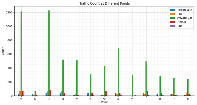
- [Fig. 7 and Fig. 8] The captions describe the heatmaps as geographic/correlation maps, but the text notes they are not geographic and represent counts by location. The captions should be clarified to avoid over-interpretation.
Circularity Check
No significant circularity; the system is an empirical pipeline with standard components and externally measured metrics.
full rationale
The paper does not claim a first-principles derivation; it reports an empirical traffic-surveillance pipeline built from multi-scale/multi-angle template matching, Kalman filtering, and homography-based calibration. The headline detection, classification, and tracking metrics are presented as measured outcomes on 100 manually verified frames, not as quantities obtained by solving the model equations or by fitting a parameter and then renaming the fit as a prediction. The template-matching and Kalman-filter equations are standard textbook material and are not defined in terms of the reported metrics. The only self-citations (e.g., Khan et al., references [1], [23]-[25], which include a co-author) appear in the related-work and background context and are not load-bearing: the paper does not invoke a self-authored uniqueness theorem, ansatz, or fitted parameter to force its conclusions. Threshold tuning of NMS IoU, Kalman noise covariances, and violation dwell times is empirical calibration; while the absence of a clearly separated held-out test set weakens external validity, that is an evaluation-design concern rather than circularity. The internal contradictions between rotated and square bounding boxes and between real-time and offline processing are consistency/reproducibility flaws, but they do not make any claimed result equivalent to its inputs by construction. Therefore no circular step is present.
Assumptions & free parameters
free parameters (8)
- Template matching detection threshold
- NMS IoU threshold =
0.3-0.5 (common range)
- Kalman process noise covariance Q and measurement noise R
- Homography reference points
- Parking/stopping time threshold =
10 seconds
- Lane-change distance threshold =
100 meters
- Classification area/aspect ratio thresholds
- Rotated template angle range and resolution
assumptions (5)
- domain assumption Constant velocity motion model for tracked vehicles
- domain assumption Nadir view and stationary hover during speed estimation
- standard math Homography maps image plane to ground plane
- domain assumption Template matching detects vehicles with sufficient contrast
- ad hoc to paper Traffic rules for violations (e.g., lane change distance, parking duration) are correct
Cite this review
Pith. "Pith review of UAV-Based Intelligent Traffic Surveillance System: Real-Time Vehicle Detection, Classification, Tracking, and Behavioral Analysis." pith.science (2026). https://pith.science/paper/TQ5RR474
@misc{pith2026250904624,
  author       = {Pith},
  title        = {Pith review of: UAV-Based Intelligent Traffic Surveillance System: Real-Time Vehicle Detection, Classification, Tracking, and Behavioral Analysis},
  year         = {2026},
  howpublished = {\url{https://pith.science/paper/TQ5RR474}},
  note         = {Machine review of arXiv:2509.04624}
}
read the original abstract
Traffic congestion and violations pose significant challenges for urban mobility and road safety. Traditional traffic monitoring systems, such as fixed cameras and sensor-based methods, are often constrained by limited coverage, low adaptability, and poor scalability. To address these challenges, this paper introduces an advanced unmanned aerial vehicle (UAV)-based traffic surveillance system capable of accurate vehicle detection, classification, tracking, and behavioral analysis in real-world, unconstrained urban environments. The system leverages multi-scale and multi-angle template matching, Kalman filtering, and homography-based calibration to process aerial video data collected from altitudes of approximately 200 meters. A case study in urban area demonstrates robust performance, achieving a detection precision of 91.8%, an F1-score of 90.5%, and tracking metrics (MOTA/MOTP) of 92.1% and 93.7%, respectively. Beyond precise detection, the system classifies five vehicle types and automatically detects critical traffic violations, including unsafe lane changes, illegal double parking, and crosswalk obstructions, through the fusion of geofencing, motion filtering, and trajectory deviation analysis. The integrated analytics module supports origin-destination tracking, vehicle count visualization, inter-class correlation analysis, and heatmap-based congestion modeling. Additionally, the system enables entry-exit trajectory profiling, vehicle density estimation across road segments, and movement direction logging, supporting comprehensive multi-scale urban mobility analytics. Experimental results confirms the system's scalability, accuracy, and practical relevance, highlighting its potential as an enforcement-aware, infrastructure-independent traffic monitoring solution for next-generation smart cities.
Figures

Figures from the paper (4 more)


Forward citations
Cited by 1 Pith paper
-
Advancing MLLM-based UAV Image Understanding and Reasoning: A Benchmark and a Training-Free Multi-Agent System
A new self-constructed UAV QA benchmark and a training-free multi-agent system that claims state-of-the-art accuracy on it without training.
Reference graph
Works this paper leans on
-
[1]
Uav-based traffic analysis: A universal guiding framework based on literature survey,
M. A. Khan, W. Ectors, T. Bellemans, D. Janssens, and G. Wets, “Uav-based traffic analysis: A universal guiding framework based on literature survey,”Transportation Research Procedia, vol. 22, pp. 541– 550, 2017
work page 2017
-
[2]
F. Outay, H. A. Mengash, and M. Adnan, “Applications of unmanned aerial vehicle (uav) in road safety, traffic and highway infrastructure management: Recent advances and challenges,” Transportation Re- search Part A: Policy and Practice , vol. 141, pp. 116–129, 2020
work page 2020
-
[3]
Urban traffic monitoring and analysis using unmanned aerial vehicles (uavs): A systematic literature review,
E. V . Butil ˘a and R. G. Boboc, “Urban traffic monitoring and analysis using unmanned aerial vehicles (uavs): A systematic literature review,” Remote Sensing, vol. 14, no. 3, p. 620, 2022
2022
-
[4]
I-24 motion: An instrument for freeway traffic science,
D. Gloudemans, Y . Wang, J. Ji, G. Zachar, W. Barbour, E. Hall, M. Cebelak, L. Smith, and D. B. Work, “I-24 motion: An instrument for freeway traffic science,”Transportation Research Part C: Emerging Technologies, vol. 155, p. 104311, 2023
2023
-
[5]
Intersection monitoring using computer vision techniques for capacity, delay, and safety analysis,
B. T. Morris and M. S. Shirazi, “Intersection monitoring using computer vision techniques for capacity, delay, and safety analysis,” Computer Vision and Imaging in Intelligent Transportation Systems , pp. 163–193, 2017
work page 2017
-
[6]
E. N. Barmpounakis, E. I. Vlahogianni, and J. C. Golias, “Unmanned aerial aircraft systems for transportation engineering: Current practice and future challenges,” International Journal of Transportation Sci- ence and Technology, vol. 5, no. 3, pp. 111–122, 2016
work page 2016
-
[7]
Video processing using deep learning techniques: A systematic literature review,
V . Sharma, M. Gupta, A. Kumar, and D. Mishra, “Video processing using deep learning techniques: A systematic literature review,” IEEE Access, vol. 9, pp. 139 489–139 507, 2021
work page 2021
-
[8]
Moving vehicle detection and tracking at roundabouts using deep learning with trajectory union,
E. Avs ¸ar and Y . ¨O. Avs ¸ar, “Moving vehicle detection and tracking at roundabouts using deep learning with trajectory union,” Multimedia Tools and Applications, vol. 81, no. 5, pp. 6653–6680, 2022
work page 2022
Show all 41 references
-
[9]
Enabling versatile analysis of large scale traffic video data with deep learning and hiveql,
L. Huang, W. Xu, S. Liu, V . Pandey, and N. R. Juri, “Enabling versatile analysis of large scale traffic video data with deep learning and hiveql,” in 2017 IEEE International Conference on Big Data . IEEE, 2017, pp. 1153–1162
2017
-
[10]
Vehicle tracking and speed estimation from traffic videos,
S. Hua, M. Kapoor, and D. C. Anastasiu, “Vehicle tracking and speed estimation from traffic videos,” in Proceedings of the IEEE Conference on Computer Vision and Pattern Recognition Workshops , 2018, pp. 153–160
2018
-
[11]
A vehicle tracking algorithm combining detector and tracker,
B. Yang, M. Tang, S. Chen, G. Wang, Y . Tan, and B. Li, “A vehicle tracking algorithm combining detector and tracker,” EURASIP Journal on Image and Video Processing , vol. 2020, pp. 1–20, 2020
2020
-
[12]
Tracking vehicles as groups in airborne videos,
X. Cao, Z. Shi, P. Yan, and X. Li, “Tracking vehicles as groups in airborne videos,” Neurocomputing, vol. 99, pp. 38–45, 2013
2013
-
[13]
Traffic behavior recognition from traffic videos under occlusion condition: A kalman filter approach,
J. Jiao and H. Wang, “Traffic behavior recognition from traffic videos under occlusion condition: A kalman filter approach,” Transportation Research Record, vol. 2676, no. 7, pp. 55–65, 2022
2022
-
[14]
Uav route planning for joint search and track missions—an information-value approach,
R. R. Pitre, X. R. Li, and R. Delbalzo, “Uav route planning for joint search and track missions—an information-value approach,” IEEE Transactions on Aerospace and Electronic Systems , vol. 48, no. 3, pp. 2551–2565, 2012
2012
-
[15]
How accurate are small drones for measuring microscopic traffic parameters?
E. N. Barmpounakis, E. I. Vlahogianni, J. C. Golias, and A. Babinec, “How accurate are small drones for measuring microscopic traffic parameters?” Transportation Letters, vol. 11, no. 6, pp. 332–340, 2019
2019
-
[16]
Real-time uav rerouting for traffic monitoring with decomposition based multi-objective optimiza- tion,
X. Liu, Z.-R. Peng, and L.-Y . Zhang, “Real-time uav rerouting for traffic monitoring with decomposition based multi-objective optimiza- tion,” Journal of Intelligent & Robotic Systems , vol. 94, pp. 491–501, 2019
2019
-
[17]
Real-time and coordi- nated uav path planning for road traffic surveillance: A penalty-based boundary intersection approach,
X. Liu, Z.-R. Peng, L.-Y . Zhang, and Q. Chen, “Real-time and coordi- nated uav path planning for road traffic surveillance: A penalty-based boundary intersection approach,” International Journal of Control, Automation and Systems , vol. 20, no. 8, pp. 2655–2668, 2022
2022
-
[18]
Tracking-based vehicle statistic system with feature selection for traffic investigation and control in normal inter- section scenes,
Q. Zhang and X. Hu, “Tracking-based vehicle statistic system with feature selection for traffic investigation and control in normal inter- section scenes,” Multimedia Tools and Applications, vol. 83, no. 6, pp. 15 751–15 768, 2024
2024
-
[19]
Surveillance from above: A detection-and- prediction based multiple target tracking method on aerial videos,
X. Jiang and X. Cao, “Surveillance from above: A detection-and- prediction based multiple target tracking method on aerial videos,” in 2016 Integrated Communications Navigation and Surveillance. IEEE, 2016, pp. 4D2–1
2016
-
[20]
Data association in multiple object tracking: A survey of recent techniques,
L. Rakai, H. Song, S. Sun, W. Zhang, and Y . Yang, “Data association in multiple object tracking: A survey of recent techniques,” Expert Systems with Applications , vol. 192, p. 116300, 2022
2022
-
[21]
Multiple moving object detection from uav videos using trajectories of matched regional adjacency graphs,
B. Kalantar, S. B. Mansor, A. A. Halin, H. Z. M. Shafri, and M. Zand, “Multiple moving object detection from uav videos using trajectories of matched regional adjacency graphs,” IEEE Transactions on Geoscience and Remote Sensing , vol. 55, no. 9, pp. 5198–5213, 2017
2017
-
[22]
Advanced framework for microscopic and lane-level macroscopic traffic parameters estimation from uav video,
R. Ke, S. Feng, Z. Cui, and Y . Wang, “Advanced framework for microscopic and lane-level macroscopic traffic parameters estimation from uav video,” IET Intelligent Transport Systems, vol. 14, no. 7, pp. 724–734, 2020
2020
-
[23]
Un- manned aerial vehicle–based traffic analysis: Methodological frame- work for automated multivehicle trajectory extraction,
M. A. Khan, W. Ectors, T. Bellemans, D. Janssens, and G. Wets, “Un- manned aerial vehicle–based traffic analysis: Methodological frame- work for automated multivehicle trajectory extraction,” Transportation Research Record, vol. 2626, no. 1, pp. 25–33, 2017
2017
-
[24]
Unmanned aerial vehicle-based traffic analysis: A case study to analyze traffic streams at urban roundabouts,
M. A. Khan, W. Ectors, T. Bellemans, Y . Ruichek, A.-U.-H. Yasar, D. Janssens, and G. Wets, “Unmanned aerial vehicle-based traffic analysis: A case study to analyze traffic streams at urban roundabouts,” Procedia Computer Science , vol. 130, pp. 636–643, 2018
2018
-
[25]
Unmanned aerial vehicle-based traffic analysis: A case study for shockwave identification and flow parameters estimation at signalized intersections,
M. A. Khan, W. Ectors, T. Bellemans, D. Janssens, and G. Wets, “Unmanned aerial vehicle-based traffic analysis: A case study for shockwave identification and flow parameters estimation at signalized intersections,” Remote Sensing, vol. 10, no. 3, p. 458, 2018
2018
-
[26]
Visdrone-det2021: The vision meets drone object detection challenge results,
Y . Cao, Z. He, L. Wang, W. Wang, Y . Yuan, D. Zhang, J. Zhang, P. Zhu, L. Van Gool, J. Han et al. , “Visdrone-det2021: The vision meets drone object detection challenge results,” in Proceedings of the IEEE/CVF International Conference on Computer Vision , 2021, pp. 2847–2854
2021
-
[27]
On the new era of urban traffic monitoring with massive drone data: The pneuma large-scale field experiment,
E. Barmpounakis and N. Geroliminis, “On the new era of urban traffic monitoring with massive drone data: The pneuma large-scale field experiment,” Transportation Research Part C: Emerging Technologies, vol. 111, pp. 50–71, 2020
2020
-
[28]
Vaid: An aerial image dataset for vehicle detection and classification,
H.-Y . Lin, K.-C. Tu, and C.-Y . Li, “Vaid: An aerial image dataset for vehicle detection and classification,” IEEE Access, vol. 8, pp. 212 209– 212 219, 2020
2020
-
[29]
opendd: A large-scale roundabout drone dataset,
A. Breuer, J.-A. Term ¨ohlen, S. Homoceanu, and T. Fingscheidt, “opendd: A large-scale roundabout drone dataset,” in 2020 IEEE 23rd International Conference on Intelligent Transportation Systems . IEEE, 2020, pp. 1–6
2020
-
[30]
The round dataset: A drone dataset of road user trajectories at roundabouts in germany,
R. Krajewski, T. Moers, J. Bock, L. Vater, and L. Eckstein, “The round dataset: A drone dataset of road user trajectories at roundabouts in germany,” in 2020 IEEE 23rd International Conference on Intelligent Transportation Systems. IEEE, 2020, pp. 1–6
2020
-
[31]
Citysim: A drone-based vehicle trajectory dataset for safety-oriented research and digital twins,
O. Zheng, M. Abdel-Aty, L. Yue, A. Abdelraouf, Z. Wang, and N. Mahmoud, “Citysim: A drone-based vehicle trajectory dataset for safety-oriented research and digital twins,” Transportation Research Record, vol. 2678, no. 4, pp. 606–621, 2024
2024
-
[32]
Urban traffic analysis through an uav,
G. Salvo, L. Caruso, and A. Scordo, “Urban traffic analysis through an uav,” Procedia-Social and Behavioral Sciences, vol. 111, pp. 1083– 1091, 2014
2014
-
[33]
Examining the applicability of small quadcopter drone for traffic surveillance and roadway incident monitoring,
J. Lee, Z. Zhong, K. Kim, B. Dimitrijevic, B. Du, and S. Gutesa, “Examining the applicability of small quadcopter drone for traffic surveillance and roadway incident monitoring,” in Transportation Research Board 94th Annual Meeting , vol. 15, 2015, p. 15
2015
-
[34]
Automatic vehicle trajectory extraction for traffic analysis from aerial video data,
J. Apeltauer, A. Babinec, D. Herman, and T. Apeltauer, “Automatic vehicle trajectory extraction for traffic analysis from aerial video data,” The International Archives of the Photogrammetry, Remote Sensing and Spatial Information Sciences , vol. 40, pp. 9–15, 2015
2015
-
[35]
Evaluating the accuracy of vehicle tracking data obtained from unmanned aerial vehi- cles,
G. Guido, V . Gallelli, D. Rogano, and A. Vitale, “Evaluating the accuracy of vehicle tracking data obtained from unmanned aerial vehi- cles,” International Journal of Transportation Science and Technology, vol. 5, no. 3, pp. 136–151, 2016
2016
-
[36]
Advances and applications of computer vision techniques in vehicle trajectory generation and surrogate traffic safety indicators,
M. Abdel-Aty, Z. Wang, O. Zheng, and A. Abdelraouf, “Advances and applications of computer vision techniques in vehicle trajectory generation and surrogate traffic safety indicators,” Accident Analysis & Prevention, vol. 191, p. 107191, 2023
2023
-
[37]
Smart traffic monitoring system using unmanned aerial vehicles (uavs),
N. A. Khan, N. Jhanjhi, S. N. Brohi, R. S. A. Usmani, and A. Nayyar, “Smart traffic monitoring system using unmanned aerial vehicles (uavs),” Computer Communications, vol. 157, pp. 434–443, 2020
2020
-
[38]
Computation rate max- imization in uav-enabled wireless-powered mobile-edge computing systems,
F. Zhou, Y . Wu, R. Q. Hu, and Y . Qian, “Computation rate max- imization in uav-enabled wireless-powered mobile-edge computing systems,” IEEE Journal on Selected Areas in Communications, vol. 36, no. 9, pp. 1927–1941, 2018
1927
-
[39]
Joint communication and control optimization of a uav-assisted multi- vehicle platooning system in uncertain communication environment,
X. Duan, Y . Zhao, D. Tian, J. Zhou, L. Ma, and L. Zhang, “Joint communication and control optimization of a uav-assisted multi- vehicle platooning system in uncertain communication environment,” IEEE Transactions on Vehicular Technology, vol. 73, no. 3, pp. 3177– 3190, 2023
2023
-
[40]
Identifying the threshold discrepancy of rear-end conflicts under clear and rainy weather conditions using trajectory data,
Q. Jin, M. Abdel-Aty, J. Ugan, Z. Islam, and O. Zheng, “Identifying the threshold discrepancy of rear-end conflicts under clear and rainy weather conditions using trajectory data,” Transportation Research Record, p. 03611981241298683, 2023
2023
-
[41]
Assessing conflict likelihood and its severity at interconnected intersections: Insights from drone trajectory data,
Q. Jin, M. Abdel-Aty, C. Wang, and S. Tang, “Assessing conflict likelihood and its severity at interconnected intersections: Insights from drone trajectory data,” Accident Analysis & Prevention, vol. 213, p. 107943, 2025
2025
Reviewed August 5, 2026 · model on record in the stance chip above.
Discussion (0). Continue with ORCID to comment.