REVIEW 3 major objections 4 minor 13 cited by
GrandTour is the largest public legged-robot dataset to date, pairing 49 missions with survey-grade ground truth and a 52-method benchmark.
Reviewed by Pith at T0; open to challenge. T0 means a machine referee read the full paper against a public rubric. the ladder, T0–T4 →
T0 review · deepseek-v4-flash
2026-08-02 21:59 UTC pith:EDLAMBM7
load-bearing objection GrandTour is the legged-SLAM dataset the community needs, but the ground-truth validation on GNSS-denied missions is self-consistency, not absolute accuracy, so the benchmark rankings on ARC-2/ARC-7 inherit unquantified drift. the 3 major comments →
GrandTour: A Legged Robotics Dataset in the Wild for Multi-Modal Perception and State Estimation
The pith
A machine-rendered reading of the paper's core claim, the machinery that carries it, and where it could break.
Core claim
The central claim is that GrandTour is the largest, most comprehensively instrumented public legged-robot dataset to date, and that its survey-grade reference trajectories make it a trustworthy benchmark. The supporting discovery is that centimeter-to-millimeter-level ground truth can be produced under real-field legged locomotion by combining total-station prism tracking, post-processed GNSS/INS, and a high-grade IMU in a factor-graph fusion, and that this reference is good enough to separate 52 open-source odometry/SLAM systems into meaningful rankings with clear failure cases.
What carries the argument
The load-bearing mechanism is the sensor payload plus its calibration and time-synchronization chain: all sensors share a common time source (sub-millisecond for most streams), extrinsics are calibrated to 0.05 mm mechanical tolerance and validated by point-cloud-to-image overlays, and ground-truth poses are generated by factor-graph fusion of total-station 20 Hz positions, post-processed GNSS/INS poses, and IMU measurements—producing a 20 Hz reference trajectory that follows the total station when line of sight exists and bridges occlusions with inertial/GNSS propagation.
Load-bearing premise
The reference trajectories are assumed to remain accurate in the portions of a mission where the total station loses line of sight and GNSS is absent, because those gaps are bridged by inertial/GNSS dead-reckoning; if that drift is larger than the few-centimeter gaps between competing methods, the benchmark's rankings on those segments are not reliable.
What would settle it
Take the missions with no GNSS and less than half total-station coverage, re-derive the reference trajectory using only the raw total-station fixes with no inertial propagation, and recompute ATE/RTE for the top-ranked methods; if the rank order changes materially beyond a few centimeters, the ground-truth accuracy and the resulting rankings on those missions are falsified.
If this is right
- Odometry and SLAM researchers get a common legged-robot test bed with 52 pre-run baselines, per-mission ATE/RTE ranks, and documented failure cases, so new methods can be compared without re-tuning every competitor.
- Multi-modal fusion can be studied under real legged dynamics—foot contacts, slipping, body orientation changes—with synchronized LiDAR, camera, depth, IMU, and joint-encoder data on a single platform.
- The benchmark's finding that no method dominates across missions, while visual-inertial systems fail most often on dark or featureless sequences, argues for evaluation protocols that emphasize robustness and recovery rather than mean error alone.
- Intermediate outputs such as motion-compensated point clouds, leg odometry, terrain maps, and occupancy maps lower the entry barrier for perception, locomotion, and navigation research that does not want to build a full SLAM front end.
- Survey-grade total-station ground truth, synchronized to sub-millisecond accuracy, makes it possible to test whether claimed improvements of a few centimeters are real or within reference noise.
Where Pith is reading between the lines
- If GrandTour is adopted the way earlier large datasets were, it could become the default comparison point for legged state estimation, shifting the field's focus from single-metric gains toward cross-mission robustness, initialization, and failure recovery.
- The millimeter-level ground-truth claim is only as strong as the reference in GNSS-denied, line-of-sight-blocked segments; an independent check there, such as loop-closure-based map consistency or total-station-only interpolation, would show whether the published rankings survive.
- Because the suite includes cross-view images and dense geometry from a moving quadruped, it is a natural testbed for learned depth, relocalization, and neural scene representation, going beyond the paper's own state-estimation benchmark.
- A direct stress test would be to run the same benchmark on the lowest-coverage missions with a reference re-derived without dead-reckoning; if method rankings change drastically, the dataset's ranking protocol should be refined.
Editorial analysis
A structured set of objections, weighed in public.
Referee Report
Summary. This paper introduces GrandTour, a 49-mission legged-robotics dataset collected with an ANYmal-D quadruped carrying the Boxi sensor payload. The dataset provides synchronized multi-modal data (three LiDARs, ten cameras, seven IMUs, depth cameras, proprioception, GNSS/INS) and ground-truth trajectories derived from dual-antenna RTK-GNSS with Inertial Explorer post-processing, a Leica MS60 total station, and Holistic Fusion factor-graph integration. The authors also present a localization benchmark on six missions in which 52 open-source odometry/SLAM pipelines are evaluated with ATE/RTE metrics and per-mission ranks. The central claims are that GrandTour is the largest legged-robot dataset to date, that it achieves millimeter-level ground-truth accuracy with sub-millisecond synchronization, and that the accompanying benchmark provides a rigorous cross-method comparison.
Significance. The dataset is potentially a major community resource: it combines a rich sensor suite, substantial environmental diversity, a detailed calibration chain with concrete validation artifacts (3 mm cross-camera prism consistency, LiDAR-camera overlays in Fig. 5), and an unusually detailed evaluation protocol. The open release in both Zarr and ROS formats, with derived outputs and conversion tools, is a genuine strength. If the ground-truth accuracy on low-coverage segments can be rigorously established, this would be a KITTI-class benchmark for quadruped state estimation and perception. However, the current validation of the ground-truth generation is self-referential on exactly the segments where benchmark rankings are decided, which tempers the 'millimeter-level' and '52-method benchmark' claims until the issue is addressed.
major comments (3)
- [Sec. 4.2, Eq. (1), Tables 3–4, 8–11, Fig. 10] The ground-truth validation is self-referential on the segments that matter most. TPS positions are factors in the Holistic Fusion graph (Eq. 1), so the reported 0.0028 m mean ATE against raw TPS measures self-consistency, not absolute accuracy between fixes. When the MS60 line of sight is lost, the graph retains Inertial Explorer unary poses and the HG4930 IMU, i.e., dead-reckoning; the text states that this 'lead[s] to drift accumulation,' and Table 4 gives 0.11 m horizontal position RMS for a 60 s GNSS outage. On benchmark missions ARC-2 (27.3% MS60 coverage), ARC-7 (35.8%, no GNSS), and CON-4 (67.1%, no GNSS), TPS gaps of tens of seconds are the norm due to the re-lock procedure (Fig. 10), so GT on those arcs can plausibly drift to the decimeter level. Since ATE/RTE separations among top LIO/LIVO methods on ARC-2/ARC-7 are about 1–8 cm (Table 9), the per-mission ranks and any 'millim
- [Abstract, Sec. 2.3, Sec. 9] The 'millimeter-level accuracy' claim is overgeneralized. The 2.8 mm validation is shown only on the SPX-2 sequence of Fig. 9; the text does not state whether the aggregate numbers cover all missions or a single representative one. No per-mission validation against an independent reference is provided for the 49 missions, many of which have far lower MS60 coverage (e.g., 18.8%, 20.3%, 23.6%, 27.3%). Please replace the global claim with a quantified statement of GT accuracy as a function of coverage, or restrict it to segments where it is actually supported.
- [Sec. 7.1.2, Tables 8–11, Eqs. (2)–(3)] The ordinal benchmark claims would benefit from uncertainty quantification. The text itself notes that many methods are separated by 'a few millimeters to about a centimeter in RTE and a few centimeters in ATE, often comparable to the reported standard deviations,' yet summary ranks (Eq. 3) and statements such as 'Coco-LIC and FAST-LIVO2 obtain the best average ranks' are reported without confidence intervals or significance tests. Given the GT uncertainty on low-coverage missions identified above, rank instability is a real risk. Please provide error bars, bootstrap/permutation intervals, or a sensitivity analysis with respect to GT perturbations.
minor comments (4)
- [Sec. 7.1 intro] The list reads '1) State Estimation and localization (Sec. 7.1), 1) Perception (Sec. 7.2), and 3) Locomotion & Navigation'; the second '1)' should be '2)'.
- [Table 2, Sec. 7.1.2] Typo: 'Intertial Explorer' in Table 2; also 'HF4930 IMU' in Sec. 7.1.2 should be 'HG4930 IMU'.
- [Table 3 / Fig. 7] The GNSS column uses 'Yes/No/Partially' but Fig. 7 only distinguishes Yes/No. Please define 'Partially' and explain how it is counted in the figure.
- [Sec. 4.2] Terminology is inconsistent: 'dual RTK-GPS' (Sec. 2.3), 'dual-antenna RTK GNSS' (Sec. 3.1), and 'NovAtel SPAN CPT7' should be unified to avoid confusion about the GNSS receiver/INS.
Circularity Check
Circular GT validation: Holistic Fusion is evaluated against the same TPS positions it consumes as factor-graph inputs, so the 2.8 mm ATE is a fit residual, not independent evidence of millimeter-level ground truth.
specific steps
-
fitted input called prediction
[Sec. 4.2, 'Holistic Fusion Ground Truth', Eq. (1) and validation paragraph]
"Holistic Fusion ... enables the fusion of TPS position measurements, Inertial Explorer post-processed poses, and HG4930 IMU measurements. ... When compared against the raw TPS position measurements, ATE for Holistic Fusion is a mean of 0.0028 m with standard deviation (σ) of 0.0020 m and RMSE 0.0034 m, whereas the Inertial Explorer tightly coupled solution yields a mean ATE of 0.132 m with σ=0.0721 m and RMSE 0.1504 m."
The MAP estimate X* = arg max p(X|Z) in Eq. (1) uses the TPS position measurements as input factors, along with IE unary poses and IMU data. Reporting ATE/RMSE of Holistic Fusion against those same raw TPS positions therefore measures how well the graph fit its own factors, not absolute trajectory accuracy. The graph also estimates alignment-transform context variables, which can absorb static frame errors, further reducing the residual. The quoted 2.8 mm ATE / 3.4 mm RMSE is thus a self-consistency residual, yet it is used to support the paper's 'millimeter-level accuracy' ground-truth claim. The comparison to Inertial Explorer is not independent either, since IE post-processed poses are also inputs to the same graph. No independent bound is provided for the GNSS-denied / TPS-occluded seg
full rationale
The single concrete circular step is in Sec. 4.2: Holistic Fusion consumes TPS position measurements as factors in its factor graph, and the paper then validates Holistic Fusion against those same raw TPS measurements, reporting a mean ATE of 0.0028 m. This is a fit residual, not an external accuracy check, so it cannot independently support the abstract/Sec. 2.3 claim of 'millimeter-level accuracy.' The paper itself acknowledges that periods without both MS60 and Inertial Explorer unary poses require 'IMU-only dead-reckoning, leading to drift accumulation,' and Table 4 allows 0.11 m position error over a 60 s GNSS outage. On benchmark missions such as ARC-2 and ARC-7, where MS60 coverage is only 27.3% and 35.8%, Table 9 ranks methods separated by roughly 1–8 cm ATE; a 5–10 cm GT drift over multi-second-to-minute TPS outages is at the scale of those rankings. The stated GT restriction to segments with 'Inertial Explorer pose availability or MS60 measurements' is not a meaningful quality gate because IE emits poses continuously, including during GNSS-denied coasting. This is a partial circularity affecting the central GT-accuracy evidence. The dataset release, calibration chain, and 52-method benchmark are nevertheless substantial and mostly independent, so the overall score is 6 rather than higher.
Axiom & Free-Parameter Ledger
free parameters (4)
- Holistic Fusion factor-graph weights and covariances =
not disclosed (inherited from Nubert et al., 2025)
- Trajectory association threshold t_max_diff =
0.5 × median(Δt_dense) ≈ 0.025 s for a 20 Hz reference
- RTE path-length increment Δ =
0.5 m
- Umeyama single-transform alignment =
one rigid 4×4 transform per trajectory
axioms (5)
- domain assumption Leica MS60/AP20 accuracy specifications (1.5 mm range, ±2 mm static, 20 Hz) hold as stated
- domain assumption Inertial Explorer tightly-coupled performance matches Table 4 vendor specs (e.g., 0.01-0.02 m position RMS over 10 s GNSS outages)
- domain assumption Sub-ms time-synchronization accuracy holds across all sensors except the ZED2i
- standard math Factor-graph MAP estimation and Umeyama least-squares are valid standard tools
- domain assumption Benchmark comparisons are valid on restricted GT spans (segments with Inertial Explorer or MS60 data)
read the original abstract
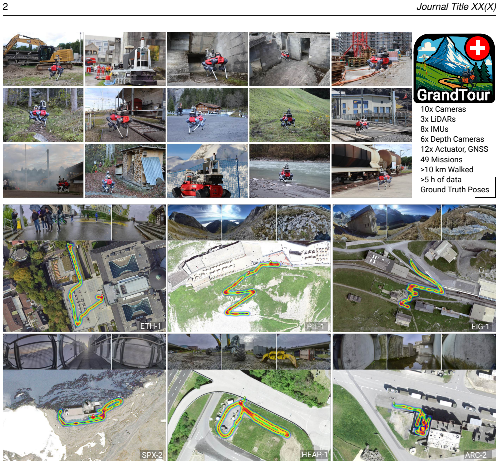
Accurate state estimation and multi-modal perception are prerequisites for autonomous legged robots in complex, large-scale environments. To date, no large-scale public legged-robot dataset captures the real-world conditions needed to develop and benchmark algorithms for legged-robot state estimation, perception, and navigation. To address this, we introduce the GrandTour dataset, a multi-modal legged-robotics dataset collected across challenging outdoor and indoor environments, featuring an ANYbotics ANYmal-D quadruped equipped with the Boxi multi-modal sensor payload. GrandTour spans a broad range of environments and operational scenarios across distinct test sites, ranging from alpine scenery and forests to demolished buildings and urban areas, and covers a wide variation in scale, complexity, illumination, and weather conditions. The dataset provides time-synchronized sensor data from spinning LiDARs, multiple RGB cameras with complementary characteristics, proprioceptive sensors, and stereo depth cameras. Moreover, it includes high-precision ground-truth trajectories from satellite-based RTK-GNSS and a Leica Geosystems total station. This dataset supports research in SLAM, high-precision state estimation, and multi-modal learning, enabling rigorous evaluation and development of new approaches to sensor fusion in legged robotic systems. With its extensive scope, GrandTour represents the largest open-access legged-robotics dataset to date. The dataset is available at https://grand-tour.leggedrobotics.com on HuggingFace (ROS-independent), and in ROS formats, along with tools and demo resources.
Figures


Forward citations
Cited by 13 Pith papers
-
CaLiSym: Learning Symplectic Dynamics of Real-World Systems through Structured Canonical Lifts
Exact symplectic learning extends to open robotic systems via an algebraic structured canonical lift, improving OOD autoregressive prediction on pendulum, quadrotor, and quadruped with parameter-efficient SympNets.
-
ForEnt: A Multi-Modal Dataset for Characterizing Quadruped Robot Entrapments in Forest Environments
ForEnt is a new dataset of time-synchronized RGB-D, LiDAR, proprioceptive and third-person video recordings from 69 labeled forest entrapment events collected across eight sites with a quadruped robot.
-
FARM: Find Anything using Relational Spatial Memory
FARM creates an open-vocabulary relational spatial memory that improves object retrieval recall by 164-224% over prior methods on 44k language queries across 67 scenes while running at 5-10 Hz.
-
G-PROBE: Cross-FOV Place Recognition and Certainty-Coupled Localization for 3D Point Clouds
A learning-free cross-FOV ensemble plus certainty-coupled GICP keeps place recognition and 6-DoF localization usable under extreme FOV asymmetry and wide-to-narrow cross-sensor pairing where prior methods collapse.
-
FARM: Find Anything using Relational Spatial Memory
A real-time relational spatial memory that parses object queries into spatial predicates, scores them against per-object 3D Gaussians, and retrieves object instances with substantially higher top-K recall than prior s...
-
Green for Go, Red for No: Visual Grounding via Semantic Segmentation for VLA Navigation Policies
Real-time SegFormer green/red overlays reduce OmniVLA far-waypoint error 27-44% on Grand Tour language goals mainly by shortening trajectories, with little help for image goals.
-
Chalito: An Extensible Library for Filtering-Based State Estimation in Quadruped Robots
Chalito is the first open-source library dedicated to benchmarking filter-based state estimators for quadruped robots across robots and datasets via URDF-driven, filter-agnostic interfaces.
-
CaLiSym: Learning Symplectic Dynamics of Real-World Systems through Structured Canonical Lifts
Lifting non-conservative, actuated, and contact-constrained robot dynamics into an exactly symplectic phase-space map yields state-of-the-art out-of-distribution autoregressive rollout error at low parameter and FLOP cost.
-
Sensor Configuration Matters: A Systematic Evaluation of Multimodal SLAM on Quadruped Robots
Systematic evaluation on an ANYmal D quadruped shows stereo global-shutter cameras outperform monocular, RGB-D, and rolling-shutter setups, while standard inertial integration can degrade vision-based SLAM under legge...
-
Iterated Invariant EKF for Quadruped Robot Odometry
An IterIEKF algorithm for quadruped odometry, relying on proprioceptive kinematic constraints, outperforms vanilla IEKF and SO(3) Kalman filters in accuracy and consistency on simulations and real datasets.
-
Ultra-Fusion: A Resilient Tightly-Coupled Multi-Sensor Fusion SLAM Framework under Sensor Degradation and Spatiotemporal Perturbation for Intelligent Transportation Systems
Ultra-Fusion presents a unified sliding-window estimator for multi-sensor fusion SLAM supporting WIO/VIO/LIO/LVIO with observability-aware initialization, factor-wise reliability scheduling, and online spatiotemporal ...
-
Multimodal embodiment-aware navigation transformer
ViLiNT improves goal-conditioned navigation success rates by 166% on average over vision-only baselines across simulations and real rover tests by combining multimodal sensing with embodiment-conditioned diffusion tra...
-
A Proprioceptive-Only Benchmark for Quadruped State Estimation: ATE, RPE, and Runtime Trade-offs Between Filters and Smoothers
Benchmark of MUSE, IEKF, and IS on CYN-1 sequence shows similar RPEs, lower ATE for IEKF and IS, and accuracy-latency trade-offs with open-source evaluation code.
Reference graph
Works this paper leans on
-
[1]
IEEE Robotics and Automation Letters 7(2): 4861--4868
Bai C, Xiao T, Chen Y, Wang H, Zhang F and Gao X (2022) Faster-lio: Lightweight tightly coupled lidar-inertial odometry using parallel sparse incremental voxels. IEEE Robotics and Automation Letters 7(2): 4861--4868. doi:10.1109/LRA.2022.3152830
arXiv 2022
-
[2]
Bloesch M, Burri M, Omari S, Hutter M and Siegwart R (2017) Iterated extended kalman filter based visual-inertial odometry using direct photometric feedback. Intl. J. of Robotics Research 36(10): 1053--1072
2017
-
[3]
In: Robotics: Science and Systems (RSS)
Bloesch M, Hutter M, Hoepflinger M, Leutenegger S, Gehring C, Remy CD and Siegwart R (2012) State estimation for legged robots - consistent fusion of leg kinematics and IMU . In: Robotics: Science and Systems (RSS). Sydney, Australia, pp. 3--11. doi:10.15607/RSS.2012.VIII.003
-
[4]
://github.com/ori-drs/allan_variance_ros
Buchanan R (2021) Allan variance ros. ://github.com/ori-drs/allan_variance_ros
2021
-
[5]
In: Conference on robot learning
Buchanan R, Camurri M, Dellaert F and Fallon M (2022) Learning inertial odometry for dynamic legged robot state estimation. In: Conference on robot learning. PMLR, pp. 1575--1584
2022
-
[6]
The International Journal of Robotics Research 42(1-2): 33--42
Burnett K, Yoon DJ, Wu Y, Li AZ, Zhang H, Lu S, Qian J, Tseng WK, Lambert A, Leung KY, Schoellig AP and Barfoot TD (2023) Boreas: A multi-season autonomous driving dataset. The International Journal of Robotics Research 42(1-2): 33--42. doi:10.1177/02783649231160195. ://doi.org/10.1177/02783649231160195
-
[7]
Burri M, Nikolic J, Gohl P, Schneider T, Rehder J, Omari S, Achtelik MW and Siegwart R (2016) The euroc micro aerial vehicle datasets. Intl. J. of Robotics Research 35(10): 1157--1163
2016
-
[8]
IEEE Robotics and Automation Letters 10(10): 10666--10673
Cao Z, Talbot W and Li K (2025) Resple: Recursive spline estimation for lidar-based odometry. IEEE Robotics and Automation Letters 10(10): 10666--10673
2025
-
[9]
In: Proceedings of the IEEE/CVF Conference on Computer Vision and Pattern Recognition (CVPR) Workshops
Chaney K, Cladera F, Wang Z, Bisulco A, Hsieh MA, Korpela C, Kumar V, Taylor CJ and Daniilidis K (2023) M3ed: Multi-robot, multi-sensor, multi-environment event dataset. In: Proceedings of the IEEE/CVF Conference on Computer Vision and Pattern Recognition (CVPR) Workshops. pp. 4015--4022
2023
-
[10]
IEEE Robotics and Automation Letters
Chen J, Frey J, Zhou R, Miki T, Martius G and Hutter M (2024 a ) Identifying terrain physical parameters from vision-towards physical-parameter-aware locomotion and navigation. IEEE Robotics and Automation Letters
2024
-
[11]
IEEE Robotics and Automation Letters 7(2): 2000--2007
Chen K, Lopez BT, Agha-mohammadi Aa and Mehta A (2022) Direct lidar odometry: Fast localization with dense point clouds. IEEE Robotics and Automation Letters 7(2): 2000--2007. doi:10.1109/LRA.2022.3142739
arXiv 2022
-
[13]
IEEE Robotics and Automation Letters 10(12): 12636--12643
Chen Z, Le Gentil C, Lin F, Lu M, Qiao Q, Xu B, Qi Y and Lu P (2025) Breaking the static assumption: A dynamic-aware lio framework via spatio-temporal normal analysis. IEEE Robotics and Automation Letters 10(12): 12636--12643. doi:10.1109/LRA.2025.3623436
arXiv 2025
-
[14]
IEEE Robotics and Automation Letters 9(2): 1883--1890
Chen Z, Xu Y, Yuan S and Xie L (2024 b ) ig-lio: An incremental gicp-based tightly-coupled lidar-inertial odometry. IEEE Robotics and Automation Letters 9(2): 1883--1890. doi:10.1109/LRA.2024.3349915
arXiv 2024
-
[15]
IEEE Robotics and Automation Letters 10(3): 2998--3005
Choi S and Kim TW (2025) Probabilistic kernel optimization for robust state estimation. IEEE Robotics and Automation Letters 10(3): 2998--3005. doi:10.1109/LRA.2025.3536294
arXiv 2025
-
[16]
Choi S, Park D, Hwang SY and Kim TW (2025) Statistical uncertainty learning for robust visual-inertial state estimation. ://arxiv.org/abs/2510.01648
arXiv 2025
-
[17]
IEEE Robotics and Automation Letters 9(11): 9375--9382
Chung D and Kim J (2024) Nv-liom: Lidar-inertial odometry and mapping using normal vectors towards robust slam in multifloor environments. IEEE Robotics and Automation Letters 9(11): 9375--9382. doi:10.1109/LRA.2024.3457373
arXiv 2024
-
[18]
Georgia Institute of Technology, Tech
Dellaert F (2012) Factor graphs and gtsam: A hands-on introduction. Georgia Institute of Technology, Tech. Rep 2(4)
2012
-
[19]
In: IEEE/RSJ Intl
Erni G, Frey J, Miki T, Mattamala M and Hutter M (2023) Mem: Multi-modal elevation mapping for robotics and learning. In: IEEE/RSJ Intl. Conf. on Intelligent Robots and Systems (IROS). IEEE, pp. 11011--11018
2023
-
[20]
Escontrela A, Kerr J, Allshire A, Frey J, Duan R, Sferrazza C and Abbeel P (2025) Gaussgym: An open-source real-to-sim framework for learning locomotion from pixels. ://arxiv.org/abs/2510.15352
arXiv 2025
-
[21]
In: Proc
Fan Y, Zhao T and Wang G (2024) Schurvins: Schur complement-based lightweight visual inertial navigation system. In: Proc. IEEE Int. Conf. Computer Vision and Pattern Recognition . pp. 17964--17973
2024
-
[22]
IEEE Transactions on Intelligent Transportation Systems 22(3): 1341--1360
Feng D, Haase-Schütz C, Rosenbaum L, Hertlein H, Gläser C, Timm F, Wiesbeck W and Dietmayer K (2021) Deep multi-modal object detection and semantic segmentation for autonomous driving: Datasets, methods, and challenges. IEEE Transactions on Intelligent Transportation Systems 22(3): 1341--1360. doi:10.1109/TITS.2020.2972974
arXiv 2021
-
[23]
IEEE Trans
Feng F, Braun J, Titus A, McGill SG, Ott L, Siegwart R and Nieto J (2023) Scale-aware visual-inertial localization over large areas in real-time on a legged robot. IEEE Trans. Robotics 39(4): 2512--2530
2023
-
[24]
IEEE Robotics and Automation Letters 9(11): 9175--9182
Ferrari S, Giammarino LD, Brizi L and Grisetti G (2024) Mad-icp: It is all about matching data – robust and informed lidar odometry. IEEE Robotics and Automation Letters 9(11): 9175--9182. doi:10.1109/LRA.2024.3456509
arXiv 2024
-
[25]
Firoozi R, Tucker J, Tian S, Majumdar A, Sun J, Liu W, Zhu Y, Song S, Kapoor A, Hausman K, Ichter B, Driess D, Wu J, Lu C and Schwager M (2025) Foundation models in robotics: Applications, challenges, and the future. Intl. J. of Robotics Research 44(5): 701--739. doi:10.1177/02783649241281508
-
[26]
In: Robotics: Science and Systems (RSS)
Frey J, Mattamala M, Chebrolu N, Cadena C, Fallon M and Hutter M (2023) Fast Traversability Estimation for Wild Visual Navigation . In: Robotics: Science and Systems (RSS). Daegu, Republic of Korea, pp. 54--70. doi:10.15607/RSS.2023.XIX.054. ://roboticsproceedings.org/rss19/p054.html
-
[27]
In: Robotics: Science and Systems (RSS)
Frey J, Tuna T, Fu LFT, Weibel C, Patterson K, Krummenacher B, M \"u ller M, Nubert J, Fallon M, Cadena C and Hutter M (2025) Boxi : Design decisions in the context of algorithmic performance for robotics. In: Robotics: Science and Systems (RSS). Los Angeles, United States, pp. 1--9
2025
-
[28]
Fu LFT, Chebrolu N and Fallon M (2023) Extrinsic calibration of camera to lidar using a differentiable checkerboard model. In: IEEE/RSJ Intl. Conf. on Intelligent Robots and Systems (IROS). pp. 1825--1831. doi:10.1109/IROS55552.2023.10341781
arXiv 2023
-
[29]
In: IEEE/RSJ Intl
Furgale P, Rehder J and Siegwart R (2013) Unified temporal and spatial calibration for multi-sensor systems. In: IEEE/RSJ Intl. Conf. on Intelligent Robots and Systems (IROS). IEEE, pp. 1280--1286
2013
-
[30]
Geiger A, Lenz P, Stiller C and Urtasun R (2013) Vision meets robotics: The kitti dataset. Intl. J. of Robotics Research 32(11): 1231--1237
2013
-
[31]
Gelfand N, Ikemoto L, Rusinkiewicz S and Levoy M (2003) Geometrically stable sampling for the icp algorithm. In: Intl. Conf. on 3-D Digital Imaging and Modeling (3DIM). pp. 260--267. doi:10.1109/IM.2003.1240258
Pith/arXiv arXiv 2003
-
[32]
Geneva P, Eckenhoff K, Lee W, Yang Y and Huang G (2020) Openvins: A research platform for visual-inertial estimation. In: IEEE Intl. Conf. on Robotics and Automation (ICRA). pp. 4666--4672. doi:10.1109/ICRA40945.2020.9196524
arXiv 2020
-
[33]
https://github.com/MichaelGrupp/evo
Grupp M (2017) evo: Python package for the evaluation of odometry and slam. https://github.com/MichaelGrupp/evo
2017
-
[34]
IEEE Robotics and Automation Letters 9(12): 11234--11241
Hatleskog J and Alexis K (2024) Probabilistic degeneracy detection for point-to-plane error minimization. IEEE Robotics and Automation Letters 9(12): 11234--11241. doi:10.1109/LRA.2024.3484153
arXiv 2024
-
[35]
Advanced Intelligent Systems 5(7): 2200459
He D, Xu W, Chen N, Kong F, Yuan C and Zhang F (2023) Point-lio: robust high-bandwidth light detection and ranging inertial odometry. Advanced Intelligent Systems 5(7): 2200459
2023
-
[36]
IEEE Robotics and Automation Letters 7(3): 7518--7525
Helmberger M, Morin K, Berner B, Kumar N, Cioffi G and Scaramuzza D (2022) The hilti slam challenge dataset. IEEE Robotics and Automation Letters 7(3): 7518--7525
2022
-
[37]
Hu X, Chen X, Jia M, Wu J, Tan P and Waslander SL (2025) Dcreg: Decoupled characterization for efficient degenerate lidar registration. ://arxiv.org/abs/2509.06285
arXiv 2025
-
[38]
Huai Z and Huang G (2024) A consistent parallel estimation framework for visual-inertial slam. IEEE Trans. Robotics 40: 3734--3755. doi:10.1109/TRO.2024.3433868
arXiv 2024
-
[39]
In: 2016 IEEE/RSJ International Conference on Intelligent Robots and Systems (IROS)
Hutter M, Gehring C, Jud D, Lauber A, Bellicoso CD, Tsounis V, Hwangbo J, Bodie K, Fankhauser P, Bloesch M, Diethelm R, Bachmann S, Melzer A and Hoepflinger M (2016) Anymal - a highly mobile and dynamic quadrupedal robot. In: 2016 IEEE/RSJ International Conference on Intelligent Robots and Systems (IROS). pp. 38--44. doi:10.1109/IROS.2016.7758092
arXiv 2016
-
[40]
Inglin Y, Frey J, Chen C and Hutter M (2026) Less is more: Scalable visual navigation from limited data. ://arxiv.org/abs/2601.17815
arXiv 2026
-
[41]
IEEE Sensors Letters 8(3): 1--4
Jeong S, Kim H and Cho Y (2024) Diter: Diverse terrain and multimodal dataset for field robot navigation in outdoor environments. IEEE Sensors Letters 8(3): 1--4
2024
-
[42]
In: 2022 IEEE/RSJ International Conference on Intelligent Robots and Systems (IROS)
Jiao J, Wei H, Hu T, Hu X, Zhu Y, He Z, Wu J, Yu J, Xie X, Huang H, Geng R, Wang L and Liu M (2022) Fusionportable: A multi-sensor campus-scene dataset for evaluation of localization and mapping accuracy on diverse platforms. In: 2022 IEEE/RSJ International Conference on Intelligent Robots and Systems (IROS). pp. 3851--3856. doi:10.1109/IROS47612.2022.9982119
arXiv 2022
-
[43]
Jung JH, Choe Y and Park CG (2022) Photometric visual-inertial navigation with uncertainty-aware ensembles. IEEE Trans. Robotics 38(4): 2039--2052. doi:10.1109/TRO.2021.3139964
arXiv 2022
-
[44]
IEEE Robotics and Automation Letters 8(7): 4211--4218
Jung M, Jung S and Kim A (2023) Asynchronous multiple lidar-inertial odometry using point-wise inter-lidar uncertainty propagation. IEEE Robotics and Automation Letters 8(7): 4211--4218. doi:10.1109/LRA.2023.3281264
arXiv 2023
-
[45]
Kannala J and Brandt S (2006) A generic camera model and calibration method for conventional, wide-angle, and fish-eye lenses. IEEE Trans. Pattern Anal. Machine Intell. 28: 1335--40. doi:10.1109/TPAMI.2006.153
-
[46]
IEEE Robotics and Automation Letters 6(2): 2971--2978
Kim D, Gu Y and Fearing RS (2021 a ) Legged robot state estimation using invariant kalman filtering and learned contact events. IEEE Robotics and Automation Letters 6(2): 2971--2978
2021
-
[47]
IEEE Trans
Kim G, Choi S and Kim A (2021 b ) Scan context++: Structural place recognition robust to rotation and lateral variations in urban environments. IEEE Trans. Robotics 38(3): 1856--1874
2021
-
[48]
In: IEEE Intl
Kim G, Park YS, Cho Y, Jeong J and Kim A (2020) Mulran: Multimodal range dataset for urban place recognition. In: IEEE Intl. Conf. on Robotics and Automation (ICRA). IEEE, pp. 6246--6253
2020
-
[49]
Kim J, Kim H, Jeong S, Shin Y and Cho Y (2024) Diter++: Diverse terrain and multi-modal dataset for multi-robot slam in multi-session environments. ://arxiv.org/abs/2412.05839
Pith/arXiv arXiv 2024
-
[50]
Journal of Robotics and Autonomous Systems 179: 104750
Koide K, Yokozuka M, Oishi S and Banno A (2024) Glim: 3d range-inertial localization and mapping with gpu-accelerated scan matching factors. Journal of Robotics and Autonomous Systems 179: 104750. doi:https://doi.org/10.1016/j.robot.2024.104750. ://www.sciencedirect.com/science/article/pii/S0921889024001349
arXiv 2024
-
[51]
IEEE Robotics and Automation Letters 7(2): 2585--2592
Korthals T, Kragh M, Christiansen P and Karstoft H (2022) Multi-modal semantic slam for complex dynamic environments. IEEE Robotics and Automation Letters 7(2): 2585--2592
2022
-
[52]
arXiv preprint arXiv:2107.04034
Kumar A, Fu Z, Pathak D and Malik J (2021) Rma: Rapid motor adaptation for legged robots. arXiv preprint arXiv:2107.04034
Pith/arXiv arXiv 2021
-
[53]
IEEE Robotics and Automation Letters 8(11): 7074--7081
Lang X, Chen C, Tang K, Ma Y, Lv J, Liu Y and Zuo X (2023) Coco-lic: Continuous-time tightly-coupled lidar-inertial-camera odometry using non-uniform b-spline. IEEE Robotics and Automation Letters 8(11): 7074--7081. doi:10.1109/LRA.2023.3315542
arXiv 2023
-
[54]
IEEE Robotics and Automation Letters 10(1): 152--159
Lee D, Lim H and Han S (2025 a ) GenZ-ICP: Generalizable and Degeneracy-Robust LiDAR Odometry Using an Adaptive Weighting . IEEE Robotics and Automation Letters 10(1): 152--159. doi:10.1109/LRA.2024.3498779
arXiv 2025
-
[55]
IEEE Trans
Lee MA, Zhu Y, Srinivasan K, Shah P, Savarese S, Fei-Fei L, Garg A and Bohg J (2020) Making sense of vision and touch: Self-supervised learning of multimodal representations for contact-rich tasks. IEEE Trans. Robotics 36(3): 582--596
2020
-
[56]
Lee W, Geneva P, Chen C and Huang G (2025 b ) Mins: Efficient and robust multisensor-aided inertial navigation system. J. of Field Robotics 42(7): 3252--3284
2025
-
[57]
arXiv preprint arXiv:2202.09199
Leutenegger S (2022) OKVIS2 : Realtime scalable visual‑inertial slam with loop closure. arXiv preprint arXiv:2202.09199
Pith/arXiv arXiv 2022
-
[58]
Li C, Krause A and Hutter M (2025) Robotic world model: A neural network simulator for robust policy optimization in robotics. ://arxiv.org/abs/2501.10100
arXiv 2025
-
[59]
In: IEEE Intl
Liang J, Song D, Shuvo MNH, Durrani M, Taranath K, Penskiy I, Manocha D and Xiao X (2025) Gnd: Global navigation dataset with multi-modal perception and multi-category traversability in outdoor campus environments. In: IEEE Intl. Conf. on Robotics and Automation (ICRA). IEEE, pp. 11345--11352
2025
-
[60]
Lin J, Yuan C, Cai Y, Li H, Ren Y, Zou Y, Hong X and Zhang F (2023) Immesh: An immediate lidar localization and meshing framework. IEEE Trans. Robotics 39(6): 4312--4331. doi:10.1109/TRO.2023.3321227
arXiv 2023
-
[61]
IEEE Robotics and Automation Letters 8(3): 1523--1530
Liu X, Liu Z, Kong F and Zhang F (2023) Large-scale lidar consistent mapping using hierarchical lidar bundle adjustment. IEEE Robotics and Automation Letters 8(3): 1523--1530
2023
-
[62]
Liu Z, Li H, Yuan C, Liu X, Lin J, Li R, Zheng C, Zhou B, Liu W and Zhang F (2024) Voxel-slam: A complete, accurate, and versatile lidar-inertial slam system. ://arxiv.org/abs/2410.08935
Pith/arXiv arXiv 2024
-
[63]
Lv J, Lang X, Xu J, Wang M, Liu Y and Zuo X (2023) Continuous-time fixed-lag smoothing for lidar-inertial-camera slam. IEEE/ASME Trans. Mechatron. 28(4): 2259--2270. doi:10.1109/TMECH.2023.3241398
arXiv 2023
-
[64]
Maddern W, Pascoe G, Linegar C and Newman P (2017) 1\,000 km of autonomy: The oxford robotcar dataset. Intl. J. of Robotics Research 36(1): 3--15. doi:10.1177/0278364916679498
-
[65]
arXiv preprint arXiv:2509.06593
Malladi M, Guadagnino T, Lobefaro L and Stachniss C (2025) A robust approach for lidar-inertial odometry without sensor-specific modeling. arXiv preprint arXiv:2509.06593. ://arxiv.org/pdf/2509.06593
Pith/arXiv arXiv 2025
-
[66]
IEEE Access 11: 144918--144927
Meng K, Sun H, Qi J and Wang H (2023) Section-lio: A high accuracy lidar-inertial odometry using undistorted sectional point. IEEE Access 11: 144918--144927. doi:10.1109/ACCESS.2023.3344037
arXiv 2023
-
[67]
Science robotics 7(62): eabk2822
Miki T, Lee J, Hwangbo J, Wellhausen L, Koltun V and Hutter M (2022 a ) Learning robust perceptive locomotion for quadrupedal robots in the wild. Science robotics 7(62): eabk2822
2022
-
[68]
In: IEEE Intl
Miki T, Lee J, Wellhausen L and Hutter M (2024) Learning to walk in confined spaces using 3d representation. In: IEEE Intl. Conf. on Robotics and Automation (ICRA). IEEE, pp. 8649--8656
2024
-
[69]
In: IEEE/RSJ Intl
Miki T, Wellhausen L, Grandia R, Jenelten F, Homberger T and Hutter M (2022 b ) Elevation mapping for locomotion and navigation using gpu. In: IEEE/RSJ Intl. Conf. on Intelligent Robots and Systems (IROS). IEEE, pp. 2273--2280
2022
-
[70]
IEEE Robotics and Automation Letters 9(6): 5330--5337
Nguyen TM, Xu X, Jin T, Yang Y, Li J, Yuan S and Xie L (2024 a ) Eigen is all you need: Efficient lidar-inertial continuous-time odometry with internal association. IEEE Robotics and Automation Letters 9(6): 5330--5337. doi:10.1109/LRA.2024.3391049
arXiv 2024
-
[71]
In: Proc
Nguyen TM, Yuan S, Nguyen TH, Yin P, Cao H, Xie L, Wozniak M, Jensfelt P, Thiel M, Ziegenbein J and Blunder N (2024 b ) Mcd: Diverse large-scale multi-campus dataset for robot perception. In: Proc. IEEE Int. Conf. Computer Vision and Pattern Recognition . pp. 22304--22313
2024
-
[72]
Nubert J, Tuna T, Frey J, Cadena C, Kuchenbecker KJ, Khattak S and Hutter M (2025) Holistic fusion: Task- and setup-agnostic robot localization and state estimation with factor graphs. ://arxiv.org/abs/2504.06479
Pith/arXiv arXiv 2025
-
[73]
Nwankwo L, Ellensohn B, Dave V, Hofer P, Forstner J, Villneuve M, Galler R and Rueckert E (2025) Envodat: A large-scale multisensory dataset for robotic spatial awareness and semantic reasoning in heterogeneous environments. ://arxiv.org/abs/2410.22200
arXiv 2025
-
[74]
Olson E (2011) Apriltag: A robust and flexible visual fiducial system. In: IEEE Intl. Conf. on Robotics and Automation (ICRA). pp. 3400--3407. doi:10.1109/ICRA.2011.5979561
arXiv 2011
-
[75]
Patel M, Frey J, Mittal M, Yang F, Hansson A, Bar A, Cadena C and Hutter M (2026) Defm: Learning foundation representations from depth for robotics. ://arxiv.org/abs/2601.18923
arXiv 2026
-
[76]
Peng Y, Chen C, Wu K and Huang G (2025) vins : Robust and ultrafast square-root filter-based 3d motion tracking. IEEE Trans. Robotics 41: 6570--6589. doi:10.1109/TRO.2025.3626607
arXiv 2025
-
[77]
IEEE Robotics and Automation Letters 9(6): 5230--5237
Petracek P, Alexis K and Saska M (2024) Rms: Redundancy-minimizing point cloud sampling for real-time pose estimation. IEEE Robotics and Automation Letters 9(6): 5230--5237. doi:10.1109/LRA.2024.3389820
arXiv 2024
-
[78]
P \"u ntener C, Schwabe J, Garmier D, Frey J and Hutter M (2025) Kleinkram: Open robotic data management. ://arxiv.org/abs/2511.20492
arXiv 2025
-
[79]
Pérez-Ruiz C and Solà J (2026) Limoncello: Iterated error-state kalman filter on the sgal(3) manifold for fast lidar-inertial odometry. ://arxiv.org/abs/2512.19567
arXiv 2026
-
[80]
Qin T, Li P and Shen S (2018) Vins-mono: A robust and versatile monocular visual-inertial state estimator. IEEE Trans. Robotics 34(4): 1004--1020. doi:10.1109/TRO.2018.2853729
arXiv 2018
-
[81]
Qin T and Shen S (2018) Online temporal calibration for monocular visual-inertial systems. In: IEEE/RSJ Intl. Conf. on Intelligent Robots and Systems (IROS). pp. 3662--3669. doi:10.1109/IROS.2018.8593603
arXiv 2018
discussion (0)
Sign in with ORCID, Apple, or X to comment. Anyone can read and Pith papers without signing in.