SE(2) Navigation Mesh
Pith reviewed 2026-07-03 19:55 UTC · model grok-4.3
The pith
SE(2) Navigation Mesh encodes yaw-dependent traversability via footprint masks to support non-circular ground robots in tight spaces.
A machine-rendered reading of the paper's core claim, the machinery that carries it, and where it could break.
Core claim
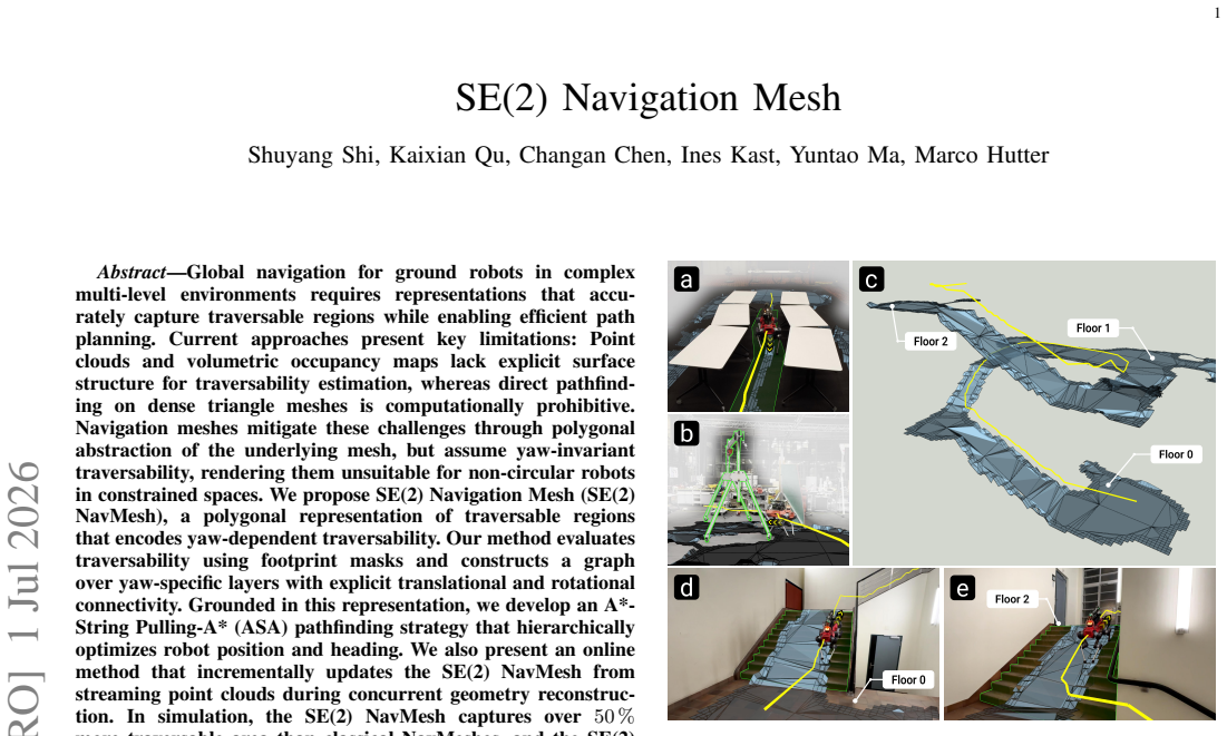
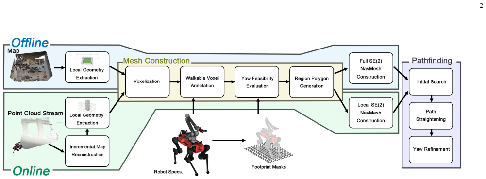
We propose SE(2) Navigation Mesh (SE(2) NavMesh), a polygonal representation of traversable regions that encodes yaw-dependent traversability. Our method evaluates traversability using footprint masks and constructs a graph over yaw-specific layers with explicit translational and rotational connectivity. Grounded in this representation, we develop an A*-String Pulling-A* (ASA) pathfinding strategy that hierarchically optimizes robot position and heading. We also present an online method that incrementally updates the SE(2) NavMesh from streaming point clouds during concurrent geometry reconstruction.
What carries the argument
The SE(2) Navigation Mesh: a yaw-layered polygonal abstraction whose edges and faces are labeled by footprint-mask traversability and connected by both translational and rotational transitions.
If this is right
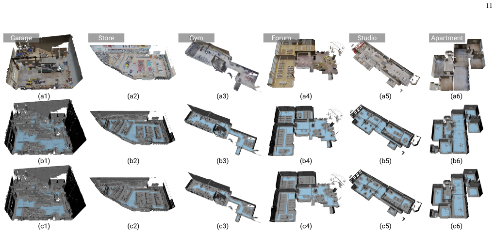
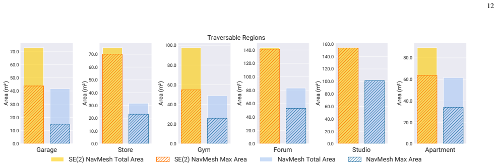
- In simulation the representation captures over 50 percent more traversable area than yaw-invariant meshes.
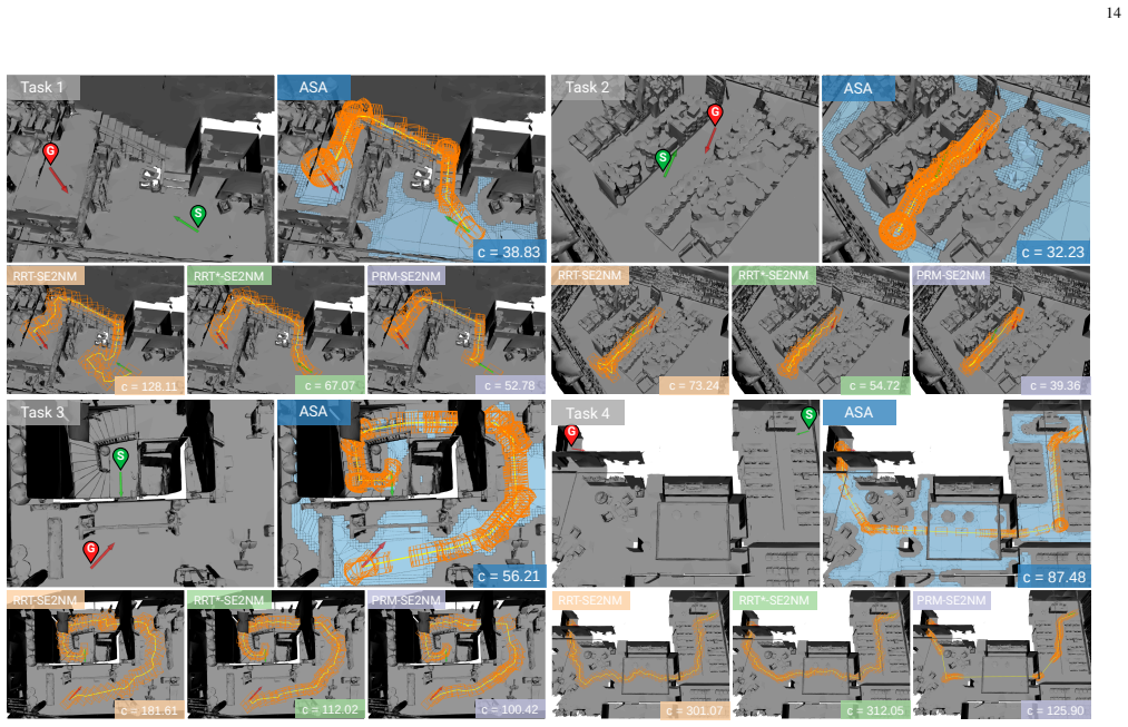
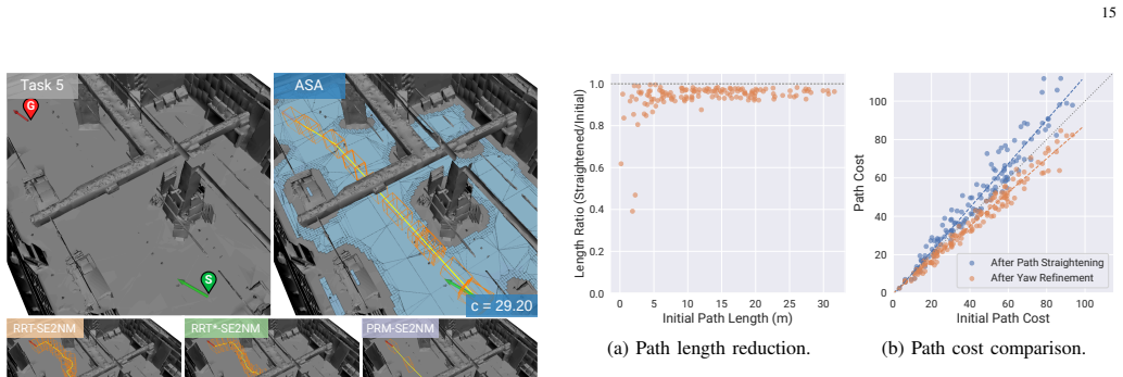
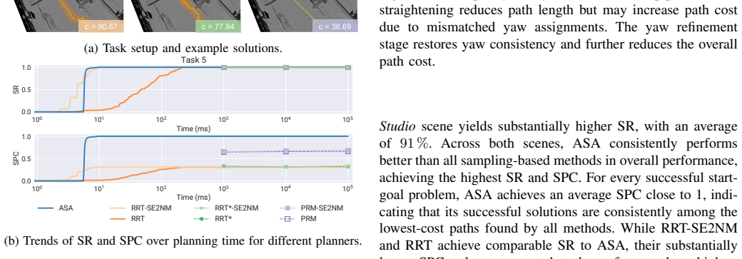
- The combined SE(2) NavMesh plus ASA planner consistently beats sampling-based baselines inside constrained environments.
- An incremental online builder maintains the mesh in real time from streaming point clouds while the robot moves.
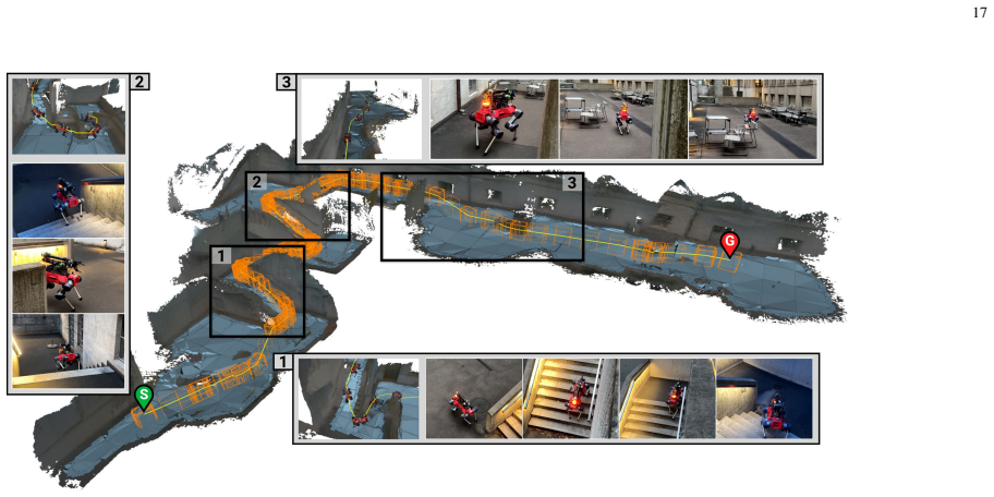
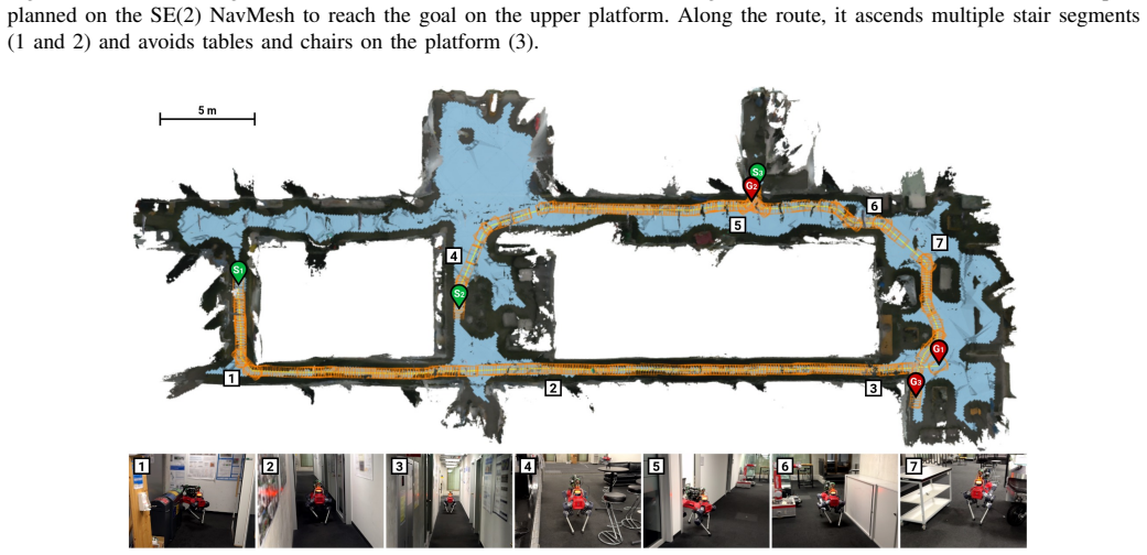
- Real-world trials on a physical platform confirm successful navigation across multiple indoor and outdoor settings.
Where Pith is reading between the lines
- The same layered-mask idea could be applied to 3-D aerial vehicles whose clearance also varies with pitch and roll.
- Replacing static footprint masks with learned or sensor-driven masks would test whether the representation remains useful under heavy occlusion or deformable terrain.
- The explicit rotational edges already present in the graph offer a natural substrate for adding dynamic obstacle avoidance that accounts for heading.
Load-bearing premise
Footprint masks evaluated on the underlying geometry provide a sufficient and accurate model of yaw-dependent traversability without systematic under- or over-estimation in real geometry or sensor noise.
What would settle it
A physical robot test in which the SE(2) NavMesh predicts a feasible heading-specific path but the robot collides or gets stuck while the same path is infeasible under a classical NavMesh would falsify the core claim.
Figures





read the original abstract
Global navigation for ground robots in complex multi-level environments requires representations that accurately capture traversable regions while enabling efficient path planning. Current approaches present key limitations: Point clouds and volumetric occupancy maps lack explicit surface structure for traversability estimation, whereas direct pathfinding on dense triangle meshes is computationally prohibitive. Navigation meshes mitigate these challenges through polygonal abstraction of the underlying mesh, but assume yaw-invariant traversability, rendering them unsuitable for non-circular robots in constrained spaces. We propose SE(2) Navigation Mesh (SE(2) NavMesh), a polygonal representation of traversable regions that encodes yaw-dependent traversability. Our method evaluates traversability using footprint masks and constructs a graph over yaw-specific layers with explicit translational and rotational connectivity. Grounded in this representation, we develop an A*-String Pulling-A* (ASA) pathfinding strategy that hierarchically optimizes robot position and heading. We also present an online method that incrementally updates the SE(2) NavMesh from streaming point clouds during concurrent geometry reconstruction. In simulation, the SE(2) NavMesh captures over 50% more traversable area than classical NavMeshes, and the SE(2) NavMesh + ASA pipeline consistently outperforms sampling-based baselines in constrained environments. Extensive real-world experiments on a physical robot validate real-time online generation and successful navigation across multiple environments.
Editorial analysis
A structured set of objections, weighed in public.
Referee Report
Summary. The paper proposes the SE(2) Navigation Mesh, a polygonal abstraction of traversable space that encodes yaw-dependent traversability via footprint-mask evaluation on underlying geometry. It constructs a layered graph with explicit translational and rotational edges, introduces an A*-String Pulling-A* (ASA) hierarchical planner, and provides an incremental online update procedure from streaming point clouds. Simulation results claim >50% more traversable area than yaw-invariant NavMeshes and consistent outperformance versus sampling-based planners in constrained settings; real-robot experiments are said to confirm real-time generation and successful navigation.
Significance. If the footprint-based yaw modeling and performance claims are substantiated with quantitative controls, the representation could usefully extend classical navigation meshes to non-circular robots without incurring the cost of full SE(2) sampling or dense volumetric search. The online reconstruction component would be a practical addition for field deployment.
major comments (2)
- [Abstract / Method description] Abstract and method description: the central 50% area-gain and outperformance claims rest on footprint-mask traversability evaluation being an accurate proxy for yaw-specific collisions. No cross-validation against executed robot trajectories, sensor-noise injection, or partial-occlusion cases is reported, leaving open the possibility of systematic false-positive or false-negative area estimates.
- [Results / Experiments] Results section (implied by abstract claims): quantitative details on baselines, exact metrics (e.g., success rate, path length, clearance), environment selection criteria, number of trials, and statistical tests are absent, so the statements that the SE(2) NavMesh + ASA pipeline “consistently outperforms” sampling-based methods cannot be assessed for robustness.
minor comments (2)
- [Method] Clarify the precise discretization of yaw layers and the definition of inter-layer rotational edges; the connectivity construction is described at a high level but lacks an explicit algorithm or complexity statement.
- [Figures] Figure captions and axis labels should explicitly state the robot footprint dimensions and mask resolution used in the reported experiments.
Simulated Author's Rebuttal
We thank the referee for the constructive feedback on validation and experimental reporting. We address each major comment below and indicate the corresponding revisions.
read point-by-point responses
-
Referee: [Abstract / Method description] Abstract and method description: the central 50% area-gain and outperformance claims rest on footprint-mask traversability evaluation being an accurate proxy for yaw-specific collisions. No cross-validation against executed robot trajectories, sensor-noise injection, or partial-occlusion cases is reported, leaving open the possibility of systematic false-positive or false-negative area estimates.
Authors: The SE(2) NavMesh defines traversability directly via footprint-mask evaluation on the input geometry, which is the basis for both the simulated area comparison and the incremental point-cloud reconstruction. Real-robot experiments demonstrate collision-free navigation using paths from this representation, providing indirect support. We agree that explicit cross-validation against executed trajectories, injected sensor noise, and partial occlusions is not reported and would strengthen the claims. We will add a dedicated limitations subsection discussing these assumptions and the potential for discrepancies in noisy or occluded settings. revision: partial
-
Referee: [Results / Experiments] Results section (implied by abstract claims): quantitative details on baselines, exact metrics (e.g., success rate, path length, clearance), environment selection criteria, number of trials, and statistical tests are absent, so the statements that the SE(2) NavMesh + ASA pipeline “consistently outperforms” sampling-based methods cannot be assessed for robustness.
Authors: We will revise the results section to provide the requested quantitative details, including the specific baselines, metrics (success rate, path length, clearance), environment selection criteria, number of trials, and any statistical tests performed. This will enable a clearer assessment of the robustness of the reported outperformance. revision: yes
Circularity Check
No significant circularity; central claims rest on external empirical comparisons
full rationale
The SE(2) NavMesh is constructed directly from footprint-mask traversability checks on the input geometry and standard graph layering; the reported >50% area gain and navigation improvements are measured against the independently defined classical (yaw-invariant) NavMesh baseline in simulation and real-robot experiments. No equations, fitted parameters, or self-citations are shown to reduce these quantities to the inputs by construction. The derivation chain remains self-contained against external benchmarks.
Axiom & Free-Parameter Ledger
axioms (1)
- domain assumption Footprint masks evaluated against surface geometry yield reliable yaw-dependent traversability labels
Reference graph
Works this paper leans on
-
[1]
Review of robotic infrastructure inspection systems,
D. Lattanzi and G. Miller, “Review of robotic infrastructure inspection systems,”Journal of Infrastructure Systems, vol. 23, no. 3, p. 04017004, 2017
work page 2017
-
[2]
Robots in inspection and monitoring of buildings and infrastructure: A systematic review,
S. Halder and K. Afsari, “Robots in inspection and monitoring of buildings and infrastructure: A systematic review,”Applied Sciences, vol. 13, no. 4, p. 2304, 2023
work page 2023
-
[3]
H. Miura, A. Watanabe, M. Okugawa, T. Miura, and T. Koganeya, “Plant inspection by using a ground vehicle and an aerial robot: lessons learned from plant disaster prevention challenge in world robot summit 2018,” Advanced Robotics, vol. 34, no. 2, pp. 104–118, 2020
work page 2018
-
[4]
P. Kim, J. Park, Y . K. Cho, and J. Kang, “Uav-assisted autonomous mobile robot navigation for as-is 3d data collection and registration in cluttered environments,”Automation in Construction, vol. 106, p. 102918, 2019
work page 2019
-
[5]
Evaluation of a smart mobile robotic system for industrial plant inspection and supervision,
G. K. Fischer, M. Bergau, D. A. G ´omez-Rosal, A. Wachaja, J. Graeter, M. Odenweller, U. Piechottka, F. H ¨oflinger, N. Gosala, N. Wetzel et al., “Evaluation of a smart mobile robotic system for industrial plant inspection and supervision,”IEEE Sensors Journal, vol. 24, no. 12, pp. 19 684–19 697, 2024
work page 2024
-
[6]
Learning robust perceptive locomotion for quadrupedal robots in the wild,
T. Miki, J. Lee, J. Hwangbo, L. Wellhausen, V . Koltun, and M. Hutter, “Learning robust perceptive locomotion for quadrupedal robots in the wild,”Science Robotics, vol. 7, no. 62, p. eabk2822, 2022
work page 2022
-
[7]
Legged locomotion in challenging terrains using egocentric vision,
A. Agarwal, A. Kumar, J. Malik, and D. Pathak, “Legged locomotion in challenging terrains using egocentric vision,” inConference on robot learning. PMLR, 2023, pp. 403–415
work page 2023
-
[8]
Towards autonomous inspection of concrete deterioration in sewers with legged robots,
H. Kolvenbach, D. Wisth, R. Buchanan, G. Valsecchi, R. Grandia, M. Fallon, and M. Hutter, “Towards autonomous inspection of concrete deterioration in sewers with legged robots,”Journal of field robotics, vol. 37, no. 8, pp. 1314–1327, 2020
work page 2020
-
[9]
Funda- mentals and prospects of four-legged robot application in construction progress monitoring,
K. Afsari, S. Halder, M. Ensafi, S. DeVito, and J. Serdakowski, “Funda- mentals and prospects of four-legged robot application in construction progress monitoring,”EPiC series in built environment, vol. 2, pp. 274– 283, 2021
work page 2021
-
[10]
3d exploration and navigation with optimal-rrt planners for ground robots in indoor incidents,
N. P ´erez-Higueras, A. Jard ´on, ´A. Rodr ´ıguez, and C. Balaguer, “3d exploration and navigation with optimal-rrt planners for ground robots in indoor incidents,”Sensors, vol. 20, no. 1, p. 220, 2019
work page 2019
-
[11]
Far planner: Fast, attemptable route planner using dynamic visibility update,
F. Yang, C. Cao, H. Zhu, J. Oh, and J. Zhang, “Far planner: Fast, attemptable route planner using dynamic visibility update,” in2022 ieee/rsj international conference on intelligent robots and systems (iros). IEEE, 2022, pp. 9–16
work page 2022
-
[12]
Marsim: A light-weight point-realistic simulator for lidar- based uavs,
F. Kong, X. Liu, B. Tang, J. Lin, Y . Ren, Y . Cai, F. Zhu, N. Chen, and F. Zhang, “Marsim: A light-weight point-realistic simulator for lidar- based uavs,”IEEE Robotics and Automation Letters, vol. 8, no. 5, pp. 2954–2961, 2023
work page 2023
-
[13]
Robotic online path planning on point cloud,
M. Liu, “Robotic online path planning on point cloud,”IEEE transac- tions on cybernetics, vol. 46, no. 5, pp. 1217–1228, 2015
work page 2015
-
[14]
P. Kr ¨usi, P. Furgale, M. Bosse, and R. Siegwart, “Driving on point clouds: Motion planning, trajectory optimization, and terrain assessment in generic nonplanar environments,”Journal of Field Robotics, vol. 34, no. 5, pp. 940–984, 2017
work page 2017
-
[15]
Efficient global nav- igational planning in 3-d structures based on point cloud tomography,
B. Yang, J. Cheng, B. Xue, J. Jiao, and M. Liu, “Efficient global nav- igational planning in 3-d structures based on point cloud tomography,” IEEE/ASME Transactions on Mechatronics, vol. 30, no. 1, pp. 321–332, 2025
work page 2025
-
[16]
V oxblox: Incremental 3d euclidean signed distance fields for on-board mav planning,
H. Oleynikova, Z. Taylor, M. Fehr, R. Siegwart, and J. Nieto, “V oxblox: Incremental 3d euclidean signed distance fields for on-board mav planning,” in2017 IEEE/RSJ International Conference on Intelligent Robots and Systems (IROS). IEEE, 2017, pp. 1366–1373
work page 2017
-
[17]
Octomap: An efficient probabilistic 3d mapping framework based on octrees,
A. Hornung, K. M. Wurm, M. Bennewitz, C. Stachniss, and W. Burgard, “Octomap: An efficient probabilistic 3d mapping framework based on octrees,”Autonomous robots, vol. 34, no. 3, pp. 189–206, 2013
work page 2013
-
[18]
Ego-planner: An esdf- free gradient-based local planner for quadrotors,
X. Zhou, Z. Wang, H. Ye, C. Xu, and F. Gao, “Ego-planner: An esdf- free gradient-based local planner for quadrotors,”IEEE Robotics and Automation Letters, vol. 6, no. 2, pp. 478–485, 2020. 19
work page 2020
-
[19]
Y . Ren, Y . Cai, F. Zhu, S. Liang, and F. Zhang, “Rog-map: An efficient robocentric occupancy grid map for large-scene and high- resolution lidar-based motion planning,” in2024 IEEE/RSJ International Conference on Intelligent Robots and Systems (IROS). IEEE, 2024, pp. 8119–8125
work page 2024
-
[20]
Towards efficient trajectory generation for ground robots beyond 2d environment,
J. Wang, L. Xu, H. Fu, Z. Meng, C. Xu, Y . Cao, X. Lyu, and F. Gao, “Towards efficient trajectory generation for ground robots beyond 2d environment,” in2023 IEEE International Conference on Robotics and Automation (ICRA). IEEE, 2023, pp. 7858–7864
work page 2023
-
[21]
J. Frey, D. Hoeller, S. Khattak, and M. Hutter, “Locomotion policy guided traversability learning using volumetric representations of com- plex environments,” in2022 IEEE/RSJ International Conference on Intelligent Robots and Systems (IROS). IEEE, 2022, pp. 5722–5729
work page 2022
-
[22]
Using occupancy grids for mobile robot perception and navigation,
A. Elfes, “Using occupancy grids for mobile robot perception and navigation,”Computer, vol. 22, no. 6, pp. 46–57, 2002
work page 2002
-
[23]
Robot-centric elevation mapping with uncertainty estimates,
P. Fankhauser, M. Bloesch, C. Gehring, M. Hutter, and R. Siegwart, “Robot-centric elevation mapping with uncertainty estimates,” inMobile Service Robotics. World Scientific, 2014, pp. 433–440
work page 2014
-
[24]
Probabilistic terrain mapping for mobile robots with uncertain localization,
P. Fankhauser, M. Bloesch, and M. Hutter, “Probabilistic terrain mapping for mobile robots with uncertain localization,”IEEE Robotics and Automation Letters, vol. 3, no. 4, pp. 3019–3026, 2018
work page 2018
-
[25]
Elevation mapping for locomotion and navigation using gpu,
T. Miki, L. Wellhausen, R. Grandia, F. Jenelten, T. Homberger, and M. Hutter, “Elevation mapping for locomotion and navigation using gpu,” in2022 IEEE/RSJ International Conference on Intelligent Robots and Systems (IROS). IEEE, 2022, pp. 2273–2280
work page 2022
-
[26]
Habitat-Matterport 3D Dataset (HM3D): 1000 Large-scale 3D Environments for Embodied AI
S. K. Ramakrishnan, A. Gokaslan, E. Wijmans, O. Maksymets, A. Clegg, J. Turner, E. Undersander, W. Galuba, A. Westbury, A. X. Changet al., “Habitat-matterport 3d dataset (hm3d): 1000 large-scale 3d environments for embodied ai,”arXiv preprint arXiv:2109.08238, 2021
work page internal anchor Pith review Pith/arXiv arXiv 2021
-
[27]
M. Khanna*, Y . Mao*, H. Jiang, S. Haresh, B. Shacklett, D. Batra, A. Clegg, E. Undersander, A. X. Chang, and M. Savva, “Habitat Synthetic Scenes Dataset (HSSD-200): An Analysis of 3D Scene Scale and Realism Tradeoffs for ObjectGoal Navigation,”arXiv preprint, 2023
work page 2023
-
[28]
Ovpc mesh: 3d free-space representation for lo- cal ground vehicle navigation,
F. Ruetz, E. Hern ´andez, M. Pfeiffer, H. Oleynikova, M. Cox, T. Lowe, and P. Borges, “Ovpc mesh: 3d free-space representation for lo- cal ground vehicle navigation,” in2019 International Conference on Robotics and Automation (ICRA). IEEE, 2019, pp. 8648–8654
work page 2019
-
[29]
Continuous shortest path vector field navigation on 3d triangular meshes for mo- bile robots,
S. P ¨utz, T. Wiemann, M. K. Piening, and J. Hertzberg, “Continuous shortest path vector field navigation on 3d triangular meshes for mo- bile robots,” in2021 IEEE International Conference on Robotics and Automation (ICRA), 2021, pp. 2256–2263
work page 2021
-
[30]
A comparative study of navigation meshes,
W. Van Toll, R. Triesscheijn, M. Kallmann, R. Oliva, N. Pelechano, J. Pettr´e, and R. Geraerts, “A comparative study of navigation meshes,” inProceedings of the 9th International Conference on Motion in Games, 2016, pp. 91–100
work page 2016
-
[31]
Unity Technologies, “Navigation overview,” https://docs.unity3d.com/ Packages/com.unity.ai.navigation@2.0/manual/NavigationOverview. html, 2026
work page 2026
-
[32]
Epic Games, “Navigation system,” https://dev. epicgames.com/documentation/en-us/unreal-engine/ navigation-system-in-unreal-engine, 2024
work page 2024
-
[33]
K. Yadav, J. Krantz, R. Ramrakhya, S. K. Ramakrishnan, J. Yang, A. Wang, J. Turner, A. Gokaslan, V .-P. Berges, R. Mootaghi, O. Maksymets, A. X. Chang, M. Savva, A. Clegg, D. S. Chaplot, and D. Batra, “Habitat challenge 2023,” https://aihabitat.org/challenge/2023/, 2023
work page 2023
-
[34]
M. Brandao, O. B. Aladag, and I. Havoutis, “GaitMesh: Controller-aware navigation meshes for long-range legged locomotion planning in multi- layered environments,”IEEE Robotics and Automation Letters, vol. 5, no. 2, pp. 3596–3603, 2020
work page 2020
-
[35]
M. Mononen, “Recast Navigation,” https://github.com/recastnavigation/ recastnavigation, 2014
work page 2014
-
[36]
Processing and interactive editing of huge point clouds from 3d scanners,
M. Wand, A. Berner, M. Bokeloh, P. Jenke, A. Fleck, M. Hoffmann, B. Maier, D. Staneker, A. Schilling, and H.-P. Seidel, “Processing and interactive editing of huge point clouds from 3d scanners,”Computers & Graphics, vol. 32, no. 2, pp. 204–220, 2008
work page 2008
-
[37]
X-icp: Localizability-aware lidar registration for robust localization in extreme environments,
T. Tuna, J. Nubert, Y . Nava, S. Khattak, and M. Hutter, “X-icp: Localizability-aware lidar registration for robust localization in extreme environments,”IEEE Transactions on Robotics, vol. 40, pp. 452–471, 2023
work page 2023
-
[38]
Open3d slam: Point cloud based mapping and localization for education,
E. Jelavic, J. Nubert, and M. Hutter, “Open3d slam: Point cloud based mapping and localization for education,” inRobotic Perception and Mapping: Emerging Techniques, ICRA 2022 Workshop. ETH Zurich, Robotic Systems Lab, 2022, p. 24
work page 2022
-
[39]
Tensor voting: Theory and applications,
G. Medioni, C.-K. Tang, and M.-S. Lee, “Tensor voting: Theory and applications,” inProceedings of RFIA, vol. 2000. Hermes, Lavoisier Paris, France, 2000
work page 2000
-
[40]
A note on two problems in connexion with graphs,
E. Dijkstra, “A note on two problems in connexion with graphs,” Numerische Mathematik, vol. 1, no. 1, pp. 269–271, 1959
work page 1959
-
[41]
Rapidly-exploring random trees: Progress and prospects,
S. M. LaValle, “Rapidly-exploring random trees: Progress and prospects,”Algorithmic and Computational Robotics: New Directions 2000 WAFR, p. 293, 2001
work page 2000
-
[42]
Sampling-based algorithms for optimal motion planning,
S. Karaman and E. Frazzoli, “Sampling-based algorithms for optimal motion planning,”The international journal of robotics research, vol. 30, no. 7, pp. 846–894, 2011
work page 2011
-
[43]
Surface reconstruction from unorganized points,
H. Hoppe, T. DeRose, T. Duchamp, J. McDonald, and W. Stuetzle, “Surface reconstruction from unorganized points,” inProceedings of the 19th annual conference on computer graphics and interactive techniques, 1992, pp. 71–78
work page 1992
-
[44]
Real-time 3d reconstruction at scale using voxel hashing,
M. Nießner, M. Zollh ¨ofer, S. Izadi, and M. Stamminger, “Real-time 3d reconstruction at scale using voxel hashing,”ACM Transactions on Graphics (ToG), vol. 32, no. 6, pp. 1–11, 2013
work page 2013
-
[45]
Memory-efficient boundary map for large-scale occupancy grid mapping,
B. Tang, Y . Ren, Y . Cai, F. Kong, W. Liu, F. Zhu, L. Yin, L. Shi, and F. Zhang, “Memory-efficient boundary map for large-scale occupancy grid mapping,”The International Journal of Robotics Research, p. 02783649261425266, 2026
work page 2026
-
[46]
Ufomap: An efficient probabilistic 3d mapping framework that embraces the unknown,
D. Duberg and P. Jensfelt, “Ufomap: An efficient probabilistic 3d mapping framework that embraces the unknown,”IEEE Robotics and Automation Letters, vol. 5, no. 4, pp. 6411–6418, 2020
work page 2020
-
[47]
Smug planner: A safe multi- goal planner for mobile robots in challenging environments,
C. Chen, J. Frey, P. Arm, and M. Hutter, “Smug planner: A safe multi- goal planner for mobile robots in challenging environments,”IEEE Robotics and Automation Letters, vol. 8, no. 11, pp. 7170–7177, 2023
work page 2023
-
[48]
Y . Li, K. Chen, Y . Wang, W. Zhang, J. Wang, H. Chen, and Y . Liu, “Real-time multi-level terrain-aware path planning for ground mobile robots in large-scale rough terrains,”IEEE Transactions on Robotics, 2025
work page 2025
-
[49]
J. Ahtiainen, T. Stoyanov, and J. Saarinen, “Normal distributions trans- form traversability maps: lidar-only approach for traversability mapping in outdoor environments,”Journal of Field Robotics, vol. 34, no. 3, pp. 600–621, 2017
work page 2017
-
[50]
Layered costmaps for context-sensitive navigation,
D. V . Lu, D. Hershberger, and W. D. Smart, “Layered costmaps for context-sensitive navigation,” in2014 IEEE/RSJ International Confer- ence on Intelligent Robots and Systems. IEEE, 2014, pp. 709–715
work page 2014
-
[51]
Rough terrain navigation for legged robots using reachability planning and template learning,
L. Wellhausen and M. Hutter, “Rough terrain navigation for legged robots using reachability planning and template learning,” in2021 IEEE/RSJ International Conference on Intelligent Robots and Systems (IROS). IEEE, 2021, pp. 6914–6921
work page 2021
-
[52]
Lazy collision checking in asymptotically-optimal motion planning,
K. Hauser, “Lazy collision checking in asymptotically-optimal motion planning,” in2015 IEEE international conference on robotics and automation (ICRA). IEEE, 2015, pp. 2951–2957
work page 2015
-
[53]
Real-time optimal navigation planning using learned motion costs,
B. Yang, L. Wellhausen, T. Miki, M. Liu, and M. Hutter, “Real-time optimal navigation planning using learned motion costs,” in2021 IEEE International Conference on Robotics and Automation (ICRA). IEEE, 2021, pp. 9283–9289
work page 2021
-
[54]
Surface recon- struction from arbitrarily large point clouds,
T. Wiemann, I. Mitschke, A. Mock, and J. Hertzberg, “Surface recon- struction from arbitrarily large point clouds,” in2018 Second IEEE International Conference on Robotic Computing (IRC). IEEE, 2018, pp. 278–281
work page 2018
-
[55]
Rrt-connect: An efficient approach to single-query path planning,
J. J. Kuffner and S. M. LaValle, “Rrt-connect: An efficient approach to single-query path planning,” inProceedings 2000 ICRA. Millennium conference. IEEE international conference on robotics and automation. Symposia proceedings (Cat. No. 00CH37065), vol. 2. IEEE, 2000, pp. 995–1001
work page 2000
-
[56]
A formal basis for the heuristic determination of minimum cost paths,
P. E. Hart, N. J. Nilsson, and B. Raphael, “A formal basis for the heuristic determination of minimum cost paths,”IEEE transactions on Systems Science and Cybernetics, vol. 4, no. 2, pp. 100–107, 1968
work page 1968
-
[57]
A*-based pathfinding in modern computer games,
X. Cui and H. Shi, “A*-based pathfinding in modern computer games,” International Journal of Computer Science and Network Security, vol. 11, no. 1, pp. 125–130, 2011
work page 2011
-
[58]
Use of watersheds in contour detection,
S. Beucher, “Use of watersheds in contour detection,” inProc. Int. Workshop on Image Processing, Sept. 1979, 1979, pp. 17–21
work page 1979
-
[59]
Triangulation by ear clipping,
D. Eberly, “Triangulation by ear clipping,”Geometric Tools, pp. 2002– 2005, 2008
work page 2002
-
[60]
Simple Stupid Funnel Algorithm,
M. Mononen, “Simple Stupid Funnel Algorithm,” https://digestingduck. blogspot.com/2010/03/simple-stupid-funnel-algorithm.html, 2010
work page 2010
-
[61]
Marching cubes: A high resolution 3d surface construction algorithm,
W. E. Lorensen and H. E. Cline, “Marching cubes: A high resolution 3d surface construction algorithm,”ACM SIGGRAPH Computer Graphics, vol. 21, no. 4, pp. 163–169, 1987
work page 1987
-
[62]
Anymal-a 20 highly mobile and dynamic quadrupedal robot,
M. Hutter, C. Gehring, D. Jud, A. Lauber, C. D. Bellicoso, V . Tsounis, J. Hwangbo, K. Bodie, P. Fankhauser, M. Bloeschet al., “Anymal-a 20 highly mobile and dynamic quadrupedal robot,” in2016 IEEE/RSJ in- ternational conference on intelligent robots and systems (IROS). IEEE, 2016, pp. 38–44
work page 2016
-
[63]
Anymal technical specifications,
ANYbotics, “Anymal technical specifications,” https://www.anybotics. com/anymal-technical-specifications.pdf, 2022
work page 2022
-
[64]
Prob- abilistic roadmaps for path planning in high-dimensional configuration spaces,
L. E. Kavraki, P. Svestka, J.-C. Latombe, and M. H. Overmars, “Prob- abilistic roadmaps for path planning in high-dimensional configuration spaces,”IEEE transactions on Robotics and Automation, vol. 12, no. 4, pp. 566–580, 2002
work page 2002
-
[65]
The open motion planning library,
I. A. Sucan, M. Moll, and L. E. Kavraki, “The open motion planning library,”IEEE Robotics & Automation Magazine, vol. 19, no. 4, pp. 72–82, 2012
work page 2012
-
[66]
On Evaluation of Embodied Navigation Agents
P. Anderson, A. Chang, D. S. Chaplot, A. Dosovitskiy, S. Gupta, V . Koltun, J. Kosecka, J. Malik, R. Mottaghi, M. Savvaet al., “On evalu- ation of embodied navigation agents,”arXiv preprint arXiv:1807.06757, 2018
work page internal anchor Pith review Pith/arXiv arXiv 2018
-
[67]
Success weighted by completion time: A dynamics-aware evaluation criteria for embodied navigation,
N. Yokoyama, S. Ha, and D. Batra, “Success weighted by completion time: A dynamics-aware evaluation criteria for embodied navigation,” in2021 IEEE/RSJ International Conference on Intelligent Robots and Systems (IROS). IEEE, 2021, pp. 1562–1569
work page 2021
discussion (0)
Sign in with ORCID, Apple, or X to comment. Anyone can read and Pith papers without signing in.